| |
eCARTO News December 2016 eCARTO News capture the latest cartographic news and developments from around the world. If you have any general cartography items of interest then please email them to David Fraser, editor of eCARTO News. Our changing world
- Tiny Belgium to get tinier as Netherlands grows after land swap – theage.com.au
- Interactive: Mapping the Flow of International Trade – visualcapitalist.com
- Mapping migrations by using mobile phone data – phys.org
- Mapping the Changes in Europe’s Drug Use – citylab.com
- Mapping Three Decades of Global Water Change – nytimes.com
- Mapping long-term global surface water occurrence – sciencedaily.com
- Ivory Coast adopts unconventional digital address system – cnet.com
- UFO sightings, Amelia Earheart’s final flight and those who died fleeing conflict: Cartographers document history in series of stunning designs – dailymail.co.uk
Modern Cartographic Applications
- Isochrone Maps of Europe – emptypipes.org
- The great American word mapper – qz.com
- “The Arrogance of Space”: Mapping The Unfair Distribution of Public Space at Urban Intersections – archdaily.com
- What a Map of the Fake-News Ecosystem Says About the Problem – fortune.com
Opinion
- Global Commercial Mapping and Surveying Unmanned Aerial Systems Services Market 2016 – Mining & Construction Industries will Drive Steady Growth – Research and Markets – businesswire.com
- Can Data Extracted from Twitter Help Map Flood Hazards? – eos.org
- Smarter mapping makes for more informed decisions – itsinternational.com
- A future version of Google Maps may feature location sharing, more new goodies – digitaltrends.com
- Map shows what every country in the world is ‘best’ at – and Honduras excels at murder, Norway eats the most pizza and Nigeria is best at SCRABBLE – thesun.co.uk
- How Do You Map the Character of a City? A New Tool Offers Solutions – govtech.com
Industry News
- Here and Microsoft extend mapping deal, expanding into connected car data – techcrunch.com
- Apple is poaching Berlin-based mapping engineers from Here – businessinsider.com.au
- Microsoft Partners with TomTom Mapping Company – i4u.com
- Apple Said to Fly Drones to Improve Maps Data and Catch Google – bloomberg.com
- Apple secretly acquired a Finnish company to help it map indoor spaces – businessinsider.com.au
Mapping From Around The World
- What is MapAnt? – mapant.fi
- Créer simplement des cartes thématiques en 3 étapes – sciencespo.fr
- Chinese search giant Baidu extends its mapping service beyond the confines of China – thetechportal.com
- Facebook’s detailed open-source maps show the gaps in global internet connectivity – qz.com
- Discovering India, going places: Google Maps the gaps – deccanherald.com
Imagery
- Sentinels map Earth’s slow surface warping – bbc.com
- Scientists map pollen levels to develop early warning system for asthma sufferers – abc.net.au
- A treasure trove of shipwrecks has been revealed by a new mapping technology – businessinsider.com.au
- Resource-mapping satellite blasts off from India – spaceflightnow.com
- MBARI’s seafloor maps provide new information about 2015 eruption at Axial Seamount – phys.org
- First ever lightning-mapping satellite set for take off – newscientist.com
- GerMAP Launches New Aerial Mapping UAV – gim-international.com
Cartographic ResourcesICA Facebook PostsCartography and the Environment
- New York City Mapped All of its Trees and Calculated the Economic Benefits of Every Single One – archdaily.com
- Mapping the Inundation of New York City – citylab.com
- How to Map a River With Gunpowder – nationalgeographic.com.au
- Team develops algorithm to improve online mapping of disaster areas – phys.org
- Mapping the Early Range of the African Elephant – psmag.com
- Global surface water and historical changes map – gearthblog.com
Mapping Infrastructure
- 30 Years of Oil and Gas Pipeline Accidents, Mapped – citylab.com
- Drones Mapping Indian Cities – Where They’re Allowed – voanews.com
- Mapping underground infrastructure: one dig at a time – cso.com.au
- Six maps that show the anatomy of America’s vast infrastructure – washingtonpost.com
The Politics of Mapping
- Google Disappointed by South Korean Refusal on Mapping Data – voanews.com
- CIA declassified maps of Afghanistan, Russia, released – news.com.au
Adult Learning Courses
Drawing the Line: The Creative Potential of Maps – bl.uk- Mapping the Future – bl.uk
| | | | |
Pluto and Charon mapped – for children 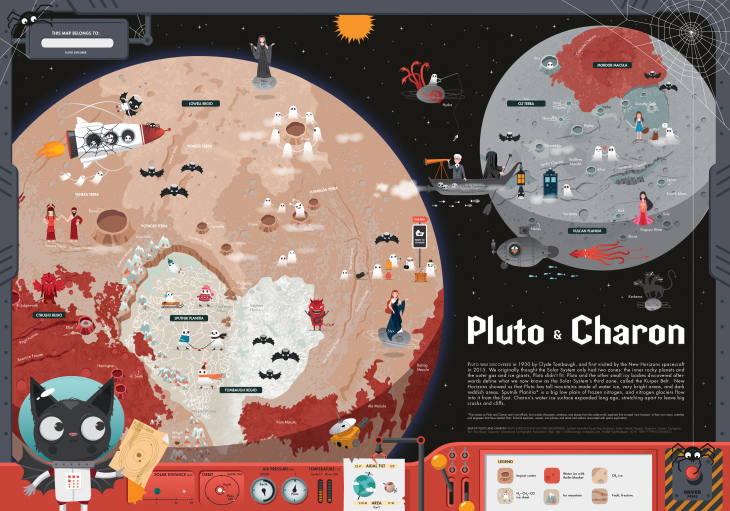
The new map showing the New Horizons encounter hemispheres of Pluto and Charon is the result of a cooperation between the worlds of planetary science, cartography and arts. It is the 7th map in the series of multilingual maps of planets and moons designed for children. The map shows the geology of the surface together with characters taken from the informal nomenclature. The map of the double planet, the larger named after Pluto, the god of the underworld; and the smaller after Charon, the ferryman between the worlds of the living and the dead, has the theme of the Halloween. A specialty of this map compared to other, “scientific” maps is that while keeping cartographic accuracy, it links arts and science, and visualizes features in a way that is easier to interpret for the non-scientists. The map premiered at the AGU Fall Meeting in San Francisco last week. The map is joint effort of graphic artist Adrienn Gyöngyösi and scientists working at NASA and SETI Institute (Henrik Hargitai, editor; and Ross Beyer who contributed with the text describing Pluto). This nonprofit project is supported by the International Cartographic Association. The map is free to download at childrensmaps.wordpress.com Contact: henrik.i.hargitai//at//nasa.gov [ Press release ] | | | | |
President’s Blog: Season’s Greetings Dear cartographers, 2016 has been an exciting year, the International Map Year. All over the world we have seen special events being organized related to maps. I would like to thank everyone of you who has contributed and made the International Map Year a success. For ICA, the poster exhibition at the United Nations headquarters has been one of the highlights, especially since the nineteen posters are the result of a concerted effort of all our commissions and working groups. I’m convinced the spirit of the International Map year will not get lost when 2017 starts. Actually, that seems impossible because the next big event is in full preparation: our 28th International Cartographic Conference in Washington, D.C., USA, next July. The local organizers are working hard to make it a success. You have contributed over seven hundred submissions which are currently under review, promising an interesting and high quality program. Via this blog post I would like to bring you the Executive Committee’s season’s greetings and wish you a Mappy 2017. – Menno-Jan Kraak
President of the International Cartographic Association
 The ICA Executive Committee wishes Happy Holidays and a prosperous New Year! | | | | |
Invitation to the 12th ICA Conference on Digital Approaches to Cartographic Heritage 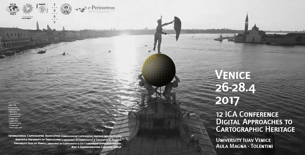
You are invited to participate and present a paper in the 12th ICA Conference on Digital Approaches to Cartographic Heritage to be held in Venice, Italy, 26–28 April 2016. The ICA Commission on Cartographic Heritage into the Digital, continuing the tradition of its annual Cartoheritage Conferences since 2006, is organising the 12th Conference on Digital Approaches to Cartographic Heritage in Venice, Italy, 26-28 April 2017, in partnership with the IUAV – Laboratory of Cartography & GIS and Laboratory of Photogrammetry, the AUTH CartoGeoLab – Laboratory of Cartography & Geographical Analysis, and the MAGIC – Map & Geoinformation Curators Group. The conference is organised in thematic sessions dedicated to issues relevant to the subjects usually treated in the conferences of the ICA Cartoheritage Commission, according to its Terms of Reference (2015–2019) and the topics treated by its Working Units:
- Digitisation – Georeference.
- Content analysis in terms of geometry and thematics of cartodiversity.
- Landscape change studies based on map-archival sources.
- Visualisation of Cartoheritage, including thematic portals.
- Interconnection of cartographic archival sources, especially map and textual data.
- Historical terrestrial and aerial photography, including photo-related post-cards and relevant material – cartographic parametrisation.
- Cartoheritage web providing issues.
- Interaction of cartoheritage with map and geoinformation curatorship of cartodiversity.
- Development of catoheritage as a cultural issue, within the context of GLAM, addressed to education and to the general public.
- Geographic affinities with Cartoheritage.
- Cartoheritage and Digital Humanities.
- Other relevant issues of Cartoheritage ecosystem.
The conference is kindly hosted by the University IUAV of Venice; all working sessions will take place in IUAV’s Aula Magna, Tolentini, Santa Croce (see venue). For more information about the conference please visit cartography.web.auth.gr/ICA-Heritage/Venice2017/. | | | | |
Invitation to the ICA Pre-Conference Workshop Charting the Cosmos of Cartography: History – Names – Atlases 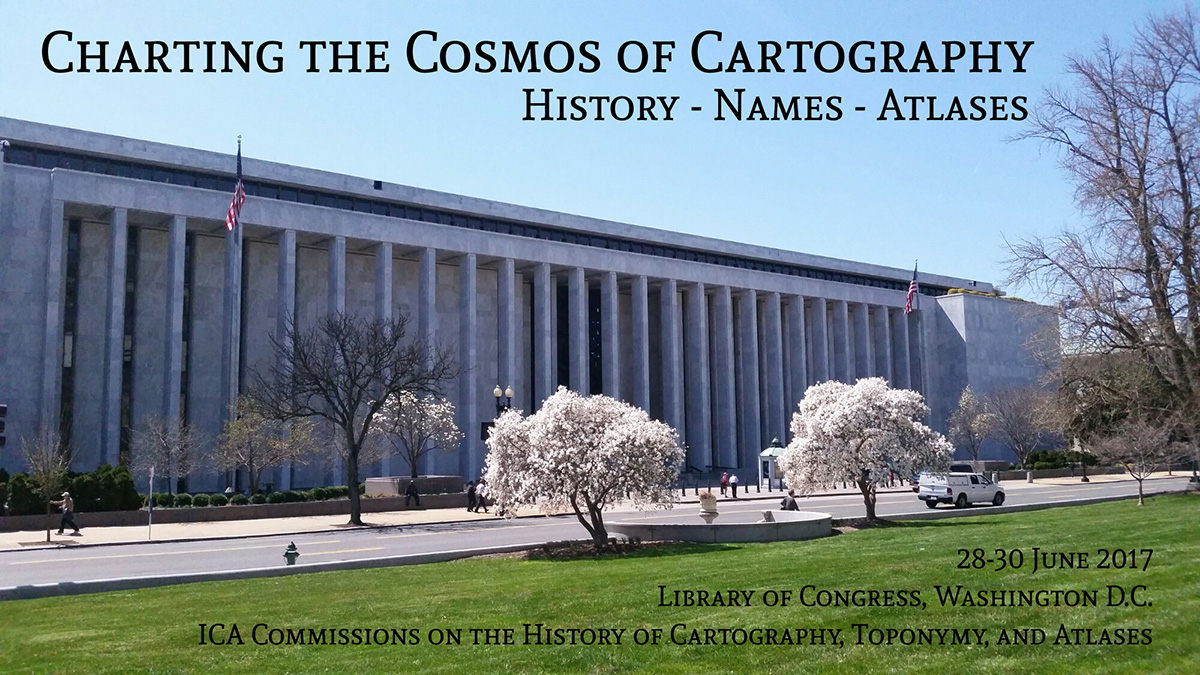
In conjunction with the 28th International Cartographic Conference, held in Washington DC on 2–7 July 2017 (http://icc2017.org/), the Library of Congress’ Geography & Map Division and the three ICA Commissions on the History of Cartography, Toponymy, and Atlases would like to invite you to attend their joint pre-conference Workshop Charting the Cosmos of Cartography: History – Names – Atlases. The workshop will be held at the Library of Congress (Madison Building) in Washington DC (USA), from Wednesday, 28 June to Friday, 30 June 2017. Call for Papers
- Deadline for submissions: 15 February 2017
- Notification of acceptance: 15 March 2017
Participants are invited to submit abstracts on any topic of merit addressing at least one of the subjects of the partnering ICA Commissions. The abstracts should be between 200 and 500 words long, written in English and provided as a Word file using this template. A brief biographical note should also be provided at the end of the abstract. Each author, either as sole author or co-author, may only submit one paper proposal; each paper has to be an original contribution that has not been published or presented before. All submissions must be sent electronically via the online submission system. When submitting, authors will also be asked to indicate their interest to write a full paper after the conference which – if enough authors are interested – will be published in a dedicated conference volume. Please find more information and updates on the workshop website: history.icaci.org/washington-dc-2017 | | | | |
Invitation to the International Symposium Mapping Asia – Cartographic Encounters between East and West 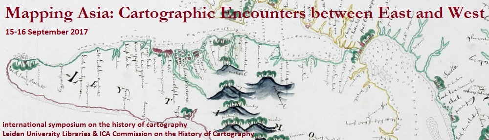
Leiden University Libraries and the ICA Commission on the History of Cartography kindly invite you to attend the International Symposium Mapping Asia – Cartographic Encounters between East and West on 15–16 September 2017 in Leiden, Netherlands. The central theme of the conference is the mutual influence of Western and Asian cartographic traditions. The focus will be on where Western and Asian cartographic history meet. Geographically, the topics will be limited to South Asia, East Asia and Southeast Asia with special attention to India, China, Japan, Korea and Indonesia.
- Topics and questions which will be discussed are:
- What defines Asia? The arbitrary borders between Europe and Asia on the map
- Asian cartographic traditions
- Asian toponomy and cartography
- Cartography and intercultural contact
- Missionary and colonial cartographies of Asia
- Asian cartography in the collections of Leiden University Libraries
- Philipp Franz von Siebold and the cartography of Japan
- and all papers of merit
During the symposium Leiden University Library will expose several exhibitions. The Asian collections of the special collections are internationally famous. The Bodel Nijenhuis Collection has large numbers of historical VOC maps. The Indonesia collection has many maps of the 19th and 20th century and includes the collections from the Royal Tropical Institute (KIT) and the Royal Netherlands Institute of Southeast Asian and Caribbean Studies (KITLV). The Siebold collection contains a lot of Japanese maps and the collection of the Sinology Institute holds several Chinese maps. 
The symposium is held within the framework of the Leiden Asia Year. Throughout 2017, Leiden will be the leading center for Asia in terms of research, teaching, collections and expertise. The Leiden Asia Year 2017 was prompted by the building of the Asian Library on the roof of the University Library. The Asian Library will be opened on 14 September 2017. Participants are kindly invited to attend the opening of the Asian Library, the day before the symposium starts. Fore more information, please consult the workshop website: blogs.library.leiden.edu/mappingasia | | | | |
How to win an ICA Map Award We received several questions on how to submit a map for consideration of an ICA Map Award, so we would like to give you some details on the process: At each International Cartographic Conference, an International Cartographic Exhibition is organized, where map products originating from ICA national members and ICA affiliate members are exhibited. The maps sent to the exhibition are authorized and selected by the ICA national or affiliate member. An international jury then selects the best exhibits in various categories. The next International Cartographic Conference will take place in Washington, D.C., USA, 2–7 July 2017. The deadline for national representatives to nominate maps for the cartographic exhibition is 16 May, 2017. All exhibited material must have been edited or modified after August 2015 (the date of the last ICC in Rio de Janeiro, Brazil). More details can be found in the Guide for Participation in the International Cartographic Exhibition. Each country may have different policies regarding the coordination of the exhibit materials. However, if you know a cartographically excellent product, which might be worth a map award, please make your national representative aware of it! We are looking forward to a broad range of high-quality entries.
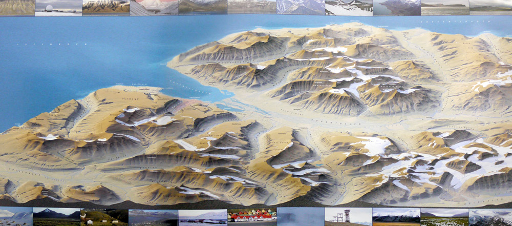 ICA Map Awards 2015: 1st place paper maps – 3D Map Longyearbyen and environs (Norway). An overview of all winners of the ICA Map Awards 2015 can be found here. | | | | |
Summary of the workshop on Advancing GIScience with Open Source Technologies 
AutoCarto is a Cartography and Geographic Information Society (CaGIS) research symposium held every two years. CaGIS is the US adhering body to the ICA. AutoCarto 2016 was held in Albuquerque, New Mexico, USA, 14 – 16 September 2016. The ICA Commission on Open Source Geospatial Technologies held a very well-attended, successful one-day workshop on Advancing GIScience with Open Source Technologies the day before the start of Auto Carto. The agenda (details below) consisted of seven invited speakers and an open discussion session. The Chair of the commission, Silvana Camboim, opened the presentations and led the discussion. The Vice-Chair, Michael P. Finn, organized the workshop and served as the moderator. All the presentations are available on GitHub at this URL: https://github.com/mfinnCEGIS/workshopAdvancingGIScienceOST/, which includes the original agenda announcing the workshop and a subdirectory of photographs. There were 22 attendees from six nations, including the President of ICA, Menno-Jan Kraak, who sat in during the afternoon and contributed to the lively open discussion. In addition, at the start of the discussion session, Helena Mitasova, North Carolina State University, USA, did a short, overview presentation of “Geo forAll.” AgendaInvited Speakers (30 minutes each for presentation and questions)
- Experiences on How Openness Can Help to Reduce Inequality – Silvana Camboim, Federal University of Paraná – UFPR, BRAZIL, Commission Chair
- GRASS GIS as open source innovation platform: from dynamic visualizations to collaborative tangible modeling – Helena Mitasova, North Carolina State University, USA, co-authors: Anna Petrasova, Vaclav Petras, and Brendan Harmon
- Open-Source Software in the Cutting Edge Geocomputaion Research at ORNL – Alex Sorokine, Oak Ridge National Laboratory (ORNL), USA
- Keeping Map Data Current Through the Use of Volunteered Geographic Information – James McAndrew, Colorado State University, contractor to the US National Park Service, USA
- Teaching Open Source Web Mapping – Carl Sack, University of Wisconsin–Madison, USA, co-author: Robert Roth
- Doing Datacubes in Open-Source: the rasdaman Scalable Array Engine – Peter Baumann, Jacobs University Bremen, GERMANY
- Development of an Open Source 3D Browser to Visualize Modeling Results – Syed Monjur Murshed, European Institute for Energy Research (EIFER), GERMANY, co-authors: Jochen Wendel, Akila Sriramulu, and Alexandru Nichersu
Open Discussion: Future Directions: Thinking About the Road Ahead – chaired by Silvana Camboim – Michael P. Finn
Vice-Chair, ICA Commission on Open Source Geospatial Technologies | | | | |
| |
|