Welcome to the International Cartographic Association
Welcome to the website of the International Cartographic AssociationGet to know the new ICA Executive Committee for the term 2023-2027
Welcome to the website of the International Cartographic Association
Get to know the new ICA Executive Committee for the term 2023-2027

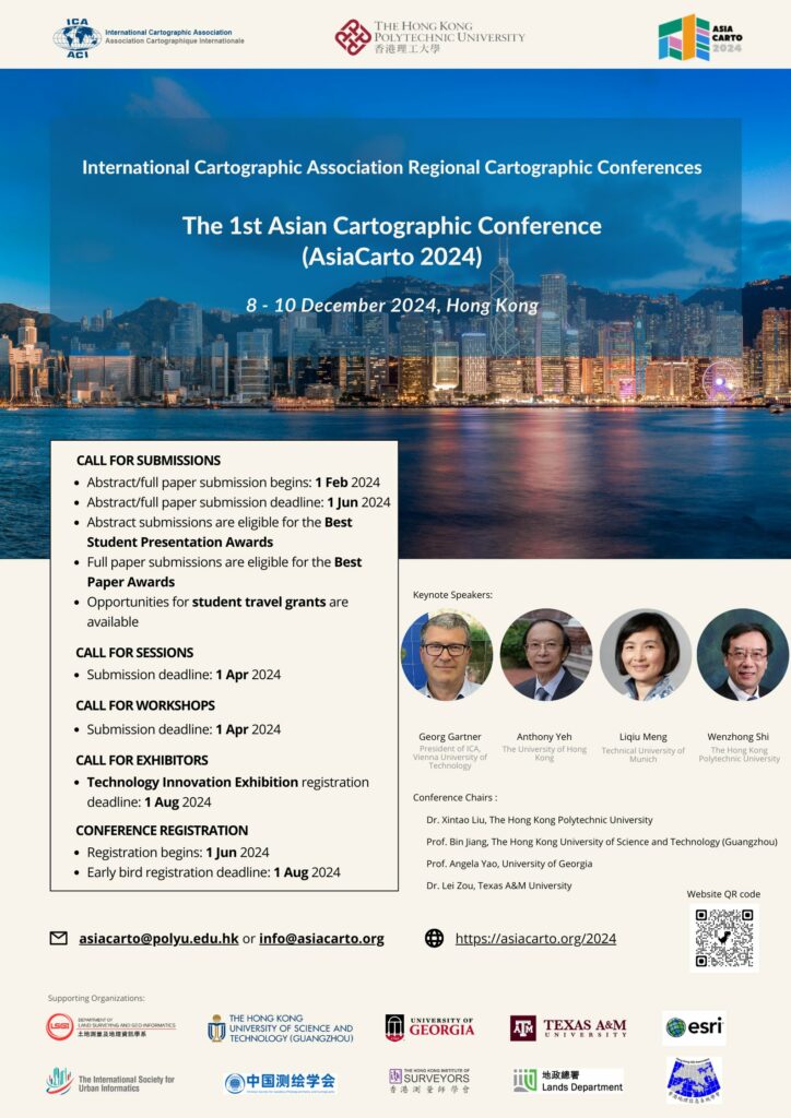
Invitation to AsiaCarto 2024 – The First Asian Cartographic Conference of ICA

The International Cartographic Association (ICA) and The Hong Kong Polytechnic University (PolyU) are pleased to initiate the first Regional Cartographic Conferences (RCC) in Asia, namely Asian Cartographic Conference (AsiaCarto 2024). AsiaCarto 2024 will be held from 8th to 10th December 2024 at the Hong Kong Polytechnic University, Hong Kong, China.

AsiaCarto 2024 aims to bring together Cartographers, GIS scientists, and professionals from related fields to provide a platform for discussion, exchange, and stimulation of research and collaborative projects on Cartography and GIScience. In the long run, AsiaCarto envisions becoming a biannual series of conferences hosted in various Asian countries, consistently supporting the promotion of Cartography and GIScience within Asia and worldwide.

We invite submissions, session proposals, workshop proposals, and exhibitor applications! Don’t miss out on the chance to win prestigious awards such as Best Paper, Best Presentation, and Student Travel Grants. For detailed information registration, please visit AsiaCarto 2024’s official website. ICA has also opened up its Scholarship programme for this new Regional Cartographic Conference. The deadline for Scholarship applications by young scientists is 7 August 2024: https://icaci.org/scholarship/

We are happy to welcome you to AsiaCarto 2024 in Hong Kong!

Category: Member News
Tag:

Invitation to CartoVis 2024 – ICA Workshop on AI, Geovisualization, and Analytical Reasoning

The University of Warsaw Department of Geoinformatics, Cartography, and Remote Sensing in collaboration with the International Cartographic Association Commissions on Cognitive Issues in Geographic Information VisualizationGeovisualization, and User Experience (UX), as well as ICA Next Generation Cartographers Working Group are pleased to invite you to the 2024 ICA Workshop on AI, Geovisualization, and Analytical Reasoning, on Saturday, 7 September 2024 at the University of Warsaw, Poland.

Early-stage work is explicitly encouraged, especially by junior scholars or those new to cartography.

We invite you to contribute to our Call for Papers. Short papers (2 pages) can be submitted until 15 May 2024 and abstracts (300 words) until 1 June 2024. Submissions are expected to report on ongoing and emergent work that aims to tackle one of the many dimensions of cartography: specifically, we welcome those that relate to supporting geovisualization and analytical reasoning, including approaches that leverage AI methods applied at various stages: data processing, analysis, visualization generation and interpretation, as well as support in user perception interpretation. Broadly speaking, we are seeking work that focuses on understanding users, their cognitive processes, and/or their interactions with visual representations and computational methods via maps or geographic visualization. We welcome research that tackles these and related problem areas through computational, representational, artificial intelligence (AI), ethical, or contextual methodological lenses. This workshop will provide a forum in which new approaches and ideas can be discussed and where new research collaborations can be formed.

There will be no conference fee!

For details please visit our workshop website: http://carto-vis-workshop.uw.edu.pl/ 

We are looking forward to your contributions and to welcoming you to Warsaw!

CartoVis24 Organizers

Tag: ,

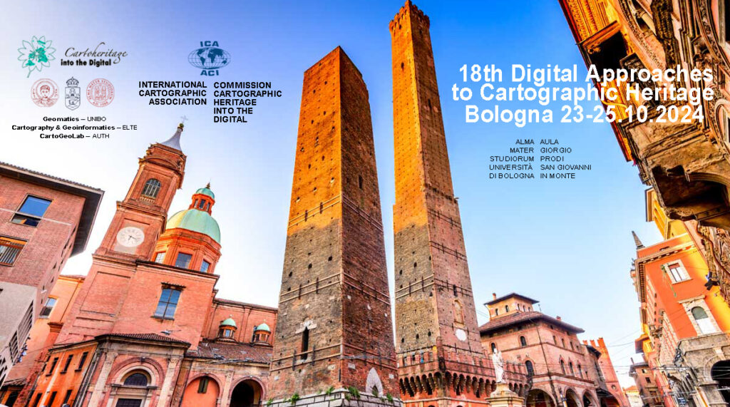
Invitation to the 18th ICA Conference on Digital Approaches to Cartographic Heritage

The ICA Commission on Cartographic Heritage into the Digital, continuing the tradition of its annual Cartoheritage Conferences since 2006, is pleased to invite you at the 18th ICA Conference on Digital Approaches to Cartographic Heritage in Bologna, 23-25 October 2024 – in partnership with the the University of Bologna, Department of Civil, Chemical, Environmental and Materials Engineering (DICAM), supported by the MAGIC – Map & Geoinformation Curators Group.

Call for Papers

The Programme will be organised in thematic sessions dedicated to issues relevant to the subjects usually treated in the Conferences of the ICA Cartoheritage Commission, according to its Terms of Reference (2023-2027).

Possible topics include but are not limited to:

  • Digitisation – Georeference.
  • Content analysis in terms of geometry and thematics of cartodiversity.
  • Landscape change studies based on map-archival sources.
  • Visualisation of Cartoheritage, including thematic portals.
  • Interconnection of cartographic archival sources, especially map and textual data.
  • Historical terrestrial and aerial photography, including photo-related post-cards and relevant material – cartographic parametrisation.
  • Cartoheritage web providing issues.
  • Interaction of cartoheritage with map and geoinformation curatorship of cartodiversity.
  • Development of cartoheritage as a cultural issue, within the context of GLAM, addressed to education and to the general public.
  • Geographic affinities with Cartoheritage.
  • Cartoheritage and Digital Humanities.
  • Other relevant issues of the Cartoheritage ecosystem.

The presented papers are published in the Conference Proceedings (ISSN-2459-3893) available in digital form during the Conference.

For your participation in the conference, please fill and submit online your participation form.

For abstract submission, please fill and submit online the paper title & abstract form (Deadline: 30 April 2024)

For more information about the conference please visit cartography.web.auth.gr/ICA-Heritage/Bologna2024.

Tag: ,

eCARTO News February 2024

eCARTO News captures the latest cartographic news and developments from around the world. If you have any general cartography items of interest then please email them to David Fraser, editor of eCARTO News.

Navigation and Cartography

“As It Happens” Cartography

  • UK weather – msn.com
  • Map of large grass fire north of North Platte – knopnews2.com
  • Map Shows California Cities to Get Hit Hardest With Rain – newsweek.com
  • Map shows where AT&T outages hit cellphone users across the U.S. – finance.yahoo.com
  • Natchitoches unveils new online crime mapping system – ktbs.com
  • New interactive map shows spread of measles across London – mylondon.news

Risk Mapping

  • Map plots riskiest chemical release hot spots – eenews.net
  • Tent City Nation: Mapping stories of homeless encampments across Canada – ottawacitizen.com
  • Map shows where “explosive hurricanes” could hit the United States after weather warning issued – irishstar.com
  • Where are U.S. earthquakes most likely? A new map shows the hazard risks – sciencenews.org

Applications of Mapping

  • Advanced Aerial Mapping Unveils England’s Hedgerows – miragenews.com
  • Ohio eclipse map – fox8.com
  • Researchers use the latest technology to more accurately map the Oregon Trail over the Blue Mountains – eastoregonian.com
  • North Dakota Tourism releases enhanced website interactive map and website features – valleynewslive.com
  • Interactive map of Frederick Douglass’ influence across America will be available to public – news.iu.edu
  • Bridger-Teton National Forest seeks input on Story Map – localnews8.com
  • Genoa Township Updates Radon Map – whmi.com

Environment

  • Wetlands map identifies areas that could be affected by sea level rise – baytobaynews.com
  • Map reveals US states with 100% fatal ‘zombie deer disease’ – metro.co.uk
  • Google joins mission to map methane from space – bbc.com

Social media and maps

  • Instagram is working on a ‘Friend Map’ feature that would let you track friends’ locations – yahoo.com

Opinion

  • Mapping Earth’s atmospheric rivers could help improve predictions for intense rain – news.yahoo.com
  • Maps are guided by power, not truth – iai.tv

Just Atlases & Maps

  • Photoatlas Series – Photoatlas Series
  • Mappa Mundi: The greatest medieval map in the world – bbc.com
  • Great Bend Museum unveils restored historic 1796 map of Jackson County – wvnews.com
  • A recently restored 1830s map of Ripley – wvnews.com

Industry News

  • Hivemapper: Mapping 140 Million KM on Solana – altcoinbuzz.io
  • Mobile Mapping Market Will Hit Big Revenues In Future – einnews.com
  • C-MAP Updates Cartography for North America – wired2fish.com
  • A new way to discover places with generative AI in Maps – blog.google
  • USGS expands National Map digital offerings – usgs.gov

Cartographers

  • Artist cartographer creates ‘wild world’ map with no national borders and 1,642 species – abc.net.au

Technology

  • Everything you need to know about 3D mapping cameras – automate.org


Disclaimer: The views and opinions expressed by the weblink authors are their own and do not represent the official position of the ICA. The links are assembled for information and education purposes only.

President’s Blog: Warning about fake emails

The digital world we are living in has great opportunities to interact and communicate for all of us. However, is also needs our literacy. This is true for digital maps, but this is very much true also for our default communication means.

Unfortunately, fake emails are sent out in the name of ICA, and especially in the name of the President Georg Gartner. Those mails ask eventually for money transfer, claiming that there is some kind of urgent situation.

Such emails might be seemingly sent from the email address president@icaci.org, but if you check the header of the e-mail you can reveal the real sender of the fake e-mail (e.g. presidentgl2023@gmail.com; it can happen that other similar email addresses have also been used).

Beware of scam mails by Mohamed Hassan via pxhere.com

Beware of scam mails (Graphic by Mohamed Hassan via pxhere.com)

If you are suspicious about a mail you receive in the name of ICA, please

  1. Check the header of the e-mail and find out if there might be other sender addresses.
  2. Be ensured, that an ICA representative like the president or the Secretary-General will not ask for money, support, help in personal, private occasions ever.
  3. Double check by contacting the president and/or secretary-general or ICA webmaster right away.
  4. Please do not react on the email, if there are attachments don’t open them unless you can be absolutely sure (see points above).
  5. Please delete the email.

We have tried to identify several means on helping with this, but unfortunately, we cannot fully avoid fraud and criminal energy like this, and it is very unfortunate that the ICA President’s name is misused in this way.

Georg Gartner

International Journal of Cartography – Issue 10.1, 2024 published online

Cover International Journal of CartographyThe new issue of the International Journal of Cartography is now available on the Journal website

A synopsis of papers published in the issue is provided below.

  • The contributions in this Issue begins with a paper from Jason Van Horn, entitled Erwin Raisz Plan to Advance Academic Cartography in the United States.  Van Horn notes that “Erwin Raisz represents the vanguard of early Twentieth Century American cartography.”  The paper covers Raisz’s plans to build academic cartography as its own sub-discipline in geography.  It examines his strategy and how his 1938 textbook, General Cartography, acted as a catalyst for the establishment of new courses in Cartography. The paper also covers how he continued to champion the further development of cartographic programmes.
  • Uncovering urban circadian pulses based on an animated cartogram: the example of Bogotá by Hugo Thomas & Florent Demoraes describes a dynamic map that shows the differing location of ‘day’ and ‘night’ populations and how they balance over a 24 hour period. This was done using a smoothed animated cartogram of the Bogotá metropolitan area in Colombia.  The main goal of the project was to provide visual effectiveness.
  • Marina Viličić and Miljenko Lapaine contribute the paper Determining the Scale and Map Projection of Stjepan Glavač’s Map from 1673.  The authors consider this map to be an exceptionally important part of Croatian cultural heritage due to its uniqueness and the detailed depiction of Croatian regions. From the relationship between the coordinates from the map, the authors concluded that Glavač used the equidistant cylindrical projection with the equator as a standard parallel.  The paper concludes with the calculation of the interval of the numerical scale of the map, enabling them to refute and/or accept the theses of other authors who have cited different scales of Glavač’s map.
  • Ruud Stelten’s paper, The Caribbean’s mythical Aves Bank, addresses the cartographic myth of the Aves Bank, a long and narrow submarine bank that connected Aves Island with Saba and St. Eustatius.  This is one of many fictitious topographic elements introduced into early maps and charts of the Caribbean. The Aves Bank myth came about in the 1720s and was adopted by many cartographers, who included it in their maps and charts. The paper reports on the research undertaken by Stelten on this Caribbean cartographic myth.
  • Stefan Fuest, Olga Shkedova & Monika Sester offer information on their approach for promoting routes that reduce exposure of road users to areas that should be temporarily avoided due to traffic related or environmental reasons. Promoting favorable routes through visual communication: A design study for creating route maps for the case of air pollution outlines their method, that recommends routes be calculated as the shortest path while minimizing the current concentrations of particulate matter along the route.  They proposed seven different visualization variants for representing line and areal objects in a route map that visualize route options based on pollution levels.
  • Certain arguments against the hypothesis that portolan charts were genuine late-medieval cartographic products by Tome Marelić reports on a series of tests conducted on sample of 12 representations of the Adriatic Sea on portolan charts, created between the late 13th and the late 16th century.  This was done to examine their navigational applicability. By-products of their results strongly suggest that it is impossible that portolan charts were, in terms of their geometry, genuine late-medieval cartographic products.
  • Miljenko Lapaine, in his paper, A Problem in Basic Cartography offers proof that standard parallels and secant parallels generally do not match. He argues that that the widely accepted facts about secant and standard parallels are wrong and need to be revised. Further, he explains that cylindrical projections are not a good approach, as they lead to misunderstanding important properties of projection.
  • The Issue concludes with the Invited essay: MAPS IN HISTORY by Imre Demhardt. The topic of this essay is Richard Harrison as media cartographer.
  • Two book reviews are also included:
    • New directions in radical cartography: Why the map is never the territory edited by Phil Cohen and Mike Duggan, Landham, Maryland, US, Rowman & Littlefield, 2021. Review by Peter Vujakovic.
    • Atlas of the Invisible: Maps & Graphics That Will Change How You See The World by James Cheshire and Oliver Uberti. Review by Antoni Moore.

Papers can be viewed via the Journal website.

Bill Cartwright and Anne Ruas
Editors, International Journal of Cartography

Category: General News

eCARTO News January 2024

eCARTO News captures the latest cartographic news and developments from around the world. If you have any general cartography items of interest then please email them to David Fraser, editor of eCARTO News.

New Technology

  • New technology is helping scientists map the ocean floor in the Galapagos – dal.ca
  • RaCERS project to boost map-making and environmental monitoring – news.satnews.com
  • Tesla Launched a Cool 3D Map Visualization, but You Won’t Be Able To Use It – autoevolution.com
  • New Mapping Finds the Oceans Are Filled With “Dark Vessels” – news.yahoo.com

Publications

Solid, Liquid, Gas

Environment

  • Scientists Map Largest Deep-Sea Coral Reef to Date  – voanews.com
  • Where are the wolves? Colorado Parks and Wildlife debuts map tracking the new residents – cbsnews.com
  • Map: See where cicada broods will emerge for first time in over 200 years – usatoday.com
  • New USGS map shows California is at high risk for damaging earthquakes – sfgate.com
  • Great frigatebirds wearing backpacks map atmosphere – miragenews.com
  • A huge drone used to map the soil – icelandmonitor.mbl.is

Just Maps

Opinion

  • Research finds men are better at reading maps, but there’s a catch – bbc.com
  • Outcry as Ordnance Survey uses English names on official maps of Eryri national park – nation.cymru
  • Mapping science: How GIS transformed our view of the world – news.ucsb.edu
  • The Case for Collaboration Between OpenStreetMap and Overture Maps – geoweeknews.com
  • HD Map for the Autonomous Vehicles Market to grow by USD 5.38 billion from 2022 to 2027 – prnewswire.com
  • Maps are guided by power, not truth – iai.tv
  • 4,000-year-old rock with mysterious markings becomes a “treasure map” for archaeologists – cbsnews.com
  • Australians Claim to Create Most Complete Map of Universe’s History – learningenglish.voanews.com

Applications of Mapping

  • Perfecting Project Coordination – From Overhead Drones to Precision Indoor Mapping – geoweeknews.com
  • National first – NHVR launches National Network Map – miragenews.com

Cartographers

Education & Training

  • Create your own sky map, find the weirdest stars and explore the surface of the Moon with the EXPLORE astronomy toolkit – eurekalert.org

Map Collections

Opportunities

Cartography Lite


Disclaimer: The views and opinions expressed by the weblink authors are their own and do not represent the official position of the ICA. The links are assembled for information and education purposes only.

President’s Blog: A year full of opportunities

The year 2024 is full of opportunities for Cartography and ICA.

In the advent of artificial intelligence and more and more digitalization in all parts of our lives and societies the functions of maps as instruments which bring some kind of order to complex phenomena, which help us to gain spatial awareness, to understand and attract attention, to provide illustrative information intuitively and to provide trustworthy information is eventually more important than ever.

The International Cartographic Association (ICA) is therefore seeking on pro-actively fostering research, education and exchange in the domain of Cartography and GIScience through all its channels, such as the commissions, publication instruments or conferences.

For the later, 2024 brings a number of excellent opportunities to meet, exchange ideas, pre-sent new insights and maps and learn from scholars. You can check out the ICA commissions to participate in one of the commission activities in person.

ICA has taken patronage or expressed endorsement for the following events:


CAGIS + UCGIS Symposium 2024

Jun 3–Jun 6 2024, Columbus (USA)
cartogis.org/conferences/cagis2024/

9th International Conference on
Cartography and GIS
Jun 16–Jun 21 2024, Nessebar (Bulgaria)
iccgis2024.cartography-gis.com

Regional Cartographic Conference EuroCarto 2024
Sep 9–Sep 11, Vienna (Austria)
eurocarto2024.org


Regional Cartographic Conference AsiaCarto 2024
Dec 8–Dec 10, HongKong (China)
asiacarto.org/2024/

All of those conferences have their Call for Submission currently open and allow excellent opportunities to network, learn, exchange and simply advance our discipline further.

I am looking forward to meeting you there!

Georg Gartner

eCARTO News December 2023

eCARTO News captures the latest cartographic news and developments from around the world. If you have any general cartography items of interest then please email them to David Fraser, editor of eCARTO News.

Insights

  • Geovisualization: Current Trends, Challenges, and Applications – Geographies
  • Stamou, L. Cartography and Art: A Comparative Study Based on Color. – geographies2010007
  • Iliopoulou, P.; Feloni, E. Spatial Modelling and Geovisualization of House Prices in the Greater Athens Region, Greece. Geographies 2022, 2, 111-131. – geographies2010008.
  • Zhang, S.; Lippitt, C.; Bogus, S.; Taylor, T.; Haley, R. Mapping Construction Costs at the National Level. Geographies 2022, 2, 132-144. – geographies2010009.
  • Li, M.; McGrath, H.; Stefanakis, E. Geovisualization of Hydrological Flow in Hexagonal Grid Systems. Geographies 2022, 2, 227-244. – geographies2020016.
  • Wada, K.; Wallner, G.; Vos, S. Studying the Utilization of a Map-Based Visualization with Vitality Datasets by Domain Experts. Geographies 2022, 2, 379-396. –  geographies2030024.
  • Blana, N.; Kavadas, I.; Tsoulos, L. A Constraint-Based Generalization Model Incorporating a Quality Control Mechanism. Geographies 2023, 3, 321-343. –  geographies3020017.
  • Lampropoulos, G.; Panagiotopoulos, G.; Giannakoula, C.; Kokkalas, A. Geovisualization of Historical Geospatial Data: A Web Mapping Application for the 19th-Century Kaupert’s Maps of Attica. Geographies 2023, 3, 398-415. –  geographies3020021.

Podcast

Just Maps

Education & Training & Opportunities

Vacation Relaxation


Disclaimer: The views and opinions expressed by the weblink authors are their own and do not represent the official position of the ICA. The links are assembled for information and education purposes only.

Season’s Greetings

Dear Friends of the International Cartographic Association,

The year 2023 was in many ways a successful year for cartography and the ICA. Our International Cartographic Conference 2023 in Cape Town, South Africa was a fabulous event.

The commissions, working groups and committees of ICA have enhanced their agenda further, discussed, brainstormed and presented ideas, concepts and new results.

Many maps, from children maps to the most contemporary innovative map services haven been developed and used.

Publications, such as in the International Journal of Cartography, present new insights on modern cartography aspects.

Maps becoming even more ubiquitous in our modern life and societies, and it is no surprise, as more and more digitalisation, automatisation is taking place, producing more and more data, and thus the need for abstractions, narratives and accentuated knowledge presentation like through maps become more relevant then ever.

I want to thank all of you, which take efforts and interest in the role and work of ICA, for this successful year.

The Executive Committee is looking forward to working with you in the upcoming year and wishes to express their best season’s greetings.

– Georg Gartner
President of the International Cartographic Association

rawboned-refined