


The 21st International Cartographic Conference
took place in Durban, South Africa, 10–16 August 2003.
Proceedings
Proceedings of the conference can be found here (external link) (only works when opened within the browser).
General Assembly
The conference hosted the 12th General Assembly of the ICA.
Minutes (in English an French)
International Cartographic Exhibition
The jury reviewed 825 maps and atlases, including 37 multimedia items, to pick what they thought were the best in the various categories. The cartographic materials were produced over the past two years, since the previous conference held in Beijing, China, in 2001. The number of maps submitted by countries ranged from two from Portugal to 84 from Russia with Spain and the United Kingdom close behind with 82 each. The only other countries exhibiting more than 40 maps were Poland (46) and the United States (58). In addition to the jury vote there was also a public vote. The international jury consisted of:
- William Cartwright, Chair (Australia)
- Magda Roos, Secretary (South Africa)
- Anne Hegner (Sweden)
- Cindy Brewer (USA)
- Kira Shingareva (Russia)
- Takashi Morita (Japan)
- Chris Board (UK)
- Li Li (China)
| Atlases | Jury: Atlas of Prague – integrated city transport, Czech Republic Public: Atlas of the contemporary history of China China |
| Multimedia | Jury: Atlas of Oregon, USA Jury+Public: Atlas of Switzerland – interactive 2, Switzerland |
| Parks and Recreation | Jury: Cycle map Usedom/Wollin, Germany Public: Alps without frontiers no. 16 “Petit St. Bernard/Mont-Blanc”, Switzerland |
| Relief Models | Jury+Public: Relief map of Iberian Peninsula, Balearics and Canarys Islands, Spain Jury: True 3D Map of Granatspitz Massif, Salzburg Alps, Austria, Germany |
| Satellite Image Maps | Jury: Satellite Image of Australia – Landsat 7, Australia Public: Nighttime lights of the World 1994–1995, USA |
| Scientific Maps | Jury: International Metallogenic Map of Africa, France Public: European-Mediterranean Seismic Hazard Map, Spain |
| Topographic Maps | Jury: County map of Rogaland, Norway Jury: Map of the Autonomous region of Valencia, Spain Jury+Public: Guide map of Sierra Nevada – “Las Alpujarras”, Spain |
| Urban Maps | Jury: Urban Topographic Cartography, Spain Public: Berlin, China |
| Tactile Maps | Jury: Tactile map of Ljubljana city, Slovenia |
| Other | Jury: Map of Russia, Russia |
Barbara Petchenik Award
Too see all exhibited maps, please visit the Winner Map Collection at the Carleton University Library.
Jhonatan Costa Batista (4), Brazil, special award

Alessia Del Lungo (6), Italy,

Nayafakda Ihsania (8), Indonesia,

Leny Vladimirova Mircheva (11), Bulgaria,

Gabriella Fink and György Viszti (12), Hungary,

Patrycja Matuszewska (12), Poland,

Zhenya Vidyapina (12), Russia, special award

Rachelle Domingo et al. (13), Canada,

Atayan Samvel (14), Belarus, special award

Ben Hankins (14), UK,

Tércio Silote (14), Brazil,

Ilse Wiehahn (15), South Africa,

Travel Awards
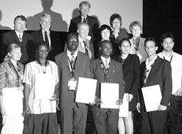
| Prem Chhetri | India | Mapping the potential of scenic views for the Grampians National park |
| Etien Koua | Côte d’Ivoire | Using self-organised maps for information visualization |
| Giedre Beconyte | Lithuania | Twelve years of thematic cartography in Lithuania |
| Nnabugwu O Uluocha | Nigeria | Interfacing indigenous knowledge and GIS for suitable rural mapping and development |
| Felicia I Akinyemi | Nigeria | Mapping selected human development indicators in sub-saharan Africa |
| Henrik Hargitai | Hungary | Planetary maps for public and educational outreach |
| Tatiana Delgado Fernández | Cuba | Service-centric approach to discover spatial information in GSDI |
| Rafael Cruz Iglesias | Cuba | Development of a platform for storage and handling of geographical information in the Internet |
