


At the 25th International Cartography Conference in Paris, France, the Guide Map of Karaj Municipality won the second jury’s prize in the category “Maps and Plans of Towns and Urban Areas”. The jury stated:
Colourful and well-designed informative map.
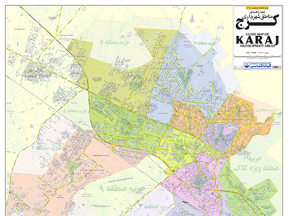


Publisher’s Description: The Guide Map of Karaj Municipality was printed for the first time in Iran by Gitashenasi Geographical and Cartographic Institute in English & Persian text in the scale of 1:19,000 by a team of 4 cartographers in 2010.
In general, the map is made using a greater and more complete map made in the scale of 1:10,000 in Freehand format and printed in the scale of 1:13,000 in the size of 140x200cm under the title of the Complete Map of Karaj Metropolitan.
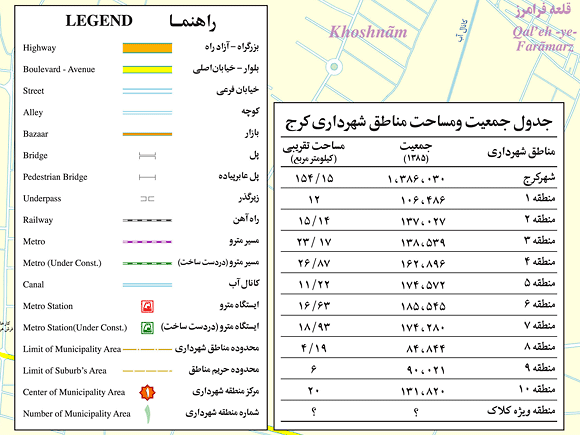
Since 2010 Karaj city was determined as the center of Alborz province and hence is counted as the 31th province of Iran. The said map is made by using satellite images and also the 1:2,000 map series of the Statistic Center of Iran within 14 months by technical section of Gitashenasi Institute and all the new names of highways, avenues, streets were controlled and resounded and corrected on the map 1:2,000. In this map we can see the 10 municipality areas in distinct colors and on the edge of the map at the bottom there is a table containing the population and land area features.
- Paper
- Dimensions (cm): 100x140 (2 sheets 100x70)
- Scale: 1:19,000
- Published by Gitashenasi Geographical & Cartographic Institute
- Date published: 2010
- Language: Persian & English
