


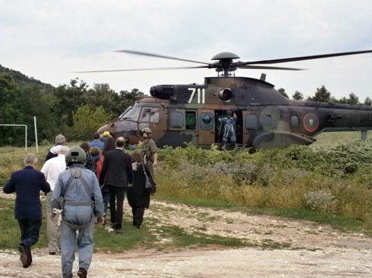
Evacuation of Participants of the 5th Jubilee International Conference on Cartography and GIS with helicopters throught to flash floods in the region of Varna in June 2014
The ICA Commission on Cartography in Early Warning and Disaster Management, chaired by Prof Milan Konecny, has contributed in the past to publications such as the UN-OOSA and JBGIS publication on “Geoinformation for Disaster and Risk Management”, demonstrating the strong need and demand for profound expertise in such contexts.
It happens to be, that the Conference demonstrated this connection unexpectedly. During the Gala dinner, which was organised in a typical Bulgarian restaurant, strong flash floods struck the region. The floods blocked several cities (in Varna city 12 people lost their lives). The only access to the road back to Riviera was closed due to rise in rivers’ water levels. Unexpectedly, participants had to spend the night in the manor without their personal belongings and medicines and with limited food reserves. Emergency services in Bulgaria and various embassies and medical centres were immediately contacted. Finally, with the help of the Military Geographic Service of Bulgaria all participants were evacuated via helicopters and returned safely back to their hotels.
This real life experience demonstrated, that the topic of “Disaster Management and Cartography” can’t be underestimated in its relevance to all of us.
