Welcome to the International Cartographic Association
Welcome to the website of the International Cartographic AssociationGet to know the new ICA Executive Committee for the term 2023-2027
Welcome to the website of the International Cartographic Association
Get to know the new ICA Executive Committee for the term 2023-2027

President’s Blog: Geo4All

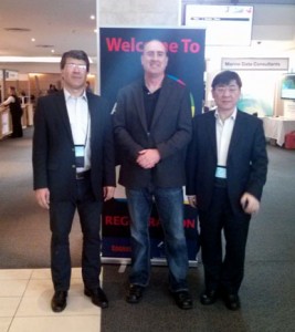
Prof. Chen Jun (ISPRS President), Jeff McKenna (OSGeo President) and Prof. Georg Gartner (ICA President) during their meeting at AfricaGEO in Cape Town in July 2014 to discuss future collaboration for GeoforAll

Prof. Chen Jun (ISPRS President), Jeff McKenna (OSGeo President) and Prof. Georg Gartner (ICA President) during their meeting at AfricaGEO in Cape Town in July 2014 to discuss future collaboration for GeoforAll

The “Geo for All” Initiative has developed out of the Memorandum of Understanding Activities between ICA and OSGeo (the Open Source Geospatial Foundation). So-called “ICA-OSGeo Labs” have been founded in unexpected high numbers in the last months (http://www.geoforall.org/locations/), demonstrating the great interest and demand for evaluating and using Open Source Software in the area of Cartography, GI Science and Geospatial Information Management.

In order to direct the development of this initiative an Advisory Board has been found, co-chaired by the Presidents of ICA (Georg Gartner) and OSGeo (Jeff McKenna). Due to the inclusive character of this initiative and a strong interest being expressed several times from the International Society for Photogrammetry and Remote Sensing (ISPRS) is now joining this initiative.

We are looking forward to working together in our common aim to expand geospatial education and opportunities to all.

Introducing the ICA-OSGeo Lab Network

After discussing with our lab members, I am pleased to inform that we now have the official name and also a short acronym for our network of Open Source geospatial laboratories: ICA-OSGeo Lab Network is the official title of the network and OSGL as the acronym to be used for the url, domain name, etc.

The official full title highlights and brings together two communities – the ICA and the OSGeo (Open Source Geospatial Foundation) – in our common aim to support the establishment of Open Source Geospatial Laboratories and Research Centers across the world for supporting development of open-source geospatial software technologies, training and expertise. We started establishing the network of labs globally with the ICA-OSGeo MoU initiative.

Individual labs (those already established and those in future) are free to select the names they wish. For example, the lab at UNMC is called Open-source Geospatial Research Lab, at NCSU it is OSGeo Research and Education Laboratory (OSGeoREL), it is Open Source Geospatial Lab in Newcastle University, etc. That will also give individual nodes the flexibility to select the name for their lab that they want under a joint lab network umbrella.

We are also working to create a dedicated website and mailing list. In the meantime, visit the OSGeo page on education intiatives for details.

We would like to thank the whole OSGeo and ICA community for the strong support and helping spreading the message of our education initiative.

Best wishes,
Dr Suchith Anand
rawboned-refined