Welcome to the International Cartographic Association
Welcome to the website of the International Cartographic AssociationGet to know the new ICA Executive Committee for the term 2023-2027
Welcome to the website of the International Cartographic Association
Get to know the new ICA Executive Committee for the term 2023-2027

President’s Blog: Inside an EC Meeting

The Executive Committee (EC) of the ICA is meeting twice a year to discuss related issues, analyse the performance of the instruments of the organisation and make operational and strategic decisions. But how does an EC meeting work? I want to give you some insight from my subjective perspective.

The meeting dates are set nearly a year beforehand to make sure that most of the ten members of the EC can make it. There are three central roles in preparing an EC meeting: the local host, which takes care of all arrangements needed to host the EC; the Secretary-General, which sets up the agenda, collects all necessary documents and sends hundreds of emails to communicate with all colleagues; and the president, which tries to steer the EC into the currently most important issues by prioritizing the agenda and asking for input, opinions, decisions and allowing and aggregating discussions.

Usually there are a lot of constraints to consider when scheduling such a meeting; most of them have something to do with the “bread jobs” of the EC members. That’s why not all are arriving at the same day and eventually will not leave with the same flight as well. Thus, time is always short and a “quick” start into the agenda is needed to make sure that the time is well used.

The rooms the EC uses for its meetings have something in common, which I would describe as “no-frills” – nothing to distract the colleagues from their work. However, WiFi and a projector are requirements our Secretary-General is insisting on; some of the colleagues – including myself – would add coffee to this basic requirement list 🙂

The dynamics of such a meeting are always heterogeneous and hard to predict.  There are routine items to discuss, which eventually take much longer than expected. There might be controversial items to discuss, which are on the agenda since years, which all of a sudden are noted and acclaimed.  This has to do with understanding the EC as a group of persons finding themselves in a permanent process about their views, perspectives and shared and common understandings, rather than in unalterable fixed positions. For this reason major issues of core concern to the ICA – such as commissions, conferences, research directions or publications – are regularly put up for discussion. These discussions are not always leading to the same results but rather reflect that process as well.

Usually, an EC Meeting is accompanied with visits or meetings with representatives of the local host country. This allows interesting insights into the local activities and interests as well as the possibility to socialize with our hosts.

Impression of the last EC meeting in Rio de Janeiro

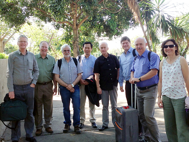
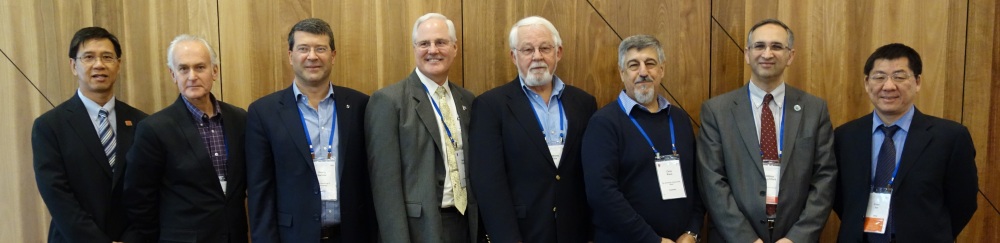
Impression of the last EC meeting in Rio de Janeiro. From left to right: Menno-Jan Kraak, Tim Trainor, Paulo Menezes, Yaolin Liu, William Cartwright, Derek Clarke, Laszlo Zentai and Anne Ruas

As in every group, also an EC meeting develops group dynamics: There are some who are reluctant, some who are cautious, some who are focused, some who are very well organised and prepared and some, who need the inspiration of the meeting itself to order their thoughts and opinions.

It is amazing to see that there can be a tough discussion with very emotional and opposing arguments but a friendly, calm atmosphere right after that. It is amazing to see that there can be fun and jokes and sharing of stories of private life as well. It is amazing to see, that what all EC members have in common, is their commitment towards cartography and their belief in the importance of the International Cartographic Association. They take responsibility, not because they have been forced to do so, but because they are convinced of the importance of being an EC member. Some of them spend private money and dedicate precious time, which they need to be prepared to argue when they are asked from their boss to justify such a travel. Most of them have leading roles in their respective professional backgrounds and are still able to make themselves available for all kind of roles which might be needed in a volunteer organisation.

They, this is Secretary-General Laszlo Zentai, Past-President William Cartwright, Vice-Presidents Anne Ruas, Derek Clarke, Tim Trainor, Menno-Jan Kraak, Yaolin Liu, Paulo Menezes and Sukendra Martha.

– Georg Gartner

President’s Blog: Rio is prepared!

Rio awaits you for the ICC2015!

The deadline for submitting papers for the upcoming International Cartographic Conference 2015 in Rio de Janeiro, Brasil, has passed. We are excited to see that an unexpected high number of submissions have been received!

Now the Scientific Committee under the chairmanship of Prof Claudia Robbi Sluter (University of Parana) will look into the quality of the submissions by reviewing every single entry. With this a selection of submissions to the various publication media including Journals, Book and Proceedings will be proposed and authors will get feedback on how they can improve their submissions. Altogether we all can expect a great programme with exciting contributions and sessions, which fits into the impression the Executive Committee just recently got, when they visited the site of the conference and Rio de Janeiro. Our Brazilian Colleagues are working hard, professional and committed. Also the website of the City Administration of Rio de Janeiro is reporting about the visit: ICC 2015 is seen as the highlight for the city inbetween the World Soccer Cup 2014 and the Olympic Games 2016!

Make sure your company, your institution and of course yourself is present at next year’s ICC 2015!

– Georg Gartner

President’s Blog: International Journal of Cartography (IJC)

Cover of the International Journal of CartographyThe International Cartographic Association (ICA) has partnered with Taylor and Francis to establish a new international journal that will promote research in the fields of Cartography and GI Science: The International Journal of Cartography (IJC).

The ICA sees this partnership and the provision of a quality international peer-reviewed journal as an important tool that will contribute to the ICA’s goal of advancing Cartography and GI Science.

The ICA has taken an initiative to establish the International Journal of Cartography (IJC) to provide the international research community with a vehicle to report and disseminate the outcomes of research in our wide field of endeavours.

The journal is co-edited by William Cartwright and Anne Ruas. It has 4 Associate Editors: Lynn Usery, Gennady Andrienko, Elri Liebenberg and Zhilin Li – and an international advisory board.

All submissions and reviewing for papers submitted to the International Journal of Cartography are handled electronically through the Taylor and Francis online facility. This facility manages the paper-handling process from submission, to review and revision to publishing.

To submit a manuscript for consideration, authors should access the journal website at: http://www.edmgr.com/tica/

Thank you in advance for your future support of the International Journal of Cartography!

– Georg Gartner

Obituary: Ramón Lorenzo Martínez

Ramón Lorenzo Martínez

Ramón Lorenzo Martínez (photo by SECFT)

It is with great sorrow that ICA received the sad news that Mr. Ramón Lorenzo Martínez passed away.

Mr. Ramón Lorenzo Martínez was a distinguished engineer and cartographer. He was the first director of the Regional Service of the National Geographical Institute in Galicia (A Coruña). He served further in the National Center for Geographic Information in Madrid, Spain and as Director of the Publication Centre of the Spanish Ministry of Public Works.

Mr. Ramón Lorenzo Martínez was highly respected in the International Cartographic Community. He was one of the faces of Spanish cartography as President of the Spanish Society of Cartography, Photogrammetry and Remote Sensing (SECFT) since 1996 and very well established within the International Cartographic Association (ICA) through his various roles in the Executive Committee (as Vice-President of the ICA from 2003 to 2007), in the conference organisation of the 22th International Cartographic Conference in La Coruna 2005, as well as most competent cartographer.

We will honour his memory.

Category: General News

President’s Blog: JBGIS

The International Cartographic Association has close relationships to neighbouring domains and their international organisations, we even call them sister societies. This goes as far as having joint activities, including e.g.

  • a Joint Working Group on Toponomy with IGU,
  • an International Board for Standards of Competence (IBSC) of FIG, IHO and ICA,
  • joint sessions at the vice versa conferences with the International Society for Photogrammetry and Remote Sensing (ISPRS),
  • joined interests and participation at the events of the International Steering Committee for Global Mapping (ISCGM), the International Map Industry Association (IMIA), the International Association of Geodesy (IAG) or the Global Spatial Data Infrastructure Association (GSDI).

All those organizations have their particular aims and scope, interests and activities. But all of them have also an interest to cooperate and eventually synchronize activities. This is the role of JBGIS.

The Joint Board of Geospatial Information Societies (JBGIS)

Members of the Joint Board of Geospatial Information Societies in 2012

Members of the Joint Board of Geospatial Information Societies in 2012


JBGIS logoJBGIS is a coalition of recognized international geospatial organizations involved in the coordination, development, management, standardization or regulation of geospatial information and related matters, represented by the presidents, secretary‐generals or equivalent office bearers or their nominees that lead those organizations.

This coalition becomes especially important when the “geo domains” being represented in the JBGIS need to find one voice, as e.g. in the context of United Nation activities or other international and interdisciplinary frameworks. It is therefore of importance to ICA, that the JBGIS is recognized by the United Nations Initiative on Global Geospatial Information Management (UN-GGIM).

William Cartwright

Former JBGIS chair William Cartwright

The JBGIS chair position rotates between the member organizations. It happens to be, that our Past President William Cartwright was elected chair of the JBGIS 2011. Due to the fact, that his leadership was unanimously perceived as crucial for the further development of JBGIS he was asked to prolongate his term as chairs twice until 2014, which was an exceptionally affair, giving him as well as ICA a most prominent profile in this respect.

In the latest JBGIS Meeting in August 2014 the chair position of William Cartwright was taken over by IAG President Chris Rizos. I would like to take the opportunity to express my sincere thanks to Past-President William Cartwright for his excellent work in this respect.

Georg Gartner
President of the International Cartographic Association

President’s Blog: ICA Research Scholarships

Are you a young scientist?
Is your research topic linkable with the ICA Research Agenda and an ICA Commission?
Do you need support?

I would like to point your interest to a new instrument of ICA, the ICA Research Scholarships.

With this we would like to reach the following aims:

  • to foster academic research in the domain of Cartography and GIScience
  • to establish contact between young scientists and ICA Commissions
  • to support young scientists to be able to actively contribute to ICA activities and events, such as especially International Cartographic Conferences
  • to establish opportunities for young scientists within ICA publications and conferences

Interested? Information about how to apply can be found in the document
ICA Research Scholarships 2014/2015.

We are looking forward to hear from you!

Georg Gartner
President of the International Cartographic Association

President’s Blog: Breaking News – ICA accepted as full ICSU member

Logo of the International Council for ScienceIt is my sincere pleasure to announce, that at her 31th General Assembly the International Council of Science (ICSU) has accepted the International Cartographic Association as a Full International Scientific Union Member.

ICSU’s mission is to strengthen international science for the benefit of society. The International Council for Science (ICSU) is an international non-governmental organization devoted to international cooperation in the advancement of science. Its members are national scientific bodies and international scientific unions. It comprises 120 multi-disciplinary National Scientific Members representing 140 countries and 31 international, disciplinary Scientific Unions.

From now on ICSU has 32 International Scientific Union Members, giving Cartography through ICA a strong voice in the world of science.

Georg Gartner
President of the International Cartographic Association


Further information:

 
Update: As of July 2018, ICSU has become the ISC (International Science Council) through the merger with the International Social Science Council (ISSC).

President’s Blog: Education

Cartography is a domain including technology, art and science. In order to be able to fully deploy the capacity of cartography education in all these areas is key. It happens to be that respective university programmes, professional trainings, and job trainings are more and more changing their scopes and names, leaving the unique competence combination of cartographers, being able to deal with big data, modern technologies and artistic design, vacant.

It is of this reason, that programmes dealing with dedicated cartographic education are of growing importance. Let me highlight here two programmes, which ICA is taking significant note of.

  • The International Course on Management and Applied Techniques in Cartography (IC_Cartotechnology), run by the Institut Cartografic i Geològic de Catalunya, has the aim to provide a wide range of geoinformation professionals with a capacity-building instrument that covers the basis of advanced and up-to-date techniques, tools and critical thinking in cartography. It therefore integrates all the disciplines, approaches and techniques used to acquire and exploit geospatial data. Several ICA collegues have contributed to the first successful edition by giving lectures. The second edition starts in September 2014 and enrolment is still possible.
  • Three central european universities, the Technical University Munich, the Vienna University of Technology and the Technical University Dresden, are offering a joint Master Programme on Cartography. This is a 4-semester programme and it leads into a joint master degree of all three universities. Currently four intakes have been accepted and are in different stages of their studies. The programme is competitive, as only a restricted number of students can be accepted and has so far proven to be most successful in achieving the aim of educating experts with capacity in technologies, data handling and design skills.

President’s Blog: International Map Year 2015–2016

Logo of the International Map Year 2015/2016

It is my sincere pleasure to inform you that at the fourth session of the United Nations Committee of Experts on Global Geospatial Information Management at the UN Headquarters in New York, 6–8 August 2014, the ICA Initiative on an International Map Year 2015–2016 was positively discussed.

The resolution states:

The committee endorses the International Map Year 2015–2016 as proposed by the International Cartographic Association as a valuable means to promote the importance of maps and geoinformation.

With this we have reached a most prominent framework for the planned acitivities and I invite all members of the ICA family to consider their active participation. To stay up-to-date with all activities around the International Map Year, please visit mapyear.org.

Georg Gartner
– President of the International Cartographic Association


rawboned-refined