Welcome to the International Cartographic Association
Welcome to the website of the International Cartographic AssociationGet to know the new ICA Executive Committee for the term 2023-2027
Welcome to the website of the International Cartographic Association
Get to know the new ICA Executive Committee for the term 2023-2027

Registration open for “Conquering the World through Cartography”

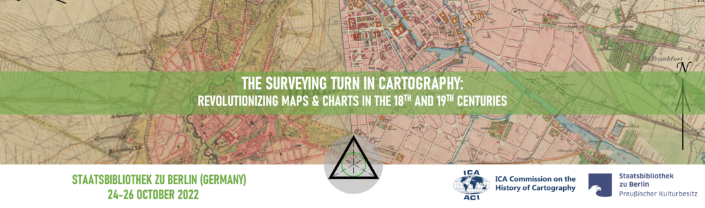
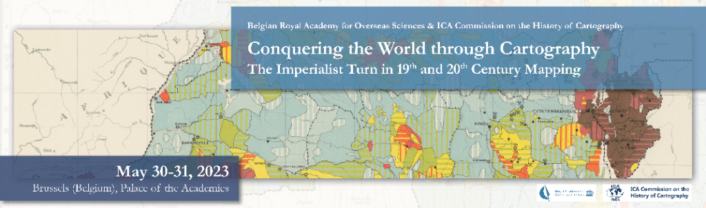
From Tuesday 30 May till Wednesday 31 May 2023 the ICA Commission on the History of Cartography and the Belgian Royal Academy for Overseas Sciences will jointly host an international conference on colonial cartography. This will be organized as a hybrid event, both face-to-face at the Palace of the Academies in the centre of Brussels and via livestream.

Theme

The 21st century map image of continents beyond Europe is still decisively shaped by inherited aesthetics and content dating back to the turn from explorative to imperialist cartography. The symposium welcomes contributions (papers and posters) to analyse aspects of the imperialist Global North hegemony by investigating topographic mapping, hydrographic charting, and thematic mapping in personal, institutional, and regional case studies. The regional scope of the conference are overseas continents and seascapes within the time frame from about the Napoleonic wars to the European de-colonization in the mid-twentieth century (1940s to 1960s).

Programme & Registration

A provisional list of accepted oral and poster presentations can be found here.

Please visit history.icaci.org/brussels-2023 for more details and the link to the registration page. The early bird registration deadline is 5 May.

The conference’s scientific programme of lectures will take place all day on Tuesday 30 May and on Wednesday morning 31 May. Optional free tours are planned both on the afternoon of Wednesday 31 May, visiting the map collection of the AfricaMuseum, as well as on the morning of Thursday 1 June, for a visit to the Map room of the Royal Library of Belgium, themed “Not just Congo. Belgian colonial mapping in the 19th and 20th centuries”.

We hope to see many of you there!

Soetkin Vervust
Secretary ICA Commission on the History of Cartography

Tag:

Programme published for “The Surveying Turn in Cartography”

From Monday 24 October till Wednesday 26 October 2022 the ICA Commission on the History of Cartography and the Staatsbibliothek zu Berlin will jointly host the 9th International Symposium on the History of Cartography. The venue will be the recently renovated old main building of the Staatsbibliothek in the heart of Berlin on the boulevard Unter den Linden (subway stop) within sight of the iconic Brandenburg Gate. To explore the city and its cartographic heritage, tours of the Staatsbibliothek and the Humboldt-forum’s map collections, as well as a guided walking tour of the city are planned.

Programme

The full programme has been published and can be accessed here.

It promises to be an exciting event at a wonderful venue! Registration (55 euro) is still possible through the website: https://history.icaci.org/berlin-2022/

We hope to see many of you there!

Soetkin Vervust
Secretary ICA Commission on the History of Cartography

Tag:

Call for Papers for the 9th International Symposium on the History of Cartography

The International Cartographic Association’s Commission on the History of Cartography and the Staatsbibliothek zu Berlin (Berlin State Library) will jointly host the 9th International Symposium on the History of Cartography on the topic of The Surveying Turn in Cartography: Revolutionizing Maps & Charts in the 18th and 19th Centuries on 24-26 October 2022.

Theme

The joint organizers encourage contributions investigating the global “surveying turn” in cartography, hinting to the increasing professionalization and mechanization to gather base data for drawing ‘ever truer to nature’ maps, especially during, but not limited to, the eighteenth and nineteenth centuries.

Call for Papers

The organizers invite the submission of abstracts for papers and posters. These need to reach the organisers by the 1st of June 2022. You can submit your abstract here.

Registration

Registration will open in the summer of 2022.

For more information visit the conference website: history.icaci.org/berlin-2022/

Tag:

Call for Papers: Coordinating Cartographic Collections

On 30 September 2021 the ICA Commission on the History of Cartography is organizing the online workshop “Coordinating Cartographic Collections”, in conjunction with the 12th Virginia Garrett Lectures on the History of Cartography (University of Texas at Arlington) and the Fall Meeting of the Texas Map Society.

The ICA Workshop, due to the varying international Covid19 situation and travel restrictions, will be an ONLINE EVENT. The 12th Virginia Garrett Lectures & Fall Meeting of the Texas Map Society, however, are planned as a HYBRID CONFERENCE from 1 to 3 October 2021 (in-person attendance and online streaming). Presenters and registered participants of the ICA Workshop will get FREE online access to this conference as well.

Call for Papers

All three connected events are exploring the incredibly diverse cosmos of maps in collections. The ICA Workshop invites personal and institutional case studies / best practice examples on the following topics (though other contributions will be considered as well):

  • collecting (trade and collector)
  • cataloguing
  • preserving
  • presenting (physical and digital)
  • access / user perspectives
  • managing (back office)

Deadline for submission of abstracts: 30 July 2021
Notification of acceptance: 13 August 2021
Guidance on abstracts: min. 200 words – max. 500 words, add a brief biographical note

Inquiries and submissions should be directed to:
Prof. Dr. Imre Josef DemhardtChair ICA Commission on the History of Cartography

Tag:

Invitation to the 8th International Symposium on the History of Cartography: Mapping the Ottoman Realm

Cover picture of the 8th International Symposium on the History of Cartography

In two months the 8th International Symposium of the ICA Commission on the History of Cartography will convene in Istanbul (Turkey). The online registration is now open. Detailed information is available on the conference website (https://history.icaci.org/istanbul-2020/), including:

  • list of 38 accepted presentations
  • link to register online
  • zoomable map to locate the venue in the heart of Istanbul

The Symposium is open to everyone with an interest in the cartography of the (former) Ottoman countries in Europe, Asia and Africa as well as the mapping of archaeological sites, landscapes and excavations. The Symposium is jointly hosted by the ICA Commission on the History of Cartography and the German Archaeological Institute (DAI) – Department Istanbul.

Questions can be directed to:

Tag: ,

Call for Papers for the 8th International Symposium on the History of Cartography: Mapping the Ottoman Realm / Proceedings

The ICA Commission on the History of Cartography will be holding its 8th International Symposium from 21 to 23 April 2020 in Istanbul. We have teamed up with the German Archaeological Institute (DAI) – Istanbul Department to host this conference on the theme of ‘Mapping the Ottoman Realm: Travelers, Cartographers and Archaeologists’ and look forward to receiving your contributions. 

Cover picture of the 8th International Symposium on the History of Cartography

We are delighted to announce that professor Celâl Şengör from the Istanbul Technical University will deliver a keynote address on “Geological mapping in the Ottoman Empire and in the early years of the Turkish Republic. What do they teach us about science in the periphery of Europe.”

You can find the abstract of the keynote, the CfP and more information on the symposium by visiting the symposium website at history.icaci.org/istanbul-2020. Please note the paper deadline is 1 November 2019.

In further news, the proceedings of our previous symposium on ‘Mapping Empires: Colonial Cartographies of Land and Sea’ which was held in Oxford in September 2018 have recently been published by Springer. You can find them here: springer.com/us/book/9783030234461

Soetkin Vervust
Secretary ICA Commission on the History of Cartography

Tag: ,

Congratulations to the ICA scholarship awardees at ICC2019 and pre-conference workshops

The goal of ICA Scholarships is to stimulate young scientists or professionals to direct their careers toward fundamental studies in the fields of Cartography and GISciences. The following scholarships were awarded for participation in the ICC2019 and pre-conference workshops.

Scholars at ICC2019

ScholarTitle of paper / poster
Nargiz Safaraliyeva, AzerbaijanTeaching basic map concepts in three countries: Azerbaijan, Hungary and United Arab Emirates
Malak Alasli, MoroccoToponyms’ contribution to identity: The case study of Rabat (Morocco) | Static Risk Mapping of Forest Fires – In the case of the Province of Chefchaouen (Morocco)
Shyamantha SUBASINGHE, Sri LankaUrban Growth: From pixel to reality
Dr. Alena Vondráková, Czech RepublicTouchIt3D: Technology (not only) for Tactile Maps | The Specifics of Cartographic Semiology in Tactile Maps
Ashna Kareem Zada, IraqTesting Maps for Visually Impaired People in Kurdistan
Jagadish B, IndiaDeriving Multiple Representation Database: A Model Generalisation Approach
Lukasz Halik, PolandTeaching of geographical space relations for cartography – Academic Outdoor Station in Poznan (Poland) | Workflow for 3D geovisualization of the data obtained with the use of Unmanned Aerial Vehicle in Augmented Reality | The visualization of the use of land on the basis of the dynamics of the pedestrian movement from the interval UAV imaging | Measuring user preferences in virtual reality (VR): 2D versus 3D urban geovisualizations of topographic data
Márton Pál, HungaryDigital cartography for geoheritage: turning an analogue geotourist map into digital | Possibilities of high precision GPS data in autonomous driving
Nikola Yonov, BulgariaSchool Atlas with Augmented Reality
Radek Barvir, Czech RepublicThe Specifics of Cartographic Semiology in Tactile Maps | TouchIt3D: Technology (not only) for Tactile Maps
Pongpichaya William Limpisathian, USA/ThailandRepresentations of Place in the Human Brain
Ivan Evgenyevich Fokin, RussiaThe automation of processes of atlas mapping | Methods and algorithms for creation of structural schemes of rivers
Nick Lally, USAMapping dynamic, non-Euclidean spaces | Interactive & Multiscale Thematic Maps: A Preliminary Study
Xiao Huang, USA/ChinaLinking picture with text: tagging flood relevant tweets for rapid flood inundation mapping
Carolyn S. Fish, USAEmotional responses to climate change map framing using facial emotion recognition technology
Harrison Cole, USAToward Accessible Hazard Mapping: Tactile Risk Maps and Disaster Preparedness
Laure De Cock, BelgiumLinking perception to decision point complexity for adaptive indoor wayfinding support
Maja Kalinic, Germany/Bosnia-HerzegovinaFloating Car Data and Fuzzy Logic for classifying congestion indexes in the city of Shanghai
Ross Thorn, USAHow to Play with Maps

Scholars at pre-conference workshops

ScholarWorkshopTitle of paper / poster
Aytaç YÜRÜKÇÜ, TurkeyHistory of Cartography and the Topographic MappingHow East and West Cartographic Studies Influenced the Most Important 16th Century Ottoman Cartographer of Piri Reis and His World Maps
Dr. Lei ZOU, USALocBigData 2019Leveraging Location-Based Social Media for Smart Emergency Management
Christian RÖGER, GermanyLocBigData 2019Visualizing the Complexity of Crossings using Star-Plot Maps
Wangshu WANG, AustriaJoint Pre-Conference Workshop of the ICA Commission on Use, Users, and Usability, the Commission on Cognitive Visualization, the Commission on Location-based Services and the Commission on Visual AnalyticsTowards a Functional Ontology for Mobile Map Applications

From left to right: Márton Pál, Nick Lally, Pongpichaya William Limpisathian, Radek Barvir, Malak Alasli, Dr. Alena Vondráková, Shyamantha Subasinghe, Ashna Kareem Zada, Harrison Cole, Maja Kalinic, Laure De Cock, Carolyn S. Fish, Nikola Yonov, Lukasz Halik, Ivan Evgenyevich Fokin, Jagadish B, Xiao Huang

From left to right: Christian Röger (pre-conference), Wangshu Wang (pre-conference), Nargiz Safaraliyeva (ICC), Dr. Lei ZOU (pre-conference)

Left: Aytaç YÜRÜKÇÜ, Pre-conference; Right: Ross Thorn, ICC


Congratulations to all scholars!

Invitation to Pre-ICC Workshop on Cartography as a Cultural Encounter: How East and West have Mapped and Influenced Each Other

The ICA Commission on the History of Cartography and ICA Commission on Topographic Mapping take pleasure in inviting you to their jointly organised workshop held before the 29th International Cartographic Conference on 15 July 2019.

Location: National Museum of Emerging Science and Innovation (Miraikan), Room Uranus

Programme

The workshop programme is provisional and might be subject to change. Check the workshop website for updates.

  • 10:00–10:15 Walk in with coffee/tea
  • 10:15–10:30 Opening address by the organizers 

Session I – Eastern Cartographic Practices and their Echo in the West

  • 10:30–11:05 World image of early modern Japan, Professor Hirotada Kawamura
  • 11:05–11:40 Early modern maps of Japan as sources of Western cartography of East Asia during the 18th and 19th century, Professor Shigeru Kobayashi
  • 11:40–12:15 Early Chinese Bronze Ritual Vessel Cartography: How Trees, Mounds, Spirals, and Ponds Were Used to Document Early China’s Landscape, Bruce Jones

12:15–13:30 Lunch break (on your own)

Session II – From Tradition to Modernity: Diverse Cartographic Cultures in India

  • 13:30–14:05 Cartographic history of India: Mapping India from the early modern ages till 20th century, Ankita Medhi
  • 14:05–14:40 The role of cartography in tiger conservation of Ranthambhore Tiger Reserve, India, Bhanwar Vishvendra Raj Singh

14:40–15:00 Coffee break

Session III – Between the Old and The New World: A Cartographic Encounter

  • 15:00–15:35 How East and West Cartographic Studies Influenced the Most Important 16th Century Ottoman Cartographer of Piri Reis and His World Maps, Aytaç Yürükçü
  • 15:35–16.05 Jesuit View of Americas: A Cultural Encounter in the New World, Mirela Altić
  • 16:05–16:15 Closing remarks


Map Exhibitions

Two exhibitions concerned with the history of cartography are being held during the ICC in Tokyo. The first is an exhibit at the National Diet Library (NDL) located in the central part of Tokyo. On display are seven sets of maps which were selected from the collection of NDL as notable examples of Japanese early modern maps. Second is a special exhibition of maps of Japan by Sekisui Nagakubo (1717-1801) focusing on the role of his maps in the transition of the Western geographical image of Japan when they were brought to Europe. The exhibit is being held at the Koga Historical Museum, Koga City, Ibaraki Prefecture.

Both exhibitions are announced on the ICC homepage as Technical Visits on Wednesday 17 July as T-Course B. For more information on the exhibitions see http://www.icc2019.org/technical_visits.html


Please find more information on the workshop website: history.icaci.org/tokyo-2019

Save the Date & Call for Papers for the 8th International Symposium on the History of Cartography: Mapping the Ottoman Realm

On 21-23 April 2020 the ICA Commission on the History of Cartography and the German Archaeological Institute (DAI) – Department Istanbul will jointly host the 8th International Symposium on the History of Cartography. The venue will be the Library of the DAI, located in the heart of Istanbul, next to Taksim Square.

Cover picture of the 8th International Symposium on the History of Cartography

Since its massive expansion under Sultans Selim I (1512-20) and Suleiman the Magnificent (1520-66), the Ottoman Empire extended from the Algerian shores to Georgia in the Caucasus and from Hungary in the heart of Europe to Yemen on the shores of the Indian Ocean. Albeit in a long decline thereafter, the core of this multi-cultural conglomerate survived into the early 20th century, before it finally disintegrated after World War I. Throughout these five centuries, the Ottomans deeply influenced these heterogeneous countries with at times closer or looser ties to the metropolis Constantinople, leaving a multi-faceted cartographic legacy behind.

The symposium is open to everyone with an interest in the cartography of the (former) Ottoman countries during, but not limited to, the 16th to 20th centuries. The symposium will focus on two main themes:

1) “Cartography of the Ottoman Countries in Europe, Asia and Africa”

  • Ottoman cartography (maps and charts, city and cadastral plans, thematic maps)
  • Foreign cartography of Ottoman countries
  • Geodesy and surveying methods developed under Ottoman rule and by foreign cartographers working in these areas
  • The impact of the military on the development of cartography
  • Cartographic collections in the former Ottoman countries and around the world

2) “Mapping Archaeological Sites, Landscapes and Excavations in the Ottoman Empire in the 19th and 20th Centuries”

  • Technical and conceptual development of archaeological cartography, from the earliest site plans to the introduction of GIS and 3D reconstructions
  • Dichotomy between “accurate” cartographic representation and archaeological interpretation when mapping manmade artefacts, features and landscapes
  • Relationship between cartography, archaeology and the military

The venue of the 8th International Symposium on the History of Cartography will be the Library of the German Archaeological Institute in Istanbul in the heart of the city next to Taksim Square. To explore the city and its cartographic heritage, optional technical and social tours are planned.

Submission guidelines

  • Deadline for submissions: 1 November 2019
  • Notification of acceptance: 30 November 2019

All submissions must be sent electronically via the online submission system on the conference website. Please find all details here.

As with previous international symposia the organizers plan to publish accepted and presented papers and posters in the ICA series “History of Cartography” by Springer (Heidelberg et al.).

Questions regarding submissions can be addressed to:

The event is jointly organized by the ICA Commission on the History of Cartography and the German Archaeological Institute (DAI), Department Istanbul. For more information on the symposium and for the submission of abstracts please visit history.icaci.org/istanbul-2020.

Tag: ,

Announcement of the Pre-ICC Workshop on Cartography as a Cultural Encounter: How East and West have Mapped and Influenced Each Other

The ICA Commission on the History of Cartography and ICA Commission on Topographic Mapping take pleasure in inviting you to their joint international preconference workshop: Cartography as a Cultural Encounter: How East and West have Mapped and Influenced Each Other. The workshop will be held at the National Museum of Emerging Science and Innovation, on 15 July 2019. The workshop is open to all cartographers, geographers, historians, map collectors, academics and lay persons interested in the diverse aspects of the history of cartography and topographic mapping.

The joint organizers invite papers on both western and eastern cartographic practice from a historical perspective, from the early modern era until the early 20th century. Themes include how each of these cartographic traditions developed over time, how they understood and mapped their own space but also how they mapped and saw Others, and how these diverse cartographic cultures and practices around the globe contributed to the dissemination of geographic knowledge.

Although the Symposium will primarily focus on these themes, submissions of high quality on endeavors in other fields of cartographic history and topographic mapping will also be considered.

Venue

The intended venue is the National Museum of Emerging Science and Innovation, located in the beautiful Tokyo bay area. The Museum is equipped with an excellent space for our conference sessions, map exhibition and technical exhibition. The conference venue is surrounded by more than 3 000 hotel rooms within walking distance.

Call for Papers

The organizers invite the submission of abstracts for oral presentations (25 min + 5 min for questions and discussion). These need to reach the organisers by 30 March 2019. You can submit your abstract here.

Registration

The workshop is open to everyone with an interest in the history of cartography and topographic mapping but requires participants to register. Registration will be open until the available seating is allocated and is free of charge. Please note that it is not necessary to be registered for the main ICC conference to be able to attend the workshop. You can register for the workshop here.

Contact

Questions regarding the workshop can be directed to:

  • Mirela Altic – Vice-Chair ICA Commission on the History of Cartography: mirela.altic(at)gmail.com
  • Alexander Kent – Chair ICA Commission on Topographic Mapping: alexander.kent(at)canterbury.ac.uk


Please find more information on the workshop website: history.icaci.org/tokyo-2019

rawboned-refined