THE DIGITAL WATERMARKING METHOD OF VECTOR GEO-DATA BASED ON
WAVELET TRANSFORMATION
C.Q. Zhu, C.S. Yang
Zhengzhou Institute of Surveying and Mappingy, Zhengzhou,
China
zcq88@263.net
Geo-spatial data are the supporting production of national
infrastructure construction and the research of geoscience. The security issue
of geo-spatial data refers to state security, science and technology
cooperation and copyright protection. At present, there must have a credible
technique to secure the geo-spatial data.
The digital
watermarking is a new developed former technology of information security.
There have been many applications for digital watermarking in many fields such
as digital images, video, audio and so on. For the Geo-data there were few
studies on the digital watermarking.
In the paper, a digital
watermarking method using wavelet transformation for the digital vector
Geo-data is developed. By
the proposed method, the line and surface coordinate points are decomposed by
wavelet transformation firstly, then the digital watermarking is embedded in
the low frequency coefficients of wavelet transformation, and the vector
geo-data with watermarking is obtained by inverse wavelet transformation
finally.
The main steps of
the proposed digital watermarking method for vector Geo-data include the
watermarking embedding algorithm and watermarking detecting algorithm.
The basic flow of embedding
watermarking for Geo-data is shown in Figure 1.
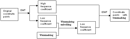
Figure 1. The
basic flow of embedding watermarking
The basic flow of
the detecting watermarking is shown as Figure 3.
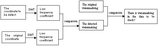
Figure 3. The
flow of detection watermarking
Further, we experiments the proposed digital watermarking method by a digital contour
including 348750 coordinate points with scale 1:250000. The results show that the proposed watermarking method
can resist the attacking such as noise, adding points, deleting points and
removing points. Hence the proposed method is with high robustness, so it can
be used to secure the security
of vector Geo-data widely.