


The 23th International Cartographic Conference
took place in Moscow, Russia, 4–10 August 2007.
Proceedings
Proceedings of the conference can be found here (external link).
General Assembly
The conference hosted the 14th General Assembly of the ICA.
Minutes (in English an French)
International Cartographic Exhibition
In total, 27 countries submitted entries for this exhibition. All entries were displayed and lightened in pavilion 69 of the Exhibition Centre. A catalogue was made available to all conference participants. The best products were selected in 9 categories by an international jury with the following members:
- Corné van Elzakker, Chair (The Netherlands)
- Vladimir Zhukovsky (Russia)
- Cynthia Brewer (USA)
- Takashi Morita (Japan)
- Haggai Nyapola (Kenya)
- Philippe DeMaeyer (Belgium)
- Miljenko Lapaine (Croatia)
| Atlases | 1st: Atlas of Moscow, Russia, “Splendid, up-to-date (data from January 2007!) and very complete multimedia representation of Moscow on paper with 2D and 3D maps, anaglyphs, aerial and other photographs, etc.” 1st: National Atlas of Russia. Vol. 2: Nature, ecology, Russia, “Volume 2 of the extensive 15 volumes National Atlas of Russia. Extremely thorough piece of scientific work in the well-known and famous Russian physical geographical tradition.” 2nd: Atlas of Protected Areas of Iran, Iran, “Bi-lingual (Persian and English) well-designed and well-produced atlas which firmly convinces the users of the need to protect natural areas.” 3rd: Estonian Cruising Guide 2006–2007, Estonia, “Atlas of all (small) harbours for yacht sailors in Estonia. For each harbour there is a set of maps at various scales (hydrographic, harbour settlement and hinterland), oblique aerial photographs and text information.” |
| Hydrographic/Nautical Charts | 1st: Central Arctic Basin, Admirality No. 91115, Russia, “Splendid cartographic overview of the Central Arctic Basin with a good colour confrontation.” 2nd: Sankt Anna Archipelago, Sweden, “Very clear and easy-to-read hydrographic map of a complex island area.” 3rd: Korppoo Turku, Finland, “Standard hydrographic map, but with a high standing quality in the representation of a complicated area.” |
| Multimedia | No winners due to technical problems |
| Recreation and Orienteering Maps | 1st: Super bird’s eye view of Asahikawa, Japan, “Very effective annotated virtual reality representation.” 2nd: Cykloatlas Česko, Czech Republic, “User-friendly loose-leaf cycling atlas with all the information required by cyclists, including height profiles and detailed maps and route information.” 3rd: Map and guide of Garajonay National Park, Spain, “Attractive design with a nice representation of the 3rd dimension of the terrain. Deft relief represented with dense contours overlayed by subtle color and texture differences for land cover and land use types. Trails are symbolized with small foot prints in an inviting way that contrasts well with other boundary lines. Label styles are well categorized and slight halos make them readable against detailed park terrain.” |
| Relief Models and Globes | 1st: Physical Globe 1:40,000,000, Russia, “Impressive touchable globe, produced by digital means.” 2nd: Relief model of Catalunya, Spain, “Plastic real 3D relief map with indication of height differences of the sea floor as well.” 3rd: Plastická Mapa Beskydy, Czech Republic, “Good example of a well designd and produced plastic relief model.” |
| Satellite Images / Satellite Image Maps | 1st: Nighttime Lights of the World, USA, “Very didactic representation with an integration of fires and light.” 2nd: From Tärna to Træna, Norway, “Very attractive and appealing satellite image of an area along the Arctic Circle.” 3rd: Moscow from Kosmos, Russia, “Nice integration of remote sensing image and cartographic map.” |
| Thematic Maps | 1st: Carte Géologique harmonisée du département de l’Herault, France, “Well-designed and clear map, with a good colour selection and nice hillshading in the background.” 2nd: Vegetation Map of South Africa, Lesotho and Swaziland, South Africa, “Large map at scale 1:250,000. Map editors have managed to select proper colours for the 435 map units to be represented.” 3rd: Map of Dujiangyan Irrigation Area, China, “Map designers have coped very well with the problem of superimposing various map layers (topography, geological strata, irrigation zones). Traces of streams still appear very clearly.” |
| Topographic Maps | 1st: Topographic map of Aoraki / Mt Cook Alpine Area, New Zealand, “Appealing colours and map design. Good registration on road features. Impressive detailed contouring.” 2nd: National Topographic Map of Campo de Cartagena, Spain, “Example of a well designed and appealing topographical map, which may easily be used for a variety of purposes. Expert use of light textures. Simplified urban block structure establishes road pattern without overpowering design.” 3rd: Topomapa Základni Mapa CR 1:25,000, Czech Republic, “Well designed and produced modern topographic map of high standing. Trail detail meshes well with subtle topographic rendering. Gray and green color use in urban area symbolization is distinctive.” |
| Urban Maps / Town Plans | 1st: Översiktskarta Solna, Sweden, “Beautiful overview map of the town of Solna, obviously based on a user-centered design approach. Well structured use of hues to organize image with brown/ orange/red for urban areas and greens for open areas. The design incorporates detailed hierarchies and shows care in label placement.” 2nd: Irkutsk, Russia, “Modern cartographic representation of the urban area of Irkutsk. The map presents good detail in buildings, and the light colours produce a readable design. Tint bands emphasize boundary locations with an appealing design.” 3rd: Street Directory of Pamplona, Spain, “Well-designed street directory on which measurements can be made easily.” |
| Other | 1st: Geographical Atlas of Europe, Vol. I and II, for blind and visually handicapped people, Poland, “Atlas for blind and visually handicapped people that can also be used by sighted people. Modern production techniques. Complete atlas.” 2nd: Urner Hiking and Bikemap Gotthard, Switzerland, “Mixture of a topographic and recreational map with a very good relief representation, as we know from the Swiss.” 3rd: Map of Census Boundaries, USA, “Map showing the solution to the always difficult problem of showing administrative boundaries for areas at varied levels that nest and intersect, while maintaining contrast with the road and shoreline base information.” |
The IHO award for the best entry at hydrographic charts exhibition was won by Australia, with the 2nd and 3rd prizes for Japan and the Netherlands.
Barbara Petchenik
Below you can find all international winners. To see all exhibited maps, please visit the Winner Map Collection at the Carleton University Library.
Lukas Kareiva (7), Lithuania, < 9 years (public vote)

Bita Porrang (8), Iran, < 9 years

M Yafie Abdillah (8), Indonesia, < 9 years

Samuel Zúñiga Vélez (9), Spain, 9–12 years (public vote)

Alexandra Gavin (11), UK, 9–12 years

Katarzyna Fojcik (11), Poland, 9–12 years (public vote)

Joanna Ivanova Ivanova (12), Bulgaria, 9–12 years

Marta Londzin (13), Poland, 13–15 years

Svitlana Moskalenko (14), Ukraine, 13–15 years

Yasmin Ahmed Ali (14), Qatar, 13–15 years

Rita Galkina (15), Russia, 13–15 years (public vote)

Sama Salah Al Sayed (4), Qatar, special award

Read the PDF report.
Travel Awards
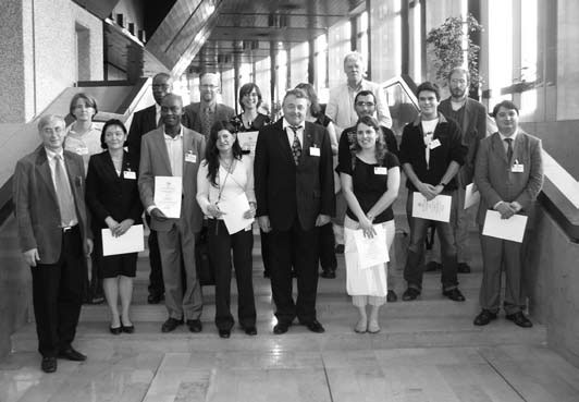
Travel Award recipients with members of the ICA officials
| Leandro Andrei Beser de Deus | Brazil | Images of the past: Colonial Guanabara Bay and European military cartography |
| Mariana Alesia Campos | Argentina | The use of cartographic material in High School: Diagnosis and consequences |
| Ahmet Dogru | Turkey | GIS applications on epidemiology with cartographic perspective in Turkey |
| Kristina Gurjanovaite | Lithuania | Cartographic analysis of general geographic elements in children’s mental maps |
| Henrik Hargitai | Hungary | Localizing the gazetteer of planetary nomenclature |
| Dao Hoai | Vietnam | An approach to visualize big volumes of video |
| Alexander Kent | United Kingdom | An analysis of stylistic diversity in European state 1:50 000 topographic maps |
| Lilla Lukacs | Hungary | Database of Hungarian geographical names |
| Ana Paula Micou | Argentina | Feasibility of installing sustainable urban drainage systems in already urbanized areas of the Calderdale District, West Yorkshire, England |
| Jean Pierre Nghonda | Cameroon | La problematique de la cartographie comme discipline academique et support didactique au Cameroun |
| Gabriel Origel-Guitierrez | Mexico | Digital geosciences: E-journal of interactive on-line maps |
| Natalia Polyakova | Ukraine | Semantic structure of the typical thematic map contents in the geoinformational mapping |
| Teresa Saint Pierre | Argentina | The importance of using contour lines in teaching |
| Malick Ould Vall | Mauretania | Vers la mise à jour cartographique et création de bases de données numériques de la Mauritanie |

2 Responses