


The 31st International Cartographic Conference and 19th General Assembly took place in Cape Town, South Africa, 13–18 August 2023. The conference theme was “Smart Cartography for Sustainable Development”.
Proceedings
The proceedings can be found here:
- Advances of the ICA, eISSN 2570-2084: Volume 4, 2023
- Proceedings of the ICA, eISSN 2570-2092: Volume 5, 2023
- Abstracts of the ICA, eISSN 2570-2106: Volume 6, 2023
An issue of the International Journal of Cartography was dedicated to the 31st ICC: Volume 9, Issue 3 (2023)
The program can be viewed as PDF.
General Assembly
The conference hosted the 19th General Assembly of ICA. Details can be found here.
ICA Awards
At the ICA Awards Ceremony the following awards were presented in recognition of contributions to the ICA and outstanding contributions to the field and science of cartography:
| Cynthia Brewer | USA | Carl Mannerfelt Gold Medal |
| Derek Clarke | South Africa | ICA Honoarary Fellowship |
| Lynn Usery † | USA | ICA Honoarary Fellowship |
| Peter Jordan | Austria | ICA Honoarary Fellowship |
| Morena Letsosa | South Africa | ICA Diploma for Outstanding Services |
| Serena Coetzee | South Africa | ICA Diploma for Outstanding Services |
| Thabisile Rambau | South Africa | ICA Diploma for Outstanding Services |
| Maroale Mimi Chauke | South Africa | ICA Diploma for Outstanding Services |
| Janusha Singh | South Africa | ICA Diploma for Outstanding Services |
| S’lindi Mhlongo | South Africa | ICA Diploma for Outstanding Services |
| Zelda Coetzee | South Africa | ICA Diploma for Outstanding Services |
Pre-Conference Activities
Several ICA Commissions were organizing pre-conference events:
| Date | Location | Title | Organized by the Commission(s) on … |
|---|---|---|---|
| Aug 11 | Colophon Room, SANBI Centre for Biodiversity Conservation | OGC Standards for making geospatial data, maps and charts findable, accessible, interoperable, and reusable | SDI and Standards |
| Aug 11 | CD: National Geospatial Information | Other Cartographies | Art and Cartography |
| Aug 12 | University of Cape Town – Geomatics | tbd | Cartography in Early Warning and Crises Management (CEW&CM) |
| Aug 12 | Stellenbosch University, Chamber of Mines Building | Cartographic and Geospatial Information Education: Transformation in the Era of AI | Education and Training | Open Source Geospatial Technologies | Working Group Cartographic Body of Knowledge |
| Aug 12 | Stellenbosch University, Chamber of Mines building | Joint Workshop on Cartography Connecting Schools | Cartography and Children | Maps and Graphics for Blind and Partially Sighted People |
| Aug 12 | Stellenbosch University, Chamber of Mines Building | Workshop on Cartography and AI (MapAI) | Visual Analytics | Cognitive Issues in Geographic Information Visualization |
| Aug 12 | The Capetonian Hotel | Symposium on Location-based Big Data and GeoAI 2023 (LocBigDataAI 2023) | Location Based Services | Geospatial Analysis and Modelling | Working Group on Digital Transformation of National Mapping Agencies |
| Aug 12 | University of the Western Cape – New Life Science Auditorium and Foyer | Storytelling with Geographical Visualization | Topographic Mapping |
| Aug 12 | The Westin Cape Town | Visualization of Dynamic Phenomena and Processes on Web Maps and Ubiquitous Mapping (Part II) | Ubiquitous Mapping | Maps and the Internet |
Map awards
For a full list of map products exhibited during ICC 2023, please check the PDF catalogue.
| Maps on panels |
|
| Charts on panels |
|
| Atlases |
|
| Story Maps |
|
| Digital Products |
|
| Educational cartographic products |
|
| Other cartographic products |
|
The international jury had the following members:
- Thabisile Rambau
- Eva Luévano Orta
- Andrés Arístegui
- Thomas Schulz
- Ian Muehlenhaus
Barbara Petchenik Competition
176 drawings from 32 countries were exhibited. All entries can be viewed here.
open / close all image tabs below
Anja Schwarz (4), Germany, < 6 years, 1st place

Huang Enze (5), People's Republic of China, < 6 years, 2nd place

Manuela Diez Marin (5), Spain, < 6 years, 3rd place

Odilia Kinar Kanyamaheswari (8), Indonesia, 6–8 years, 1st place

Kseniya Belaya (7), Russia, 6–8 years, 2nd place

Alan David Perugachi Neira (7), Ecuador, 6–8 years, 3rd place

Olivér Emmert (11), Hungary, 9–12 years, 1st place

Anaya Cherian (11), Canada, 9–12 years, 2nd place

Shubham Sen (12), India, 9–12 years, 3rd place

Nela Korčušková (14), Slovakia, 13–15 years, 1st place

Meiran Nadjar (13), Israel, 13–15 years, 2nd place

You Chobi (15), Republic of Korea, 13–15 years, 3rd place

Tan Iro (13), Malaysia, Creativity Award

Kseniya Belaya (7), Russia, Public vote
The jury members were
- José Jesús Reyes Nunez, Hungary – Chair
- Ana María Garra, Argentina
- Temenoujka Bandrova, Bulgaria
- Naeema Al Hosani, United Arab Emirates
- Catherine Njore, Kenya
- Pilar Sánchez-Ortiz, Spain
- Dariusz Dukaczewski, Poland
- Thabisile Rambau, South Africa
- Carla Sena, Brazil and Silvia Marinova, Bulgaria – Substitute Members
- Peter van der Krogt, The Netherlands – International Coordinator
Scholarships
ICA scholarships help early career scientists or professionals in cartography and GIScience to participate in official ICA events.
| Name | Country | ICA event | Date | Title of paper / poster | Sum in € | Sum in $ |
|---|---|---|---|---|---|---|
| Carmelo Ignaccolo | USA | ICC2023 | 08/2023 | Exclusionary tales on Beirut’s spaces of craftsmanship: tracing forms of enduring inequities through historical cartography and geolocated archival images | 300 | |
| Timothy J. Prestby | USA | ICC2023 | 08/2023 | In Maps We Trust | 600 | |
| Esther Akoto Amoako | USA | ICC2023 | 08/2023 | Associations Between Spatial Patterns of 2020 Covid-19 Case Rates and Zip Code Level Residential Burglary (2019-2020) in Chicago, Illinois | 600 | |
| Binbin Lin | USA | ICC2023 | 08/2023 | Mapping the temporally evolved geographic disparities of public perceptions of COVID-19 through social media | 300 | |
| Nakul Gupta | USA | ICC2023 | 08/2023 | Spatial analysis of city-level weather and investor sentiments to study their impact on stock prices of dual-listed companies | Automating conversion of remote sensing images to human readable map images using generative AI | 600 | |
| Wojciech Dawid | POL | ICC2023 | 08/2023 | Generalization of the digital elevation model for the purposes of military passability maps development | 600 | |
| Zulfa Nuraini Afifah | IDN | ICC2023 | 08/2023 | Diet Map: Participatory Mapping Application for Specific Diets | 500 | |
| Jagadish Boodala | IND | ICC2023 | 08/2023 | Addressing the unresolved proximity conflicts during the generalization of buildings using CartAGen | 500 | |
| Lucy Roberts | USA | ICC2023 | 08/2023 | Creating a Global Historic Maritime Trade Model Using a Least-cost Surface Analysis | 300 | |
| Joynal Abedin | USA | ICC2023 | 08/2023 | Mapping the geographically and temporally evolved flood risks in the contiguous United States | 600 | |
| Chelsea Nestel | USA | ICC2023 | 08/2023 | Mapping Across the Curriculum: Cartographic Theory for K-8 Education | 300 | |
| Lily Houtman | USA | ICC2023 | 08/2023 | At the Intersection of Mobile Thematic Cartography and Data Journalism | 600 | |
| Márton Pál | HUN | ICC2023 | 08/2023 | Setting standards for cemetery spatial databases – a case study in the Roman Catholic Archdiocese of Eger, Hungary | Geosite database of the High Gerecse Hills (Hungary): with cartographic and GIS-based methodologies | Preparing the geodiversity map of Hungary in line with the UNESCO SDGs | Using drone photogrammetry for establishing a 3D geosite model application | 1000 | |
| Zihan Liu | DEU | ICC2023 | 08/2023 | The Potential of VGI and Traffic Flow Generation. Model for Solving the Traffic Sensor Location Problem | 150 | |
| Azile Mdleleni | ZAF | ICC2023 | 08/2023 | The challenge of co-operative governance of addresses and address data in Mankweng and surroundings in Limpopo, South Africa | What moderates the terrain reversal effect in shaded relief maps? | 900 | |
| Zhaoxu Sui | USA | ICC2023 | 08/2023 | Endonyms or Exonyms: How map purpose, data source, and map language impact place naming on maps | 300 | |
| Miloš Basarić | SRB | ICC2023 | 08/2023 | Automatic Extraction and Placement of Building Point Vector Data from Aerial Imagery for the 1: 25 000 Topographic Map Production | 300 | |
| Gabrielle Silva Gardim | BRA | ICC2023 | 08/2023 | Spatial Analysis and Geovisualization of Scoropion Accident in Brazil: its Relation with Climate and Urbanization | 900 | |
| Théo Szanto | FRA | ICC2023 | 08/2023 | Making the Minecraft® on demand project open-source and ex- tensible by the community | 600 | |
| Nuzhat Tabassum Nawshin | USA | ICC2023 | 08/2023 | Design Recommendations for Map-based Storytelling in Augmented Reality: A Preliminary Study | 150 | |
| Yanan Wu | USA | ICC2023 | 08/2023 | Modeling of emergency incident with GPS trajectory data using random forest algorithm | 300 | |
| Alicia Adelle Iverson | USA | ICC2023 | 08/2023 | An introduction to (C)art Therapy: Sketch mapping workshops for early teens as a case study in Post-Representational Cartography | 600 | |
| Edina Hajdú | HUN | ICC2023 | 08/2023 | Geosite database of the High Gerecse Hills (Hungary): with cartographic and GIS-based methodologies | 600 | |
| Roya Habibi | IRN | ICC2023 | 08/2023 | Dealing with spatial heterogeneities to discover spatiotemporal event behaviour | 900 | |
| Morteza Karimzadeh | USA | ICC2023 | 08/2023 | Characterizing Spatial Accessibility of COVID-19 Testing and Vaccination Sites using Dasymetric Mapping and GIs | 600 | |
| José Pablo Ceballos Cantú | AUT | ICC2023 | 08/2023 | Understanding Relevance in Maps through the use of Knowledge Graphs | 600 |
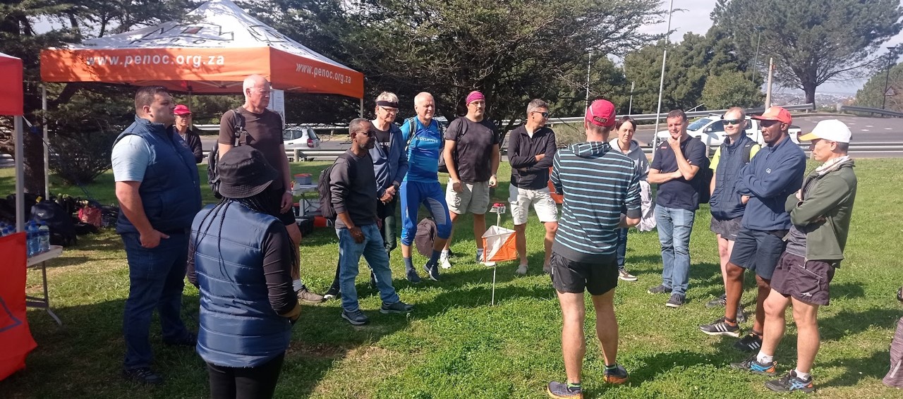
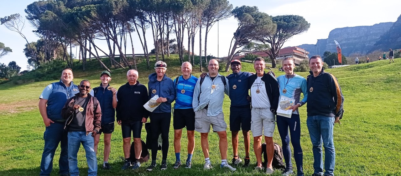
Orienteering event
The ICC2023 orienteering event took place on August 12, 2034 at the University of Cape Town.
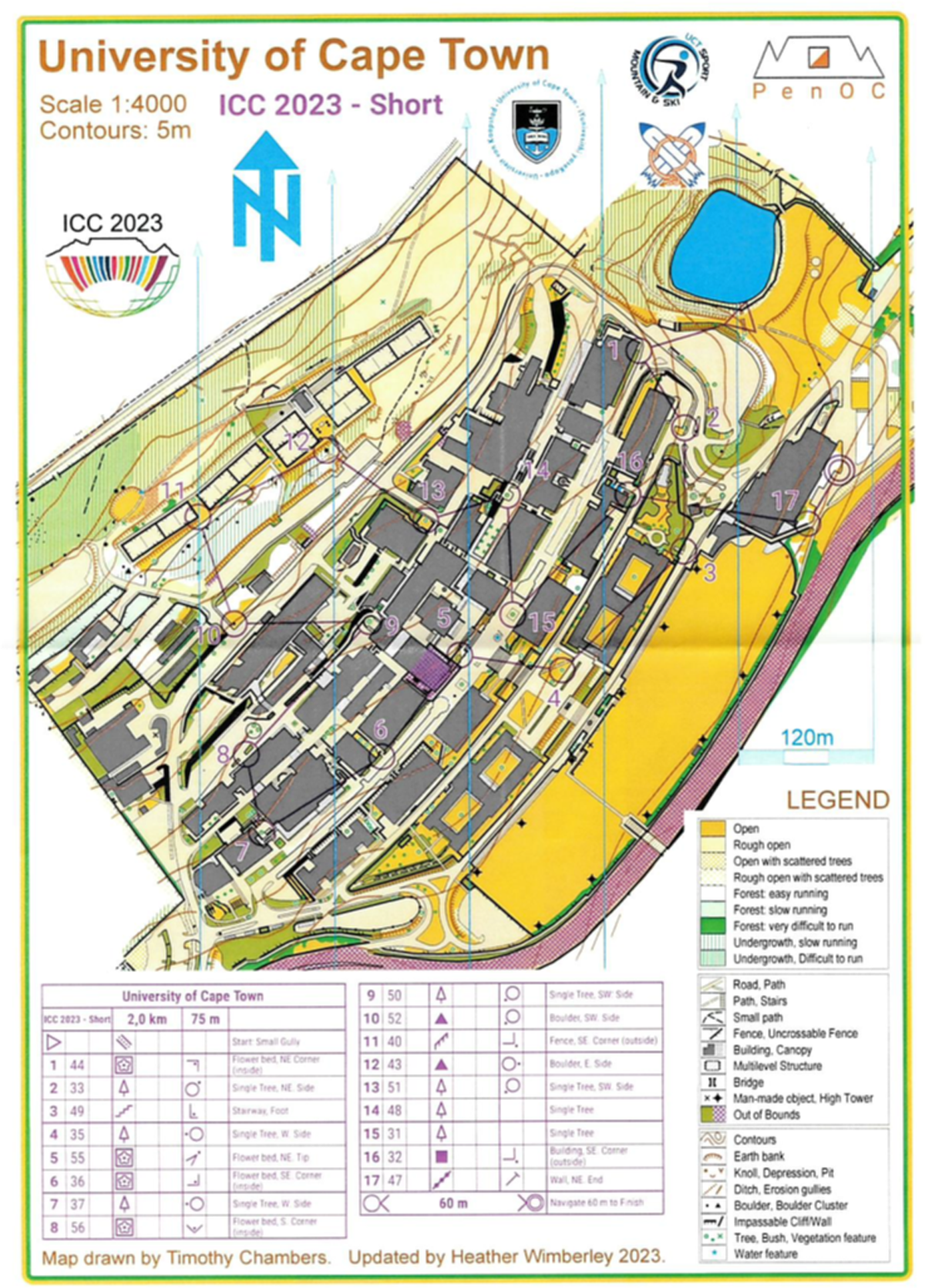
Map of the long course
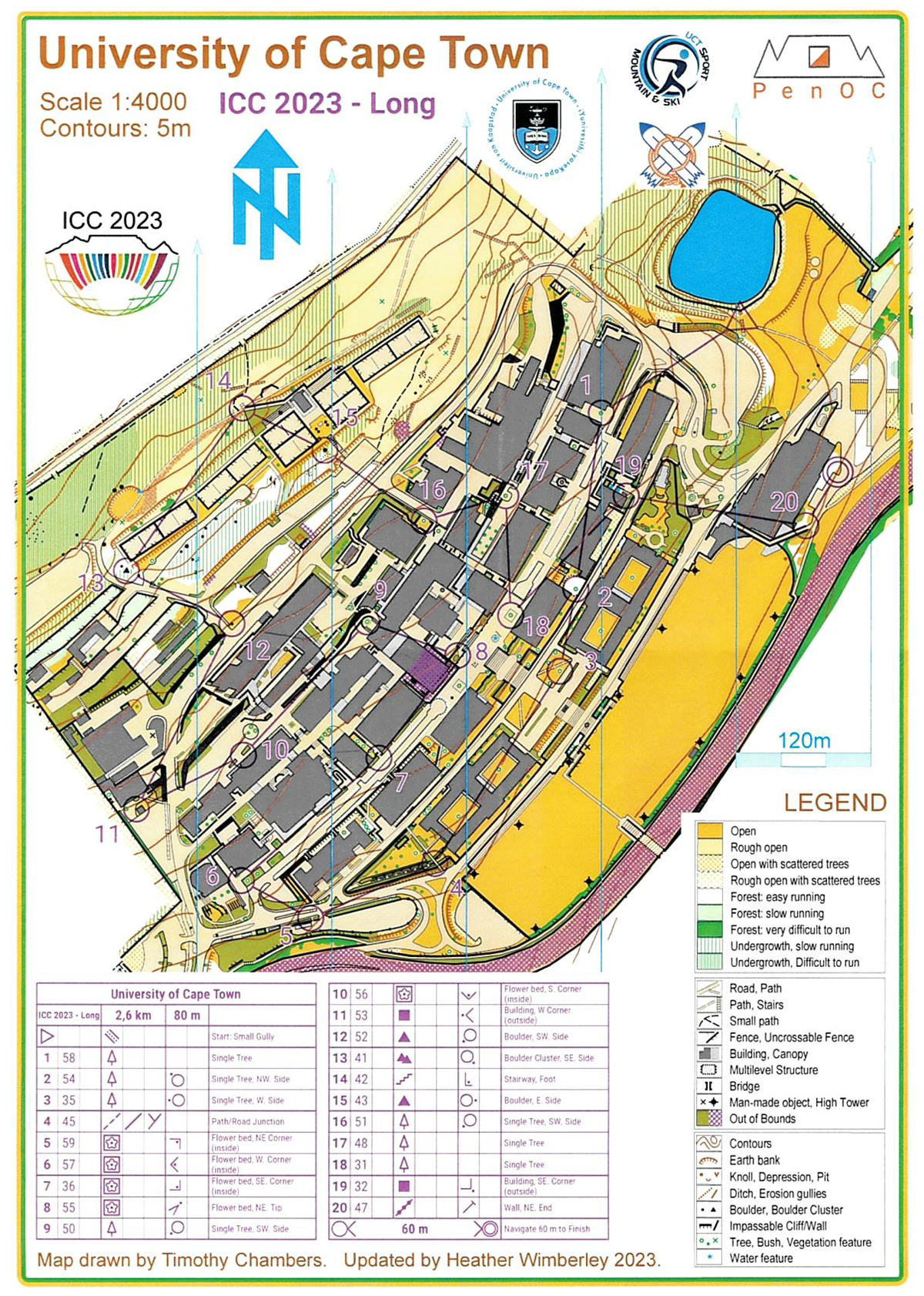
Map of the long course
Long course – 2.6 km, 80 m elevation, 20 control points
| Name | Country | Time | |
| 1 | Dušan Petrovič | Slovenia | 19:53 |
| 2 | Pyry Kettunen | Finland | 20:55 |
| 3 | Terje Midtbø | Norway | 27:21 |
Short course – 2.0 km, 75 m elevation, 17 control points
| Name | Country | Time | |
| 1 | Menno-Jan Kraak | Netherlands | 25:36 |
| 2 | László Zentai | Hungary | 25:56 |
| 3 | Dmitrii Loginov | Russia | 26:09 |
