


At the 27th International Cartography Conference in Rio de Janeiro, Brazil, the cartographic product “Project Supra – Real-time heatmaps from sports workouts” won the first jury prize in the category digital products. The jury stated:
An intuitive, digital multiscale map that presents detailed information in a legible and accessible fashion. Interaction is key and design is stylish.


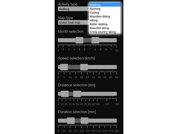


Publisher’s Description: The service demonstrates how privacy preserving heatmaps can be created and visualized on-the-fly based on big data from the Sports Tracker mobile application. The demonstration service processes ca. 1 million workout trajectories. Novelty of the service is in the possibility to filter the contents of the heatmap in real-time. For example, heatmaps can be derived based on cyclists having average speed of >20 km/h and length of the workout >30 km opening new possibilities for creating context-sensitive location-based services. The demo service is one deliverable of the research project Supra funded by the Finnish Funding Agency for Innovation Tekes.
- Platform: web browser
- Authors: Jani Sainio (Åbo Akademi University), Jan Westerholm (Åbo Akademi University) and Juha Oksanen (Finnish Geospatial Research Institute in the National Land Survey of Finland)
- Publisher: Åbo Akademi University and Finnish Geospatial Research Institute in the National Land Survey of Finland
- Date published: 12/2014
- Language: English
