Welcome to the International Cartographic Association
Welcome to the website of the International Cartographic AssociationGet to know the new ICA Executive Committee for the term 2023-2027
Welcome to the website of the International Cartographic Association
Get to know the new ICA Executive Committee for the term 2023-2027

Congratulations to the ICA scholarship awardees at ICC2019 and pre-conference workshops

The goal of ICA Scholarships is to stimulate young scientists or professionals to direct their careers toward fundamental studies in the fields of Cartography and GISciences. The following scholarships were awarded for participation in the ICC2019 and pre-conference workshops.

Scholars at ICC2019

ScholarTitle of paper / poster
Nargiz Safaraliyeva, AzerbaijanTeaching basic map concepts in three countries: Azerbaijan, Hungary and United Arab Emirates
Malak Alasli, MoroccoToponyms’ contribution to identity: The case study of Rabat (Morocco) | Static Risk Mapping of Forest Fires – In the case of the Province of Chefchaouen (Morocco)
Shyamantha SUBASINGHE, Sri LankaUrban Growth: From pixel to reality
Dr. Alena Vondráková, Czech RepublicTouchIt3D: Technology (not only) for Tactile Maps | The Specifics of Cartographic Semiology in Tactile Maps
Ashna Kareem Zada, IraqTesting Maps for Visually Impaired People in Kurdistan
Jagadish B, IndiaDeriving Multiple Representation Database: A Model Generalisation Approach
Lukasz Halik, PolandTeaching of geographical space relations for cartography – Academic Outdoor Station in Poznan (Poland) | Workflow for 3D geovisualization of the data obtained with the use of Unmanned Aerial Vehicle in Augmented Reality | The visualization of the use of land on the basis of the dynamics of the pedestrian movement from the interval UAV imaging | Measuring user preferences in virtual reality (VR): 2D versus 3D urban geovisualizations of topographic data
Márton Pál, HungaryDigital cartography for geoheritage: turning an analogue geotourist map into digital | Possibilities of high precision GPS data in autonomous driving
Nikola Yonov, BulgariaSchool Atlas with Augmented Reality
Radek Barvir, Czech RepublicThe Specifics of Cartographic Semiology in Tactile Maps | TouchIt3D: Technology (not only) for Tactile Maps
Pongpichaya William Limpisathian, USA/ThailandRepresentations of Place in the Human Brain
Ivan Evgenyevich Fokin, RussiaThe automation of processes of atlas mapping | Methods and algorithms for creation of structural schemes of rivers
Nick Lally, USAMapping dynamic, non-Euclidean spaces | Interactive & Multiscale Thematic Maps: A Preliminary Study
Xiao Huang, USA/ChinaLinking picture with text: tagging flood relevant tweets for rapid flood inundation mapping
Carolyn S. Fish, USAEmotional responses to climate change map framing using facial emotion recognition technology
Harrison Cole, USAToward Accessible Hazard Mapping: Tactile Risk Maps and Disaster Preparedness
Laure De Cock, BelgiumLinking perception to decision point complexity for adaptive indoor wayfinding support
Maja Kalinic, Germany/Bosnia-HerzegovinaFloating Car Data and Fuzzy Logic for classifying congestion indexes in the city of Shanghai
Ross Thorn, USAHow to Play with Maps

Scholars at pre-conference workshops

ScholarWorkshopTitle of paper / poster
Aytaç YÜRÜKÇÜ, TurkeyHistory of Cartography and the Topographic MappingHow East and West Cartographic Studies Influenced the Most Important 16th Century Ottoman Cartographer of Piri Reis and His World Maps
Dr. Lei ZOU, USALocBigData 2019Leveraging Location-Based Social Media for Smart Emergency Management
Christian RÖGER, GermanyLocBigData 2019Visualizing the Complexity of Crossings using Star-Plot Maps
Wangshu WANG, AustriaJoint Pre-Conference Workshop of the ICA Commission on Use, Users, and Usability, the Commission on Cognitive Visualization, the Commission on Location-based Services and the Commission on Visual AnalyticsTowards a Functional Ontology for Mobile Map Applications

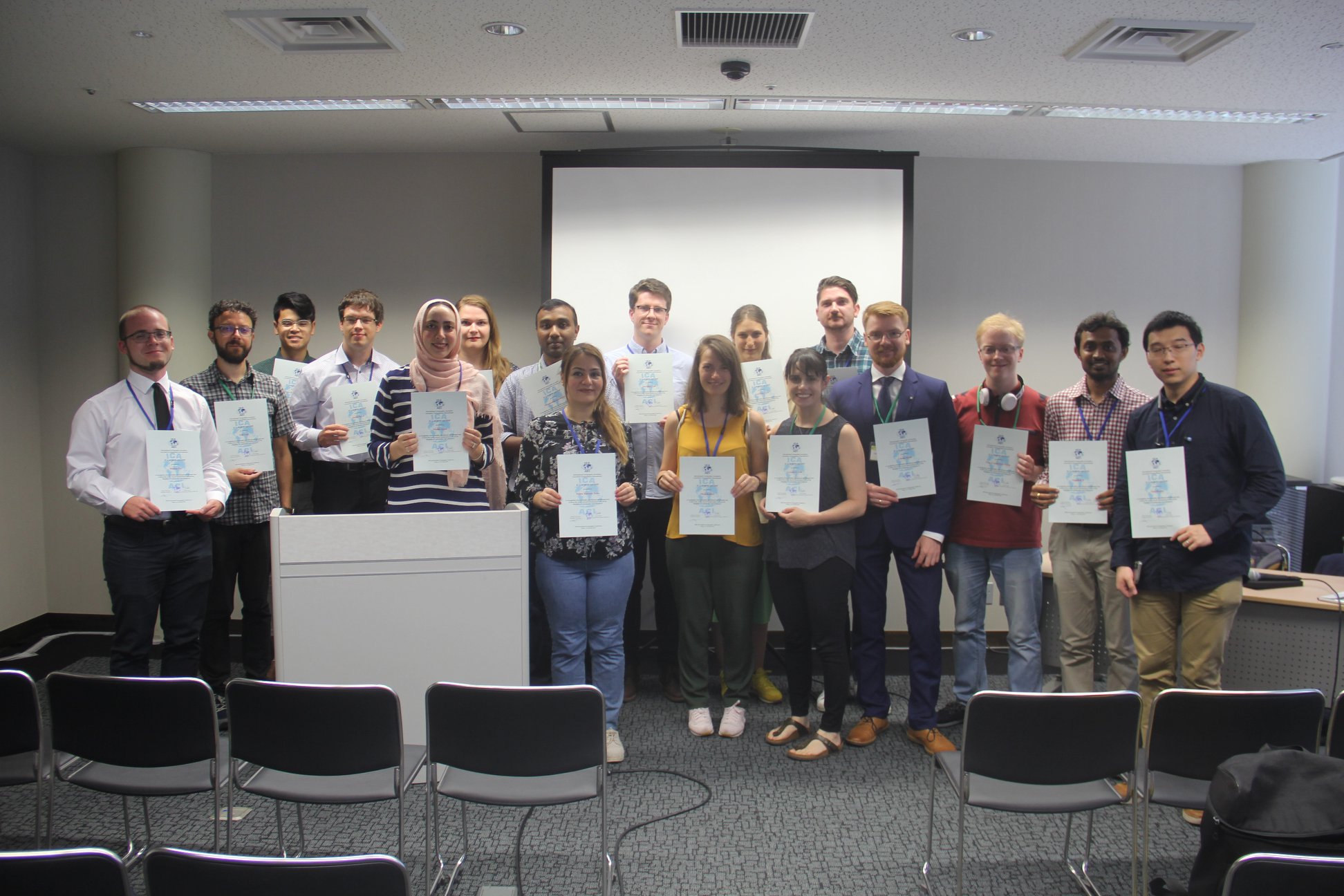
From left to right: Márton Pál, Nick Lally, Pongpichaya William Limpisathian, Radek Barvir, Malak Alasli, Dr. Alena Vondráková, Shyamantha Subasinghe, Ashna Kareem Zada, Harrison Cole, Maja Kalinic, Laure De Cock, Carolyn S. Fish, Nikola Yonov, Lukasz Halik, Ivan Evgenyevich Fokin, Jagadish B, Xiao Huang

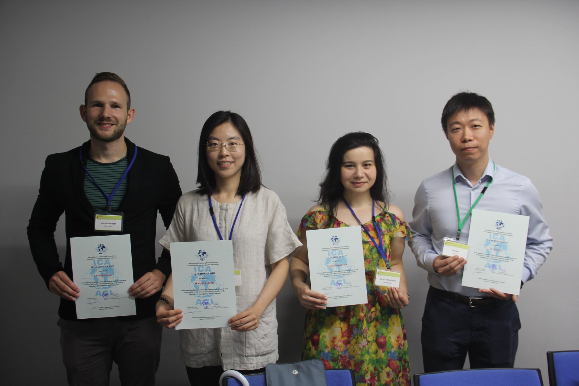
From left to right: Christian Röger (pre-conference), Wangshu Wang (pre-conference), Nargiz Safaraliyeva (ICC), Dr. Lei ZOU (pre-conference)

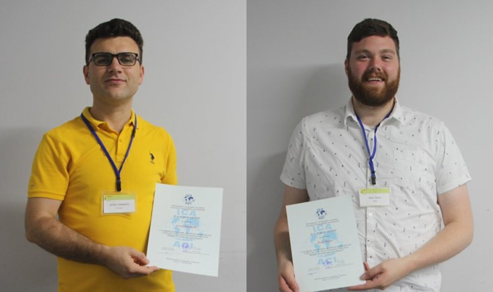
Left: Aytaç YÜRÜKÇÜ, Pre-conference; Right: Ross Thorn, ICC


Congratulations to all scholars!

Recipients of the ICA Map Awards 2019

At the biennial International Cartographic Conferences, ICA organizes an International Map Exhibition, where map products originating from ICA member countries are exhibited. An international jury selects the best entries in six categories; in addition, there is also a public vote. Please find the winners of the ICA Map Awards 2019 below.

Atlases

3rd place: Atlas of Poland’s Political Geography (Poland)

3rd: Atlas of Poland's Political Geography (Poland)

2nd place: Graphical Statistical Atlas of Switzerland 1897–20 (Switzerland)

2nd place: Graphical Statistical Atlas of Switzerland 1897-20

1st place: National Atlas of Hungary (Hungary)

A comprehensive, and detailed atlas. The cartography is lavish and sets Hungary’s natural environment in its human context. The maps are accompanied by numerous well presented graphs, text and infographics.

1st place: National Atlas of Hungary (Hungary)

Digital products

3rd place: Water Rhyme in Gusu (China)

2nd place: Caydence (United Kingdom)

2nd place: Caydence (United Kingdom)

1st place: Politics of Remembrance 1945–2015 (Austria)

A rich map-based portal to explore the memorial landscape of Vienna. The maps are beautifully designed and positioned within a very well constructed application to give the user multiple ways to interact.

Educational cartographic products

3rd place: Statistical Maps: Data Elaboration and Presentation (Poland)

3rd place: Statistical Maps: Data Elaboration and Presentation (Poland)

2nd place: TouchIt3D Tactile Maps (Czech Republic)

2nd place: TouchIt3D Tactile Maps (Czech Republic)

1st place: Cartography. (USA-Esri)

A bit big to take on a plane.

1st place: Cartography. (USA-Esri)

Other cartographic products

3rd place: 3D model of Domnica Cave (Czech Republic)

3rd place: 3D model of Domnica Cave (Czech Republic)

2nd place: Transparent globes (China)

2nd place: Transparent globes (China)

1st place: Map Data Provision Products (Japan)

Incorporating maps into the design of various products is not new but when done well, creates interesting and attractive items. Cartographers will certainly be keen to be seen in these shoes!

1st place: Map Data Provision Products (Japan)

Charts on panels

3rd place: Abords et port de I’île Saint-Pierre (France)

3rd place: Abords et port de I'île Saint-Pierre (France)

2nd place: Tokyo Wan (Japan)

2nd place: Tokyo Wan (Japan)

1st place: The map of Northern Sea Area (China)

Highly colourful and visually stunning, this 3D depiction uses novel technology to provide a rich, immersive experience. Symbols are clear and the depth cues work well at different viewing angles.

1st place: ZThe map of Northern Sea Area (China)

Maps on panels

3rd place: The Melbourne Map (Australia)

3rd place: The Melbourne Map (Australia)

2nd place: Ecological Area Map of the Estuary Wetland of Dagu River (China)

2nd place: Ecological Area Map of the Estuary Wetland of Dagu River (China)

1st place: Fimbulheimen in Dronning Maud Land, Antarctica (Norway)

A huge map portraying a 600km Antarctic mountain range. The size of the map juxtaposes the sparse, barren, yet stunning landscape that skilfully combines satellite imagery with exquisite typography. Beautiful cartography.

1st place: Fimbulheimen in Dronning Maud Land, Antarctica (Norway)

Public Vote: Water Rhyme in Gusu (China)


Congratulations to all winners!


The international jury this year at ICC2019 was co-chaired by Kenneth Field and Ian Muehlenhaus. Further jury members were:

  • Kenneth Field and Ian Muehlenhaus
  • Temenoujka Bandrova
  • William Cartwright
  • Serena Coetzee
  • Igor Drecki
  • David Fairbairn
  • Georg Gartner
  • Amy Griffin
  • Anja Hopfstock
  • Lorenz Hurni
  • Antoni Moore
  • Dušan Petrovic
  • Hiroshi Une
  • Nonoko Tsukada


For a full list of map products exhibited during ICC2019, please check the PDF catalogue.

ICA Awards Ceremony at ICC2019

In the ICA Awards Ceremony at ICC2019, the following awards were presented in recognition of contributions to the ICA.

Evangelos Livieratos, Miljenko Lapaine, Takashi Morita

From left to right: Evangelos Livieratos, Miljenko Lapaine, Takashi Morita

ICA Honorary Fellowship

The ICA Honorary Fellowship is for cartographers of international reputation who have made special contribution to the ICA. It includes a bronze medal.

  • Evangelos Livieratos, Greece
    • Active participant and discussant in several ICA activities, such as ICCs
    • Chair of the WG Digital Technologies in Cartographic Heritage (2005–2007)
    • Chair of the ICA Commission on Digital Technologies in Cartographic Heritage (2007–2015) and ICA Commission on Cartographic Heritage into the Digital (2015–2019)
    • Founder of e-Perimetron
    • Active supporter of the International Map Year
    • Greek National Delegate to ICA
  • Miljenko Lapaine, Croatia
    • Participation in all International Cartographic Conferences since 1989
    • Chair of the ICA Map Projections Commission (2011–2019)
    • Vice-Chair of the ICA Map Projections Commission (2019–2023)
    • Led the development and editing of the 2017 book Choosing a Map Projection for the ICA
    • Active supporter of the International Map Year
    • Croatian National Delegate to ICA

Diplomas for outstanding services to ICA

The Diplomas for outstanding services to ICA are for colleagues who have made special contribution to the ICA as commission officers or conference organizers.

  • Takashi Morita, Japan
    • Member of the ICA Commission on Theoretical Cartography
    • Vice-President of ICA (1999–2003)
    • Chair of the ICA Commission on Ubiquitous Mapping (2003–2011)
    • Chair of Local Organizing Committee for ICC2019
    • President of Japan Cartographers Association (JCA)
    • Chair of the National Committee for Cartography, Science Council of Japan


Congratulations to all awardees!

Winners of the Barbara Petchenik Competition 2019

The Barbara Petchenik Competition is a biennial map drawing competition for children. The competition is first organized on a national level. The national winners can then compete in the international round, which takes place during the International Cartographic Conferences. This year at ICC2019, 188 drawings from 33 countries were exhibited. An international jury selected 12 winners in 4 categories. There was also a public vote, a creativity award and a special mention. Please find the wonderful results below.

Winners <6 years

The Queen of the World by Bianca Belović (5)

1st: The Queen of the World by Bianca Belović (5)

A Boat Symbolizing Peace by Ye Shangke (5)

2nd: A Boat Symbolizing Peace by Ye Shangke (5)

Map is the Most Beautiful Flower in the World by Tara D. J. Suprapto (5)

3rd: Map is the Most Beautiful Flower in the World by Tara Dibbaratana Jayamanggala Suprapto (5)


Winners 6–8 years

Between the Clouds by Liepa Jokubaitytė (7)

1st: Between the Clouds by Liepa Jokubaitytė (7)

Treasure Map of My Dog by Micah Allen Setianto Moore (8)

2nd: Treasure Map of My Dog by Micah Allen Setianto Moore (8)

My Imagination by Luca Kunos (7)

3rd: My Imagination by Luca Kunos (7)


Winners 9–12 years

Dreaming of the Blue Self of the World by Kim Min-Chan (12)

1st: Dreaming of the Blue Self of the World by Kim Min-Chan (12)

A Turtle's Tear: Our Plastic Oceans by Barnaby Blampied (9)

2nd: A Turtle’s Tear: Our Plastic Oceans by Barnaby Blampied (9)

World of Colour Lines by Hande Körbalta (9)

3rd: World of Colour Lines by Hande Körbalta (9)


Winners 13–15 years

Creating Worlds by Rada Skumova (15)

1st: Creating Worlds by Rada Skumova (15)

We Love Maps by Agata Filipiak (14)

2nd: We Love Maps by Agata Filipiak (14)

Hemispherical Understanding by Katarína Šáleková (15)

3rd: Hemispherical Understanding by Katarína Šáleková (15)


Creativity Award

It Is All in Our Hands by Ugnė Rimkutė (15)

Creativity Award: It Is All in Our Hands by Ugnė Rimkutė (15)


Special Mention

The Map Shows Me the Way by Robert Hopjan (11)

Special Mention: The Map Shows Me the Way by Robert Hopjan (11)


Winner of the public vote

Good Morning World by Noemí Sánchez (14)

Public vote: Good Morning World by Noemí Sánchez (14)

Jury

Members of the Jury

Members of the Jury

The jury members were

  • Pilar Sánchez-Ortiz Rodríguez, Spain – Chair
  • Ana María Garra, Argentina
  • Temenoujka Bandrova, Bulgaria
  • Simon Catling, Great Britain
  • Koji Ohnishi, Japan
  • Dariusz Dukaczewski, Poland
  • Necla Ulugtekin, Turkey
  • Naeema Al Hosani, United Arab Emirates
  • Carla Sena, Brazil and Jesus Reyes, Hungary – Substitute Members
  • Peter van der Krogt, The Netherlands – International Coordinator


Congratulations to all winners! Also a huge thank you to all participating children, their parents, teachers and national organizers.

Obituary: Godfried Theodore Toussaint

Portrait Godfried Theodore Toussaint (CC BY-SA 3.0 via Wikimedia)

Godfried Theodore Toussaint

It is with great sadness that we share the news that Godfried Theodore Toussaint passed away while sharing his work at the International Cartographic Conference 2019 in Tokyo. He attended ICC2019 to present his work on “The Levenshtein distance as a measure of mirror symmetry and homogeneity for binary digital patterns” in a special session titled “Design & Computation in Geovisualization” convened by the Commission on Visual Analytics.

Godfried Theodore Patrick Toussaint (1944–2019) was a Canadian Computer Scientist, a Professor of Computer Science, and the Head of the Computer Science Program at New York University Abu Dhabi (NYUAD) in Abu Dhabi, United Arab Emirates. He was considered to be the father of computational geometry in Canada. He did research on various aspects of computational geometry, discrete geometry, and their applications: pattern recognition (k-nearest neighbor algorithm, cluster analysis), motion planning, visualization (computer graphics), knot theory (stuck unknot problem), linkage (mechanical) reconfiguration, the art gallery problem, polygon triangulation, the largest empty circle problem, unimodality (unimodal function), and others. Other interests include meander (art), compass and straightedge constructions, instance-based learning, music information retrieval, and computational music theory.


Results of the 18th General Assembly of the ICA

The 18th ICA General Assembly was closed on the last day of ICC2019.
Slides of the agenda can be found here.

EC at ICC2019

The new Executive Committee for the term 2019–2023 on stage at the closing ceremony of ICC2019


The Executive Committee for the term 2019–2023 is:

  • President: Tim Trainor (USA)
  • Secretary-General and Treasurer: Thomas Schulz (Switzerland)
  • Vice-Presidents:
    • Andrés Arístegui (Spain)
    • Temenoujka Bandrova (Bulgaria)
    • Philippe De Maeyer (Belgium)
    • Liqiu Meng (Germany)
    • Terje Midtbø (Norway)
    • Vít Voženílek (Czech Republic)
    • László Zentai (Hungary)
  • Past President: Menno-Jan Kraak (The Netherlands)

The 19th General Assembly and the 31st International Cartographic Conference in 2023 will be held in Cape Town, South Africa.

Honorary auditors: Harold Moellering (USA) and Bengt Rystedt (Sweden).

Category: General News

Welcome to ICC2019 in Tokyo #icc2019tokyo

The 29th International Cartographic Conference opened in Tokyo, Japan! After busy days with 13 pre-conference workshops, the main conference opened on Monday evening. Papers, proceedings and abstracts are available on the ICC2019 website:

The conference also hosts the International Cartographic Exhibition (click here to download the exhibition catalogue [22mb]), the Children’s Map Exhibition and a Technical Commercial Exhibition.

Also, the 18th General Assembly of the ICA takes place in connection with ICC2019. The first day (discussion) was on Monday; the second day including voting and elections will take place on Friday. The results will be published on the ICA website soon.

To share your experiences and to stay up-to-date with everything happening at the conference, please use hashtag #icc2019tokyo.

Enjoy the conference!

Category: General News
Tag: ,

ICC2019: Paper and Abstract Submission Deadline Extended!

We are pleased to inform you that in response to the overwhelming demand the deadline for the 29th International Cartographic Conference (ICC2019) for full paper submission was extended to December 12, 2018. The deadline for abstract submission was also extended to January 8, 2019. International Cartographic Association (ICA) encourages submissions from all interested participants from across the globe.

Visit the ICC2019 website for the details.

ICC2019 Local Organizing Committee
If you have any enquiries, please contact: icc2019@issjp.com

Category: General News
Tag: , ,

Information about the 2019 ICC and General Assembly

We invite you to the 29th International Cartographic Conference (ICC) and to the 18th General Assembly of the International Cartographic Association. The conference will be held in Tokyo, Japan, from 15 to 20 July 2019, and all those active in cartography and geographic information sciences in your country are warmly invited to participate. In addition, the 18th General Assembly of the ICA will take place at the same venue.

We are looking forward to celebrating this unique event of Mapping Everything for Everyone, something which is most relevant, attractive, and modern to our societies and economies. We encourage as many cartographers and GI scientists as possible from your country to be present in Tokyo to participate in this wonderful occasion.

Information and deadlines for national members concerning paper submission, the International Cartographic Exhibition, the Barbara Petchenik Children’s World Map Competition, ICA Scholarships and the General Assembly can be found in the following document:

László Zentai
Secretary-General and Treasurer of the ICA

Category: General News

ICC2019: Call for abstracts and papers is now open!

icc2019-logo

The 29th International Cartographic Conference will take place in Tokyo, Japan, 15–20 July 2019. The Organizing Committee of ICC2019 invites all interested participants to submit full papers or abstracts for the oral or poster presentations.

All submissions will be reviewed by the International Scientific Committee. All accepted submissions will be published as the Advances in Cartography and GIScience of the ICA, Proceedings of the ICA, or Abstracts of the ICA. Selected papers will also be published in the International Journal of Cartography.

All details and the submission form can be found on the ICC website: icc2019.org/papers.html.

Important Dates

Papers

  • Submission of full manuscript for Advances: 5 December 2018
  • Submission of abstracts for Abstracts and Proceedings: 19 December 2018
  • Notification of acceptance: 20 February 2019
  • Submission of final manuscripts for Proceedings and Advances: 3 April 2019

Exhibition

  • Submission interface for International Cartographic Exhibition opens: 12 December 2018
  • Submission interface for International Cartographic Exhibition closes: 6 March 2019

Registration

  • Conference registration deadline for presenters/authors: 3 April 2019
  • Deadline for Early-Bird-Fees: 3 April 2019

Conference Topics and Paper Themes

  • T01 Art and Cartography
  • T02 Atlases
  • T03 Cartographic Heritage into the Digital
  • T04 Cartography and Children
  • T05 Cartography in Early Warning and Crisis Management
  • T06 Cognitive Issues in Geographic Information Visualization
  • T07 Education and Training
  • T08 Generalisation and Multiple Representation
  • T09 Geospatial Analysis and Modeling
  • T10 GI for Sustainability
  • T11 History of Cartography
  • T12 Location Based Services
  • T13 Map Design
  • T14 Map Production and Geoinformation Management
  • T15 Map Projections
  • T16 Maps and Graphics for Blind and Partially Sighted People
  • T17 Maps and the Internet
  • T18 Mountain Cartography
  • T19 Open Source Geospatial Technologies
  • T20 Planetary Cartography
  • T21 SDI and Standards
  • T22 Sensor-driven Mapping
  • T23 Topographic Mapping
  • T24 Toponymy
  • T25 Ubiquitous Mapping, Spatial DB and IoT-Based Systems
  • T26 Use, User and Usability Issues
  • T27 Visual Analytics
  • T28 Marine Cartography
  • T29 Digital Humanities and GIS
  • T30 GIS, Remote Sensing and Cartographic Theory, Methodology and Applications
  • T31 Visualization and Analysis of Geographical Process
  • T32 Mapping Cities
  • T33 Design and visual variables: Rethinking Jacques Bertin
  • T34 Geo for All: Open source GIS education
  • T35 Crowdsourced Geospatial Information
  • T36 Transition to Modern and Contemporary Mappings
  • T37 Maps for SDGs
  • T38 Mapping the Environment
  • T39 Theoretical Cartography
  • T40 AI, Robotics, Autonomous Cars and Mapping
  • T41 Maps and Games
  • T42 Big Data and Data Science
  • T43 Others

For more details, please visit the conference website.

Category: General News
Tag: , ,
rawboned-refined