Welcome to the International Cartographic Association
Welcome to the website of the International Cartographic AssociationGet to know the new ICA Executive Committee for the term 2023-2027
Welcome to the website of the International Cartographic Association
Get to know the new ICA Executive Committee for the term 2023-2027

Call for Participation for the Pre-ICC Workshop Reclaiming Through Mapping: The Olympic Sites of Tokyo

The ICA Commission on Art & Cartography invites you to participate in their Pre-Conference Workshop “Reclaiming through Mapping: Olympic Sites of Tokyo.” Some of these spaces, including the main conference venue, are on reclaimed land or artificial islands in Tokyo Bay built out of waste landfill. This workshop investigates the question of how place is constructed and mapped, using an experimental methodology developed by the artist-research collective Hamilton Perambulatory Unit, who will lead a participatory mapping walk in Tokyo that looks to uncover the layers of urban development history of the 2 Tokyo Olympics and the high-growth (1964) and post-growth (2020) periods they represent. This interdisciplinary workshop uses hybrid spatial and sensory ethnography and intermedial approaches to map a site and distinguish the layers of time, history, materiality, and digital city-image. Participants will be asked to contribute to the final multi-media strata-map of Tokyo’s Olympic sites.

To begin this two-day workshop, we will meet at the Tokyo Metropolitan University for short presentations to contextualize our experimental and sensory mapping methodologies, before continuing the discussion on the trains while heading towards the Toyosu fish market for lunch (45min from Akihabara). We will then visit the nearby construction site of the Athlete’s Village on Harumi Island while we give some background on the area, and spend some time mapping the site. On the second day, we will meet at one of the 1964 Olympic sites to further explore mapping methodologies before heading back to Tokyo Metropolitan University to share results. The data collected will help answer the following research questions: How does the official Olympic narrative affect the sites? How do experimental cartographies work to investigate how place is constructed?

Registration

The workshop is open to everyone with an interest in sensory mapping art practices and experimental cartographies. Registration is required and is free of charge. Please note that it is not necessary to be registered for the main ICC conference (which requires fees) to be able to attend the workshop.

For more information or to register, please contact Taien Ng-Chan taien [at] yorku.ca or Sharon Hayashi hayashi [at] yorku.ca. Please include a short bio and indicate your interest in the workshop.

Invitation to Pre-ICC Workshop on Spatial Data Infrastructures, Standards, Open Source and Open Data for Geospatial (SDI-Open 2019)

SDI-Open 2019, the pre-conference workshop on spatial data infrastructures, standards, open source and open data for geospatial will be held on 15 July 2019 in Tokyo, Japan, immediately before the 29th International Cartographic Conference. The workshop is jointly organized by the Commission on SDI and Standards, the Commission on Open Source Geospatial Technologies and the Commission on Map Production & Geoinformation Management.

Mr Reese Plews from Japan, who chairs the ISO/TC 211 Terminology Maintenance Group, will make a special contribution with a presentation about the standardization and harmonization of geospatial information terminology in ISO standards, including the maintenance of a multi-lingual register of terms.

Other presentations on the program cover topics, such as international geospatial information standards and interoperability, UN-GGIM Europe and GeoSTAT requirements for spatial data integration, academic SDIs and open science, open source components for service-oriented mapping, and supply chains.

The day is concluded with an interactive and collaborative mapping session in OpenStreetMap. Delegates should bring their own laptops! Details, including a link for registration, are available on the website of the Commission on SDI & Standards at http://sdistandards.icaci.org/

The detailed program can be found on https://sdistandards.icaci.org/program-sdi-open-2019/.

Announcement of the Pre-ICC Workshop on Disaster Risk Reduction (DRR) Challenges for Cartography in Big Data Era

The Commission on Cartography for Early Warning and Crises Management (CEW&CM) is organizing a pre-conference activitiy of ICC2019 in Tokyo and Tsukuba on July 13–14, 2019.

Structure & Topics

Saturday, July 13, 10:00–18:00, Tokyo, Kokusai Kogyo co., Ltd., Conference Hall

  1. Research Agenda of Cartography for DRR
  2. Public and private partnership in the field of cartography to realize DRR

Subtopics:

  • 2D&3D dynamic visualization for disaster process display
  • Interactive visualization method based on the disaster mechanism model
  • Spatial cognition and map design for indoor emergency mapping

Sunday, July 14, 11:00–17:00, Tsukuba, GSI, Museum Conference Hall

  1. Innovation of geospatial information technology to cope with disaster
  2. International cooperation in cartography for DRR
  3. New trends in Cartography for DRR

Subtopics:

  • Maps for decision support system
  • Smart cartography
  • Adaptive cartography
  • UX-design
  • Virtual Geographic Environment

Participants are also invited to propose topics connected with activities of our commission as well as topics of the Tokyo and Tsukuba workshop.

Organization of the event

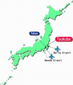
On Saturday July 13 the workshop in Tokyo will be held with the kind help of one of the leading surveying and mapping companies Kokusai Kogyo Ltd. which will provide their conference room and personally endorsed our event by its Chairperson and CEO Ms. Sandra WU. Keynote presentation on behalf of the company will be focused on the role of the private sector for tackling disasters.

On Sunday July 14th Workshop will be held in the Museum building of the Geospatial Information Authority (GSI) of Japan, endorsed by Mr. Shigenobu KAWASAKI, GSI Director General. The keynote will be oriented for the role of GSI in disaster solving activities.

Instructions about transport to both places is available on the workshop website

Abstracts

Information about abstracts formats are available on the workshop website. All abstracts will be blind-reviewed and the best of them will be recommended as papers for high quality journals.

Contacts

Announcement of the Pre-ICC Workshop Cartography for Specific Users

The Commissions on Cartography and Children, Maps and Graphics for Blind and Partially Sighted People and Planetary Cartography have the pleasure to invite all interested colleagues to participate in our Joint ICA Workshop on Cartography for Specific Users, to be held in Tokyo, Japan on July 15, 2019.

General Information

The National Museum of Emerging Science and Innovation (Miraikan) is the venue of the Joint ICA Worshop on Cartography for specific users.

Participation in the event is free, but registration is needed. The registration can be made on the event website.

Deadlines

  • Deadline for the submission of papers and abstracts with registration form: April 22, 2019
  • Notification of the authors: May 6, 2019
  • Deadline for the submission of the registration form (without full paper, only participant): June 10, 2019

Organizing Committee

  • Carla Cristina R. G. de Sena, Chair, ICA Commission on Cartography and Children (Brazil)
  • José Jesús Reyes Nunez, Vice-Chair, ICA Commission on Cartography and Children (Hungary)
  • Alejandra Coll Escanilla, Chair, ICA Commission on Maps and Graphics for Blind and Partially Sighted People (Chile)
  • Waldirene Ribeiro, Vice-Chair, ICA Commission on Maps and Graphics for Blind and Partially Sighted People (Brazil)
  • Henrik Hargitai, Chair, ICA Commission on Planetary Cartography (Hungary)
  • Irina Petrovna Karachevtseva, Vice-Chair, ICA Commission on Planetary Cartography (Russia)


Please find more information on the workshop website: icaworkshop2019.elte.hu. Do not hesitate to contact the organizers if you have any question or need more information.

Announcement of the Pre-ICC Workshop Reclaiming Through Mapping: The Olympic Sites of Tokyo

The ICA Commission on Art & Cartography invites you to participate in their Pre-Conference Workshop “Reclaiming through Mapping: Olympic Sites of Tokyo.” Some of these spaces, including the conference venue, are on reclaimed land or artificial islands in Tokyo Bay built out of waste landfill. This workshop investigates the question of how place is constructed, using an experimental, performative and site-specific methodology developed by the art-research collective Hamilton Perambulatory Unit, who will lead a participatory mapping walk in Tokyo that looks to uncover the layers of urban development history of the 2 Tokyo Olympics and the high-growth (1964) and post-growth (2020) periods they represent.

This will be a two-day workshop. On the first day, organizers will provide a short morning tour to the1964 Olympic Village site which repurposed US occupation military housing from 1946; the afternoon will be spent on presentations from the participants and on experimental mapping methodologies. On the second day, to complete their own maps, participants will visit a 2020 Olympic site near the conference venue, and return in the afternoon to share results. The data collected will help answer the following research questions: Are there traces of this rich history in the material environment? How does the official Olympic narrative affect the sites? How do experimental cartographies work to investigate how place is constructed? This interdisciplinary workshop uses hybrid spatial and sensory ethnography and intermedial approaches to map a site and distinguish the layers of time, history, materiality, and digital city-image. Participants will be asked to contribute to the final multi-media strata-map of Tokyo’s Olympic sites.

Registration

The workshop is open to everyone with an interest in sensory mapping art practices and experimental cartographies. Registration is required and is free of charge. Please note that it is not necessary to be registered for the main ICC conference (which requires fees) to be able to attend the workshop.

You can register for the workshop by email: taien [at] yorku.ca

Please include a short bio and indicate your interest in the workshop.

For more information, please contact Taien Ng-Chan taien [at] yorku.ca or Sharon Hayashi hayashi [at] yorku.ca

Announcement of the Pre-ICC Workshop on Cartography as a Cultural Encounter: How East and West have Mapped and Influenced Each Other

The ICA Commission on the History of Cartography and ICA Commission on Topographic Mapping take pleasure in inviting you to their joint international preconference workshop: Cartography as a Cultural Encounter: How East and West have Mapped and Influenced Each Other. The workshop will be held at the National Museum of Emerging Science and Innovation, on 15 July 2019. The workshop is open to all cartographers, geographers, historians, map collectors, academics and lay persons interested in the diverse aspects of the history of cartography and topographic mapping.

The joint organizers invite papers on both western and eastern cartographic practice from a historical perspective, from the early modern era until the early 20th century. Themes include how each of these cartographic traditions developed over time, how they understood and mapped their own space but also how they mapped and saw Others, and how these diverse cartographic cultures and practices around the globe contributed to the dissemination of geographic knowledge.

Although the Symposium will primarily focus on these themes, submissions of high quality on endeavors in other fields of cartographic history and topographic mapping will also be considered.

Venue

The intended venue is the National Museum of Emerging Science and Innovation, located in the beautiful Tokyo bay area. The Museum is equipped with an excellent space for our conference sessions, map exhibition and technical exhibition. The conference venue is surrounded by more than 3 000 hotel rooms within walking distance.

Call for Papers

The organizers invite the submission of abstracts for oral presentations (25 min + 5 min for questions and discussion). These need to reach the organisers by 30 March 2019. You can submit your abstract here.

Registration

The workshop is open to everyone with an interest in the history of cartography and topographic mapping but requires participants to register. Registration will be open until the available seating is allocated and is free of charge. Please note that it is not necessary to be registered for the main ICC conference to be able to attend the workshop. You can register for the workshop here.

Contact

Questions regarding the workshop can be directed to:

  • Mirela Altic – Vice-Chair ICA Commission on the History of Cartography: mirela.altic(at)gmail.com
  • Alexander Kent – Chair ICA Commission on Topographic Mapping: alexander.kent(at)canterbury.ac.uk


Please find more information on the workshop website: history.icaci.org/tokyo-2019

Announcement of the Pre-ICC Workshop on Abstraction, Scale & Perception

The ICA Commissions on Cognitive Issues in Geographic Information Visualization, and on Generalisation and Multiple Representation, are pleased to organize a joint one-day workshop dedicated to advances, works in progress, and position statements about the perception of geospatial abstractions and scale in maps and geovisualisations.

Abstraction is the main process for moving from a geographic space or phenomenon to its representation as spatial information. Abstractions may be conceptual, geometric, semantic, graphic, visual, or cognitive. Examples include techniques to highlight, enhance, or simplify salient characteristics or properties, in order to support visual communication, recognition, understanding of spatial features and inferring knowledge about spaces. If different aspects of abstraction are not managed well, across different scales, for example when navigating through scales in geoportals, it can lead to perceptual difficulties in reading the map. Generalisation is the process of deliberately transforming existing geospatial data or their symbolisation into more abstract representations, and multiple representation involves creating a series of such generalisations, often distributed through map scale.

The workshop will feature research presentations and open-ended brainstorming sessions, and will focus on identifying open research gaps and the elaboration of a shared research agenda. We encourage submissions from any practitioner of abstraction or generalisation: those in academia, industry, or government, among other sectors, are welcome.

Paper deadline: 22nd February 2019

Topics of interest include but are not limited to:

  • multi-scale, multi-source and multi-view graphic representation
  • massive data (“Big Data”) generalization
  • continuous visualization (across scales) and fluid interaction with graphic representations
  • (semi) automated approaches for map design and geovisualization
  • generalisation, schematization, and stylization techniques
  • visual perception measures and experimental approaches to assess visual perception
  • thematic applications: statistical and socio-economic data, spatio-temporal data and phenomena, urban and environmental dynamics, etc.
  • technical applications, adaptation to visualization devices, (i.e., smartphones, tablets, VR/AR) and use contexts (e.g.,  emergency and crisis management, individual mobility, industrial purposes, etc.).


Please find more information on the workshop website: icc2019abstraction.wordpress.com

Announcement of the Pre-ICC Workshop on Atlases and Infographics

Sunday, 14 July 2019, Tokyo
The final event location at the ICC venue will be announced

Over centuries atlases have been defined as a “book of maps” or “bound collection of maps” with a strong emphasis on the depicting geographic space through the sole use of maps. In 1795, William Playfair published, what was the first statistical atlas. In this Commercial and Political Atlas but he not only used maps, but also area and bar charts, line graphs and histograms.

These statistical information graphics became prominent in the 19th century, spawning iconic examples such as Minard’s map of Napoleon’s march on Moscow or Florence Nightingale’s graphs on the Crimean war.

Their prominent appearance in atlases has put statistical information graphics on the forefront in developing visualization forms for geographical information. The Statistical Atlas of the United States (1870), Otto Neurath’s Modern Man In The Making (1939), Erwin Raisz’ Atlas of Global Geography (1944) and the Atlas of Switzerland (2000) mark keystones on the way infographic became an inevitable constituent of modern atlases.

The one-day workshop consists of two parts. Part one will focus on historical and novel advancements in the use of infographics for atlases in two sessions with short paper contributions (10 minutes presentation + 5 minutes for discussion). Part two focuses on a discussion of recent developments to contribute to new atlas frameworks considering the future use of infographics and the utilization of different graphical techniques.

Contributions

Authors are invited to submit short abstracts (up to 100 words) until 1st March 2019 directly (e-mail) to the organizers.

In case of too many contributions, the organizers will select those who fit best the atlases and infographics’ scope.

Publications

After the workshop, PDFs of the presentations and further findings will be published on the CoA website. A paper publication of selected contributions will be envisaged.

Attendance

If you wish to attend without presenting or want to be updated personally, please register your interest by informing the organizers.

Organizers


Please find more information on the workshop website: atlas.icaci.org/icc-preconference-workshop-atlases-and-infographics

ICC2019: Paper and Abstract Submission Deadline Extended!

We are pleased to inform you that in response to the overwhelming demand the deadline for the 29th International Cartographic Conference (ICC2019) for full paper submission was extended to December 12, 2018. The deadline for abstract submission was also extended to January 8, 2019. International Cartographic Association (ICA) encourages submissions from all interested participants from across the globe.

Visit the ICC2019 website for the details.

ICC2019 Local Organizing Committee
If you have any enquiries, please contact: icc2019@issjp.com

Category: General News
Tag: , ,

Invitation to Pre-ICC Symposium on Location-based Big Data 2019

We are happy to invite you to a pre-ICC2019 symposium on Location-based Big Data 2019 (LocBigData 2019), which will take place in Tokyo, Japan on 15 July 2019. This symposium is co-organized by the ICA Commission on LBS, and Commission on Geospatial Analysis and Modelling.

This symposium aims to offer a common ground for researchers from various fields and perspectives to share ideas and research findings, and to discuss the open challenges and future research direction on location-based big data (e.g., tracking or sensing data, social media data and crowdsourced geographic information).

You are invited to submit work-in-progress or position papers with a length of 600-1200 words by 15 February 2019. All submissions will be peer reviewed. We intend to have a special issue at an international journal after the symposium.

More information can be found at lbs.icaci.org/locbigdata/

We are looking forward to your contributions and to meeting you in Tokyo.
Haosheng Huang, Angela Yao, Jukka Krisp and Bin Jiang

rawboned-refined