Welcome to the International Cartographic Association
Welcome to the website of the International Cartographic AssociationGet to know the new ICA Executive Committee for the term 2023-2027
Welcome to the website of the International Cartographic Association
Get to know the new ICA Executive Committee for the term 2023-2027

Obituary: Igor Drecki – A passionate Cartographer

It is with heavy hearts and profound sadness that we remember our friend and colleague Igor Drecki who, with his wife Iwona, met an untimely end in a car accident on July 26.

Igor was the official New Zealand representative at the general assemblies of the ICA since 1999. He was organizer of numerous ICA events in New Zealand, including the ICA Commission on Visualisation and Virtual Environments Meeting “Geovisualisation on the Web” (Taupo 2001), ICA Internet Cartography Seminar (Auckland 2005), ICA Internet Cartography Workshop (Auckland 2006), and ICA Regional Symposia on Cartography for Australasia and Oceania (Auckland 2010, 2012, 2014 and Wellington, 2016). He was also co-organizer of the 8th ICA Mountain Cartography Workshop (Taurewa 2012). In addition to being an ex-officio member of the ICA Executive Committee (since 2007), he was probably best known to many within and outside the ICA as editor of the ICA News, the official newsletter of the ICA. For his many notable contributions to the ICA, he received the Diploma for Outstanding Services to the ICA in 2017.

In 2017, Igor received the ICA Diploma for Outstanding Services from then-president Menno-Jan Kraak.

His passion for cartography started with his master studies in geography and cartography at the University of Warsaw, and it continued after he settled with his wife Iwona in New Zealand while pursuing a master’s of science degree at the University of Auckland on “Visualization of Uncertainty in Spatial Data”. His research and work experience included professional positions in academia, industry, public administration and most recently libraries and learning services. He was the responsible curator of cartographic and geographic resources of the University of Auckland Library, then latterly curator, Cartographic and Geospatial Collections at the Alexander Turnbull Library, housed within the National Library of New Zealand in Wellington.

Igor was instrumental in the success of the New Zealand Cartographic Society (NZCS). He was a member since 1989 and a life member since 2011; president from 2013 to 2018; NZCS’s (as national member) liaison to the International Cartographic Association (ICA); and director of the biennial New Zealand national cartographic conference, GeoCart, since 2001.

Igor Drecki at GeoCart 2022

Despite his impressive professional record and accomplishments, Igor was “authentic”. He had strong opinions and was ready to stand up for them; he was passionate about cartography and maps; and was a staunch advocate for cartography. But more than this, he was a person who could relate to others. He was interested to learn, discuss, exchange as well as interrelate, give, serve, help, and contribute. This was certainly true for his colleagues and his family, but also for those of us who considered Igor a friend. He was a noble man at heart.

We will miss you, Igor.

Aileen Buckley, Anthony Moore, Dusan Petrovic, Georg Gartner

Obituary: Eddy Lynn Usery

On March 22, 2022, the world lost a GIS giant and cartography compadre when Dr. E. Lynn Usery, current Chair of the ICA Commission on Map Projections and former ICA Vice-President, passed from this earthly plane. Not even a week earlier, Lynn was busily planning workshops for AutoCarto 2022. He will be sorely missed by ICA and our community, not only for his many research contributions, leadership and vision, and tireless service, but also for his friendship and camaraderie.

Michael Tischler of the U.S. Geological Survey (USGS) wrote, “On paper, we knew him as the Director of the Center of Excellence for Geographic Information Science [CEGIS]. But he was far more than that title would lead one to believe. Lynn leaves a remarkable legacy given his extraordinary scientific accomplishments, presence as a leader in the geographic science community, and impact on individual geographic scientists inside USGS and around the world.”

It’s a challenge to specify the impact that Lynn has had on the field of GIScience because of the breadth and depth of his involvement and contributions. He was centrally involved in many areas of the discipline, including cartography, GIS, remote sensing, and spatial analysis. His eclectic research interests included digital cartography, map projections, scale and resolution, image classification, temporal GIS, geospatial semantics and ontology, and high-performance computing for geospatial data. It would be difficult to name a subject in our field about which Lynn could not speak knowledgably and insightfully.

Lynn was unique in that his impact came through his careers in both government and academia. Lynn started working for the USGS in 1977. He was a cartographer and geographer for the USGS from 1978 to 1988 focusing on developing automated cartographic production systems. In 1988, he took on a geography faculty position at the University of Wisconsin (UW) – Madison. In January of 1994, he moved to Georgia to serve on the geography faculty at the University of Georgia (UGA). In May of 1999, Lynn took on a Research Geographer position with the USGS in addition to his academic job at UGA. In 2005, he returned to USGS and ultimately conceived and became Director of CEGIS. In this role, he directed the science program and the visions and plans for topographic mapping research. While at USGS, Lynn also taught remote sensing at the Missouri University of Science and Technology.

In all his positions, Lynn was a ground breaker. In his early days at USGS, he began the development of digital mapping systems for the automated production of printed topographic maps. At UW, he helped found a GIS program. At UGA, he helped establish certificate programs in GIScience at both the undergraduate and graduate levels. When he returned to USGS, he started a cartography research program that led to CEGIS. For CaGIS, he chaired AutoCarto 2005 to close an eight-year gap and resurrect the symposium series. He also spearheaded the effort to bring the International Cartographic Conference back to the United States for only the second time, the first being in 1978.

Lynn was involved in multiple activities of the ICA:

  • 2004–2008 US National Committee to the ICA member
  • 2007–2011 ICA Map Projections Commission Secretary
  • 2007–2015 US National Committee to the ICA Chair
  • 2011–2012 ICA Technology Outreach Working Group Chair
  • 2011–2015 ICA Map Projections Commission Vice Chair
  • 2011 Bid for ICC 2017
  • 2012–2017 ICC 2017 Conference Organizer
  • 2015–2019 ICA Vice President
  • 2018–2019 ICA Body of Knowledge for Cartography Working Group Chair
  • 2019–2022 ICA Map Projections Commission Chair

That Lynn was so involved in the association is admirable. That he did the same with many other societies, at the same time, makes Lynn exceptional and unparalleled. There is truly no match for him in this regard, and really not even anyone in the running. No other person has been elected vice-president of the ICA, president of the Cartography and Geographic Information Society (CaGIS), president of the American Society for Photogrammetry and Remote Sensing (ASPRS), and president of the University Consortium for Geographic Information Science (UCGIS), as Lynn was in 2015, 2002, 2004, and 2015, respectively. Additionally, as with the ICA, in all these associations, he also served in other roles.

On a personal note, Lynn was born in December 1951. He had two children, a son Kelynn, born 1986, and a daughter, Lacy, born 1988. Lynn received his BS in geography from the University of Alabama and MA and Ph.D. degrees in geography from UGA. He died Tuesday, March 22, 2022, after a brief illness.


Tim Trainor, President of ICA &
Aileen Buckley, U.S. national representative to ICA

Obituary: Monique Pelletier

Monique Pelletier (1934-2020)

Monique Pelletier nous a quittés le 21 janvier 2020, à l’âge de 85 ans.

Monique Pelletier est née à Issy-les-Moulineaux le 9 septembre 1934. Archiviste-paléographe, elle a consacré sa thèse de l’École des Chartes au Grand Conseil, de Charles VII à François 1er. Toute sa carrière de conservateur s’est déroulée à la Bibliothèque nationale de France, où elle  a exercé deux postes différents : de 1960 à 1977, elle a assuré la direction de la publication du « nouveau catalogue général » pour les publications arrivées à la BnF entre 1960 et 1970. À ce titre, elle a participé à la définition des normes internationales de description bibliographique. Puis en 1977, elle est nommée directeur du département des Cartes et plans, poste où elle resta 22 ans, jusqu’en 1999.

Monique Pelletier savait aussi encourager les travaux des chercheurs. Elle a accueilli dans le Département plusieurs « pensionnaires » détachés à l’issue de leurs études à l’École normale Supérieure et elle a su leur proposer des travaux intéressants, inscrits dans des problématiques contemporaines. Elle a également toujours été disponible pour aider les amateurs qui se lançaient dans des recherches.

Elle s’est engagée très vite dans les travaux du Comité français de cartographie dont elle fut présidente de 1988 à 1995. Elle a pris la direction de sa revue, Le monde des cartes, en 1992 et cela jusqu’à ces toutes dernières années.

Elle a su s’engager dans les organisations ou les associations professionnelles françaises ou internationales liées à l’histoire de la cartographie et y avoir une place éminente : elle a été membre de la section de géographie du CTHS dès 1977, avant d’en assurer la présidence vingt ans plus tard ; elle a présidé la commission histoire de la cartographie de l’Association cartographique internationale (1987-1995) ; elle a participé également aux travaux du « groupe des cartothécaires » de LIBER, aux travaux d’Imago Mundi, de Cartographica Helvetica, etc.

Ainsi l’activité de Monique Pelletier était à l’image de sa personnalité combattive et généreuse, toujours prête à se lancer dans de nouveaux projets, mais en sachant les mener à bien et à encourager ceux qui souhaitaient se lancer dans la même voie qu’elle. Les témoignages qui accompagnent l’ouvrage Tours et contours de la Terre sont à ce titre très émouvants et montrent la richesse de cette personnalité hors du commun.

Hélène Richard

Category: General News

Obituary: Godfried Theodore Toussaint

Portrait Godfried Theodore Toussaint (CC BY-SA 3.0 via Wikimedia)

Godfried Theodore Toussaint

It is with great sadness that we share the news that Godfried Theodore Toussaint passed away while sharing his work at the International Cartographic Conference 2019 in Tokyo. He attended ICC2019 to present his work on “The Levenshtein distance as a measure of mirror symmetry and homogeneity for binary digital patterns” in a special session titled “Design & Computation in Geovisualization” convened by the Commission on Visual Analytics.

Godfried Theodore Patrick Toussaint (1944–2019) was a Canadian Computer Scientist, a Professor of Computer Science, and the Head of the Computer Science Program at New York University Abu Dhabi (NYUAD) in Abu Dhabi, United Arab Emirates. He was considered to be the father of computational geometry in Canada. He did research on various aspects of computational geometry, discrete geometry, and their applications: pattern recognition (k-nearest neighbor algorithm, cluster analysis), motion planning, visualization (computer graphics), knot theory (stuck unknot problem), linkage (mechanical) reconfiguration, the art gallery problem, polygon triangulation, the largest empty circle problem, unimodality (unimodal function), and others. Other interests include meander (art), compass and straightedge constructions, instance-based learning, music information retrieval, and computational music theory.


Obituary: Donald Trevor Pearce

Don T. Pearce

It is with great sorrow that ICA received the sad news that Mr. Donald Trevor Pearce passed away.

Don Pearce set off his cartographic career in 1947 as a cartographic draftsman.

In 1978 he began his involvement in the international cartographic community by preparing and successfully negotiating Australia’s bid for the Seventh General Assembly and Twelfth International Cartographic Conference, which was held in Perth in 1984.

Don Pearce became the Secretary-General of the ICA in 1984 and served in that position until 1992. He remained one of the Vice Presidents of the ICA and continued to represent Australia with distinction until 1995. In 1995, he received the award of Honorary Fellow of ICA in recognition of his participation in the Executive Committee as Secretary-General and Treasurer.

In 1987 he established Promaco Conventions, he has served as Chairman of the Perth Convention Bureau and was responsible for the establishment of the Meeting Industry Association of Western Australia and subsequently the National Association.

In 2002 the Mapping Sciences Institute of Australia awarded its highest honour, the Gold Medal, to Don Pearce who has made a significant contribution to the development of the profession in Australia.

Don Pearce has demonstrated a level of enthusiasm and commitment rarely observed in people holding honorary positions.

The International Cartographic Association shall remember him forever.


Category: General News

Obituary: Ramón Lorenzo Martínez

Ramón Lorenzo Martínez

Ramón Lorenzo Martínez (photo by SECFT)

It is with great sorrow that ICA received the sad news that Mr. Ramón Lorenzo Martínez passed away.

Mr. Ramón Lorenzo Martínez was a distinguished engineer and cartographer. He was the first director of the Regional Service of the National Geographical Institute in Galicia (A Coruña). He served further in the National Center for Geographic Information in Madrid, Spain and as Director of the Publication Centre of the Spanish Ministry of Public Works.

Mr. Ramón Lorenzo Martínez was highly respected in the International Cartographic Community. He was one of the faces of Spanish cartography as President of the Spanish Society of Cartography, Photogrammetry and Remote Sensing (SECFT) since 1996 and very well established within the International Cartographic Association (ICA) through his various roles in the Executive Committee (as Vice-President of the ICA from 2003 to 2007), in the conference organisation of the 22th International Cartographic Conference in La Coruna 2005, as well as most competent cartographer.

We will honour his memory.

Category: General News

Obituary: Kira Borisovna Shingareva (1938–2013)

Kira B. Shingareva (Photo by Henrik Hargitai)

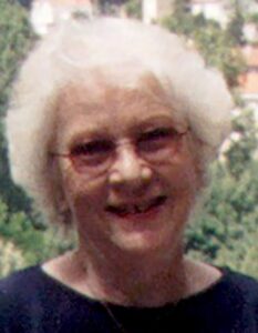
Kira Borisovna Shingareva (Photo by Henrik Hargitai)

We are very sad to inform you, that our colleague Kira Borisovna Shingareva passed away on Sunday, 15 September 2013.

The following text was taken from the book “Map Worlds: A History of Women in Cartography” by Will C. van den Hoonaard (Waterloo, ON: Wilfrid Laurier University Press, 2013, pp. 149–151):

Kira B. Shingareva, professor at Moscow State University for Geodesy and Cartography was Principal Scientist at the Planetary Cartography Laboratory and the Laboratory of Comparative Planetology at the Institute of Space Researches at the Academy of Science. She was one of the most eminent cartographers of extra-terrestrial bodies and was among the first people to succeed in mapping the “dark” (reverse) side of the Moon. She headed the Commission on Planetary Cartography of the International Association of Cartography.

Shingareva was born in 1938 in Russia. Her mother died when she was five years old. Her father was a chemical engineer. It was her father who suggested, at a critical point in her studies, that she should study mathematics in the university’s astronomical curriculum. She admitted that “she is forever grateful to him for that, loving him dearly.”

She studied in Dresden, Germany where she graduated from the Technical University in 1961 (at the age of 23), obtained a PhD in 1974, and a Dr of Science in 1992. Before then, she had gone to the University of Moscow. She wanted to become a mathematician and to study the theory of mathematics. During the exams she did not have enough points to be allowed to continue with mathematics (she just missed it by 1 point). As a consequence, she went to another university which included mathematics in the astronomical curriculum.

After having returned to Moscow from Dresden in 1962, she connected with a friend who was heading the Moon project, and he asked her to work for him at the Laboratory of Comparative Planetology at the Institute of Space Researches under the aegis of the Academy of Science. In October 1959, the Soviet Luna 3 had already succeeded in photographing the Moon’s far side. Three years after her arrival at the Institute, then at the University, she participated, in 1965, in the National Space program and mapped the Moon, Mars, Phobos, and Venus. As a 27-year-old, she was very excited to work on the project. Her main task was to select the landing sites for the moon probes. On 3 February 1966, Luna 9 was able to safely land on the Moon (the first-ever to do so) and take surface close-up images in the Oceanus Procellarum; Luna 13 was able to follow up on these images on 24 December in the same year (Williams, 2005: 2,3).

A turning point early in her career was the 1967 Congress of the International Astronomical Union (IAU) where she presented, for the first time, the nomenclature of the reverse side of the Moon. She was then only 29 years old. The Soviet presentation of Atlas Obratnoi Storony Luny, Ghast 2, 1967 (Atlas of the Far Side of the Moon, Part 2) at the Union failed on several accounts. Shingareva claimed, “the images were of bad quality and there were mistakes.” Ewen A. Whitaker (1999: 176), who was closely involved with the proceedings, noted that the map and a list of new names seemed like a fait accompli. Moreover, some 45% of the names were Russian. In any case, when the USSR delegation presented their nomenclature of the Moon, they faced opposition from the United States National Committee on Lunar Mapping and Nomenclature. It suggested that only numbers should be assigned to the 450 features on the reverse side of the Moon and that “we should be very conservative in assigning names,” and “use names of permanent renown” (Commission de la Lune, 1967: 104).

According to a participant in the tri-annual meetings of the IAU congresses in the 1960s, the controversy started a year earlier, in 1966, when Dr. A. Mikhailov of the USSR Academy of Science sent a letter to Dr. D. Menzel, President of the Lunar nomenclature Commission. Dr. Mikhailov suggested that “names of poets, painters, composers, etc. be used to identify the newly imaged craters on the Zond 3 photos” (Letter from Ewen A. Whitaker to W.C. van den Hoonaard, 28 March 2011). Later that year, the USSR published a list of 153 new names, of which some 66 were Russian, by-passing the rules of the IAU Lunar Nomenclature Committee.

When she presented her map, it became evident that the standards that applied to the near side of the Moon, could not apply to the far side. The near side showed the south pole on top of the map; the far side would show it at the bottom of the map. And where would “east” and “west” be (Whitaker, 1999: 173)? The United States scientists already had much information from their own lunar orbital photographic missions (1966–1967) involving 600,000 high-resolution images (Lunar and Planetary Institute, 2010), but the Soviets wanted her to select craters and name them. The scientists from Europe agreed with the approach taken by the Russian delegation.

After Shingareva had returned to Moscow, a United States colleague sent her a map with a small crater named “Kira” in recognition of her remarkable achievements. She always had that map on her wall. All of her grandchildren know about the Kira crater. She fondly recounts the story of a 102-year-old Russian lunar scientist, naming something after him and believing that he was dead. Soon, she received a letter from him, saying, “I’m very much alive!”  It is the International Commission of Nomenclature of the IAU that then ruled that one could now name craters after people who are over 100 years old! Shingareva was busy for 10 years at the USSR Academy of Sciences, participating in the Moon Exploration Project until 1977.

Kira B. Shingareva receiving an ICA award in 2007

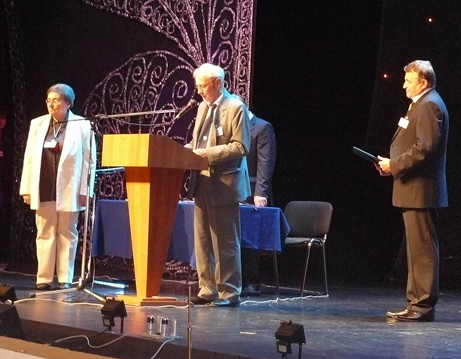
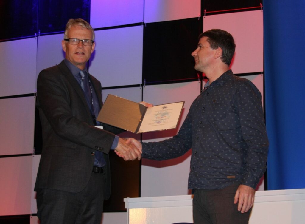
Kira B. Shingareva receiving the ICA Honorary Fellowship in 2007

More than 150 publications to her name, including “Atlas of Terrestrial Planets and their Moons” and “Space Activity in Russia – Background, Current State, Perspectives” (Karachevtseva et al., 2003), she was appointed as co-chairman of ICA Planetary Cartography Working Group, 1995–1999, Chair of the ICA Planetary Cartography Commission, 1999–2003, and, according to the Proceedings of the International Cartographic Conference, “managed such projects as a series of multilingual maps of planets and their moons, glossary on planetary cartography, and specialized map-oriented DB on planetary cartography in the frames of commission activity” (Shingareva, Karachevtseva, and Cherepanova, 2007). On the initiative of the Moscow State University for Geodesy and Cartography (MIIGAiK), several groups in Europe involving Shingareva were working on a Multilingual Planetary Map Series (Hargitai, 2004:150).

More recently, Shingareva has been trying to bring her graduate students to more earth-bound projects such as bringing her experience to bear, in 2006, on finding solutions related to the Moscow Megacity Road and Transport Complex (Sinitsyna and Shingareva, 2006).

Shingareva is well recognized. She was elected Honorary Fellow of the International Cartographic Association (ICA Newsletter, Dec. 2007: 5).

Please also read In Memoriam Kira B. Shingareva by her colleagues from the Commission on Planetary Cartography.

Pinhas Yoeli (1920–2011)

The International Cartographic Association is saddened to hear of the passing of Professor Pinhas Yoeli. In 2005 Prof Yoeli received an Honorary Fellowship from the International Cartographic Association.

Prof Yoeli was born on 1 July 1920 in Bayreuth, Germany. In 1936 he immigrated to Israel (then British mandatory Palestine) and, in 1938 he volunteered into the Israeli pre-state army, the Hagana. He later headed the Topography Department. In 1948, he established and commanded the Cartography Department of the Israeli Defense Forces (IDF) with the rank of Lieutenant Colonel. Later he was also appointed deputy director of the Israel Survey Department.

From 1952 to 1956 he studied at the faculty of Geodesy and Cartography at ETH in Zürich, Switzerland, where he received his degree (Dip. Ing. ETH). In 1957 he was released from the IDF and started teaching at the Israeli Technological Institute (Teknion) in Haifa, Israel. He quickly attained the post of Associate Professor and was appointed the head of the Department of Geodesy and Cartography in the Faculty of Civil Engineering.

In 1972 he was appointed Full Professor in the Faculty of Geography at Tel Aviv University. He worked until his retirement in 1991 when he became Professor Emeritus till his death on 4 April 2011. From 1988 to 1991 he was chairman of the Israeli Cartographic Association.

Over the years, Professor Yoeli was invited for Sabbaticals to many academic institutes and universities throughout the world, including Switzerland (teaching and researching at the ETH Zürich and the Zürich University), Australia (at RMIT), England and USA. In addition, he worked as a consultant to well known cartographic firms in Switzerland, Sweden and Scotland.

He published many papers in all major international cartographic journals. His book, Cartographic Drawing With Computers, the first in its kind, was published by the University of Nottingham, UK in 1982.

Professor Yoeli’s contributions to Cartography and GI Science are respected by the international academic and professional Cartography and GI Science communities. The awards he received in Israel and internationally for his research reflects the esteem in which he was held globally.

The International Cartographic Association extends its sincere sympathy to Professor Yoeli’s widow, Agnes, his family, friends and colleagues.

William Cartwright

Category: General News

Ingrid Kretschmer (1939–2011)

The long-time president of the Austrian Cartographic Commission, academic teacher of generations of cartography students at the University of Vienna and outstanding cartographic researcher Ingrid Kretschmer has passed away.

Ingrid Kretschmer was born in Linz, Austria, on 22 February 1939. Her academic career began in 1966 as university assistant at the Institute of Geography, University of Vienna under supervision of Erik Arnberger. She worked as university lecturer at the Institute of Geography and Regional Research of the University of Vienna till her retirement in 2004.

Ingrid Kretschmer dedicated her whole life to cartography both at university and scientific associations. She was a constant contributor to the Cartography and Geoinformation teaching during the long vacancies of the professorship of geography and cartography in the Institute.

Besides the administrative duties, Ingrid Kretschmer dedicated herself to education, in which the history of cartography, thematic cartography and school cartography were her specialisations. Many graduates remember the exactness and rigorous attention to the correct usage of professional terminology, which was characteristic of Prof Kretschmer.

The scientific work of Prof Kretschmer consists of 282 publications about fundamental issues and the history of cartography, as well as collaborations in editorial work. The most important among the numerous publications are Wesen und Aufgaben der Kartographie – Topographische Karten (Character and Duties of Cartography – Topographic Maps) in the encyclopedia Die Kartographie und ihre Randgebiete (Cartography and its Peripheral Areas) together with Erik Arnberger (1975), Lexikon zur Geschichte der Kartographie (Lexicon of the History of Cartography) together with Johannes Dörflinger and Franz Wawrik (1986) and Atlantes Austriaci in cooperation with Johannes Dörflinger and Helga Hühnel (1995). From 1977 to 1997 she was editor of the Geographischer Jahresbericht aus Österreich (Annual Geographic Report of Austria) and from 1996 to 2004 she was co-editor of Wiener Schriften zur Geographie und Kartographie (Viennese Writings in Geography and Cartography), founded by Ferdinand Mayer.

Besides the academic research and education, the Austrian Geographic Association and the Austrian Cartographic Commission were Prof Kretschmer’s fields of activity. She was active within the Austrian Cartographic Commission from the beginning of her academic career. She worked on numerous map exhibitions at international conferences and on the organisation of cartographic historical conferences. She was member of the editorial board and corresponding member of the editorial staff of Kartographische Nachrichten (Cartographic News). For more than 25 years she worked on Bibliographia Cartographica and was member of the Imago Mundi Board  of Directors since 1993.

Between 1997–2004 she was president of the Austrian Geographic Association and worked tirelessly in preparing the 150th anniversary celebration of the association in 2006 including the edition of the celebration bulletin. Due to her excellent achievements for the association, she was appointed honorary president of the association in 2006. Already in 1995 she became honorary member of the German Cartographic Association, from which she received its highest award, the Mercator Medal, on 13 October 2004.

Ingrid Kretschmer died in Linz on 22 January 2011, one month before her 72nd birthday. The funeral took place at Meidling cemetery in Vienna. Austrian, German and international cartography lost an adorable person, who dedicated herself and her whole life to cartography. We will miss her wealth of knowledge and energy. The Austrian Cartographic Commission lost one of its outstanding members.

Georg Gartner

Category: General News

Jacques Bertin (1918–2010)

Jacques Bertin was born in 1918 in Maisons-Laffite. He studied geography at La Sorbonne. In 1954 he created the Cartographic Laboratory of the École pratique des hautes etudes (EPHE) and became its director. Later he was director of the Graphics Laboratory of the École des hautes études en sciences sociales (EHESS), before becoming a researcher at the National Centre for Scientific Research (CNRS).

Jacques Bertin worked on the efficacy of thematic maps and their design improvements. He analysed visual effects on the transmission of information and the necessity for classification and application of hierarchy to data by means of different processes, including the ordered matrix. Bertin’s ground breaking research brought him international recognition, especially his work on semiotics and the subsequent publication of the famous Sémiologie Graphique. Les diagrammes, les réseaux, les cartes in 1967, with two new editions appearing in 1973 and 1999.

Jacques Bertin was the Chair of the Commission on Terminology of the French Committee of Cartography. He received the prestigeous Carl Mannerfelt Gold Medal at the 1999 ICA Conference in Ottawa, the highest award of the International Cartographic Association awarded to cartographers of outstanding merit who have made significant contributions of an original nature to the field of cartography.

He died in Paris on 3 May 2010.

In honour of Jacques Bertin and to celebrate his work and contribution to cartography, the French Committee of Cartography added two special sessions to the programme of ICC 2011 in Paris. On Monday, 4 July, Gilles Palsky will officially present Jacques Bertin’s life and work. Following this, different cartographers from around the world will present their research either inspired or influenced by Bertin. Last but not least, a special Café Carto dedicated to Jacques Bertin will be arranged.

Anne Ruas, Comité Français de Cartographie


Esri Press has recently republished Semiology of Graphics: Diagrams, Networks, Maps by Jacques Bertin.

This cartographic classic has continuously held its place of significance. Now, with a new epilogue written by the author shortly before his death, this new 2010 edition in English reawakens us to the information design possibilities of modern technology. Bertin was thrilled to know that this book would be coming out and that there was still immense interest in his work and dedication to keeping it alive. For ordering, visit esripress.esri.com/display/index.cfm.

Category: General News
rawboned-refined