Welcome to the International Cartographic Association
Welcome to the website of the International Cartographic AssociationGet to know the new ICA Executive Committee for the term 2023-2027Get to know the ICA Commissions for the term 2023-2027
Welcome to the website of the International Cartographic Association
Get to know the new ICA Executive Committee for the term 2023-2027
Get to know the ICA Commissions for the term 2023-2027

Georg Gartner is GeoAmbassador of the Month

Screen-Shot-2016-07-02-at-07.32.30“Geo for All” is an initiative of the Open Source Geospatial Foundation (OSGeo) with the mission for making geospatial education and opportunities accessible to all. It has developed out of the Memorandum of Understanding Activities between ICA and OSGeo.

Everyone who is interested in enabling geospatial education opportunities to all is considered a GeoAmbassador. It is not just the thousands of OSGeo members but also thousands of colleagues in ICA, ISPRS, UCGIS, AGILE, GSDI or AGS, who work for geoeducation opportunities. To further highlight their work, OSGeo now introduces GeoAmbassadors of the Month. ICA past-president Georg Gartner was appointed the first GeoAmbassador of the Month.

The laudatio by Suchith Anand can be found on opensourcegeospatial.icaci.org.

President’s Blog: ICA and OSGeo renew their Memorandum of Understanding

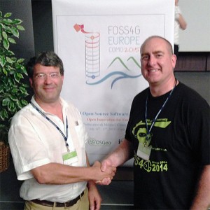
Georg Gartner and Jeff McKenna shake hands to renew the ICA-OSGeo MoU

Georg Gartner (ICA) and Jeff McKenna (OSGeo) shake hands to renew the ICA-OSGeo Memorandum of Understanding at FOSS4G-Europe in Como, Italy, on 16 July 2015

Based on the Memorandum of Understanding (MoU) between ICA and OSGeo signed in 2011, a real success story developed. The MoU acted as an umbrella for several activities coordinated by the ICA Commission on Open Source Geospatial Technologies under the chairmanship of Suchith Anand. The so-called ICA-OSGeo Labs are focussing on the use of open source software for geoinformation management and cartography. In the meantime, more than 100 institutions have joined the initiative and it is still growing. Based on the unexpected high interest, Suchith Anand took this idea a step further and founded Geo4All, which goes beyond open software and also includes the aim of having open access to education material, data and applications.

During the most successful FOSS4G Europe conference at Como, Italy, president of OSGeo Jeff McKenna and ICA President Georg Gartner renewed and edited the MoU, which can be found on wiki.osgeo.org.

– Georg Gartner
President of the International Cartographic Association

President’s Blog: Geo4All

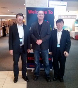
Prof. Chen Jun (ISPRS President), Jeff McKenna (OSGeo President) and Prof. Georg Gartner (ICA President) during their meeting at AfricaGEO in Cape Town in July 2014 to discuss future collaboration for GeoforAll

Prof. Chen Jun (ISPRS President), Jeff McKenna (OSGeo President) and Prof. Georg Gartner (ICA President) during their meeting at AfricaGEO in Cape Town in July 2014 to discuss future collaboration for GeoforAll

The “Geo for All” Initiative has developed out of the Memorandum of Understanding Activities between ICA and OSGeo (the Open Source Geospatial Foundation). So-called “ICA-OSGeo Labs” have been founded in unexpected high numbers in the last months (http://www.geoforall.org/locations/), demonstrating the great interest and demand for evaluating and using Open Source Software in the area of Cartography, GI Science and Geospatial Information Management.

In order to direct the development of this initiative an Advisory Board has been found, co-chaired by the Presidents of ICA (Georg Gartner) and OSGeo (Jeff McKenna). Due to the inclusive character of this initiative and a strong interest being expressed several times from the International Society for Photogrammetry and Remote Sensing (ISPRS) is now joining this initiative.

We are looking forward to working together in our common aim to expand geospatial education and opportunities to all.

Webinar on NASA World Wind and the Europa Challenge

The ICA-OSGeo Lab Network and MundoGEO are now pleased to inform the fourth webinar of the “Open Geospatial Science & Applications” webinar series on 13 February 2014. The webinars will be open and free to all on first come register basis.

This webinar will be on NASA World Wind and also on the Europa Challenge by Patrick Hogan (NASA) and Maria Antonia Brovelli (Politecnico di Milano, Italy).

Students might want to have a look at the NASA World Wind Europa Challenge. Apply now! You can see last year’s winning projects at http://eurochallenge.como.polimi.it/projects2013.

To register for the webinar please go to https://www2.gotomeeting.com/register/604781066.

The schedule for the next three ICA-OSGeo Lab webinar series is below:

Feb 2014

“NASA World Wind Virtual Globe Technology” – Patrick Hogan (NASA) and Maria Antonia Brovelli (Politecnico di Milano, Italy)
Thursday, 13 February 2014, 9:00 AM – 10:00 AM PST

March 2014

“Australian Urban Research Infrastructure Network ” – Chris Pettit (University of Melbourne, Australia)
7 March 2014 (time to be confirmed)

April 2014

“Things to do with OpenStreetMap” – Lluís Vicens (University of Girona, Spain)
Date to be confirmed

Previous webinars recording will be available at both the Geo For All website and at MundoGeo.

Advisory Board of the “Geo for All” initiative

We are pleased to announce the Advisory Board of the “Geo for All” initiative:

  • Professor Georg Gartner (ICA President & co-chair)
  • Jeff McKenna (OSGeo President & co-chair)
  • Professor Josef Strobl
  • Professor Marguerite Madden
  • Professor Mike Jackson
  • Sven Schade
  • Gavin Fleming
  • Sergio Acosta y Lara
  • Dr Chris Pettit
  • Professor Venkatesh Raghavan
  • Geoff Zeiss
  • Jeroen Ticheler
  • Phillip Davis
  • Arnulf Christl
  • Professor Maria Brovelli
  • Dr Rafael Moreno

The ICA-OSGeo Lab network is a joint initiative of the Open Source Geospatial Foundation (OSGeo) and the International Cartographic Association (ICA). The ICA and OSGeo Presidents will be the co-chairs and permanent members of the Advisory Board. Others will have a 3 year term starting date of the Advisory Board being constituted (1 Dec 2013). The Advisory Board has brought together an excellent range of expertise (academia, government, industry) and geographical distribution (we have nearly all continents covered). Also it brought together members from other key communities ISPRS, AGILE, INSPIRE, UNIGIS etc which will make sure is it a fully inclusive global initiative. The Advisory Board will meet once every six months by telemeeting and AB members will keep an eye on the developments and provide strategic advice to the initiative through various forums.

While there has been tremendous growth in geospatial technology over the last few decades, the number of universities offering courses in geospatial science has not kept pace. Free and open geographic information (GI) software helps make geospatial education available to students from economically poor backgrounds worldwide (removing the need for high cost proprietary GI software). Our key aim is to make it possible for students in developing and poor countries to be also able to get geospatial education. This initiative will bring more opportunities for geospatial education worldwide. Over 50 Open Source Geospatial Labs have already been established in universities around the world as part of this initiative in just two year’s time, and we will be establishing over 100 research labs worldwide by September 2014.

We will have over 500 labs established worldwide in the next five years making us the biggest geospatial education and research network on the planet and we now have a good team of experts to guide us for the future. Welcome to all members of the Advisory Board and we are looking forward to their advice and ideas for expanding this education initiative globally!

We thank all of you for your strong support for this education initiative and it is very happy for us that our initiative has now grown rapidly from very humble beginnings and is helping to widen the benefits of geospatial education opportunities to thousands of students worldwide.

Suchith Anand

Website of Geo for All: http://www.geoforall.org/

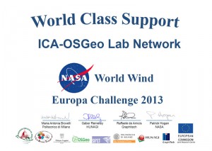
ICA-OSGeo awarded for support provided for the NASA World Wind Europa Challenge

The ICA-OSGeo Lab Network was awarded for the support provided for the NASA World Wind Europa Challenge.

The first edition of NASA World Wind Europa Challenge achieved its objective of inspiring ideas for building great applications that serve the INSPIRE Directive and uses NASA’s open source virtual globe technology World Wind.


Tag: , ,

First Australian Open Source Geospatial Laboratory to Support Smarter Cities will be built at the University of Melbourne

The University of Melbourne will be home to Australia’s first Open Source Geospatial Laboratory. The laboratory will support urban research and educational excellence through the use of location based (geospatial) data and tools.

The Laboratory will undertake research and provide training resources which utilises digital data and analytical and visualisation tools to up-skill a myriad of disciplines in evidenced based decision-making practices. Training will be delivered both into existing University curriculum and through a series of workshops and short-courses.

The laboratory is expected to attract considerable interest from urban geographers, spatial scientists, planners and policy-makers who are keen to contribute to and learn about the latest available data driven techniques to support evidenced based decision-making. The laboratory will utilise the Australian Urban Research Infrastructure Network (AURIN). AURIN is a $20 million open source e-infrastructure initiative which is unlocking datasets of relevance to Australia’s cities and providing an analytical toolkit to inform sustainable urban futures.

The software used to support activities of the laboratory is open source, meaning the source code can be modified and re-distributed royalty and fee free. This open source geospatial laboratory is a joint initiative of the International Cartographic Association (ICA) and the Open Source Geospatial Foundation (OSGeo).

The laboratory will see scientists and practitioners from the International Cartographic Association (ICA) and the Open Source Geospatial Foundation (OSGeo) collaborate closely with University colleagues. This Australian facility will be part of a global network of open geospatial research labs known as ICA-OSGeo labs. Currently there are 22 ICA-OSGeo labs operating globally.

Dr Christopher Pettit, Associate Professor at the University of Melbourne, Victorian Chair of the Surveying and Spatial Sciences Institute (SSSI) and Strategic Implementation Coordinator of AURIN will lead the initiative.

“The University of Melbourne is one of the top research universities in the world and has been a pioneer in Australian geospatial science research,” said Professor Tom Kvan, Dean of the Faculty of Architecture, Building and Planning. “We are delighted to collaborate with the ICA and OSGeo to create this opportunity for our students and researchers, which will encourage open geospatial teaching and related research in other universities.”

The facility will open in September 2013.

Further Information

Dr Christopher Pettit
The University of Melbourne
Email: cpettit@unimelb.edu.au
Phone: +61 422 301 832

Dr Suchith Anand
University of Nottingham
Phone: +44 (0)115 84 32750
Email: suchith.anand@nottingham.ac.uk

OSGeo is a not-for-profit organisation founded in 2006 whose mission is to support and promote the collaborative development of open source geospatial technologies and data.

ICA is the world authoritative body for cartography, the discipline dealing with the conception, production, dissemination and study of maps.
Introducing the ICA-OSGeo Lab Network

After discussing with our lab members, I am pleased to inform that we now have the official name and also a short acronym for our network of Open Source geospatial laboratories: ICA-OSGeo Lab Network is the official title of the network and OSGL as the acronym to be used for the url, domain name, etc.

The official full title highlights and brings together two communities – the ICA and the OSGeo (Open Source Geospatial Foundation) – in our common aim to support the establishment of Open Source Geospatial Laboratories and Research Centers across the world for supporting development of open-source geospatial software technologies, training and expertise. We started establishing the network of labs globally with the ICA-OSGeo MoU initiative.

Individual labs (those already established and those in future) are free to select the names they wish. For example, the lab at UNMC is called Open-source Geospatial Research Lab, at NCSU it is OSGeo Research and Education Laboratory (OSGeoREL), it is Open Source Geospatial Lab in Newcastle University, etc. That will also give individual nodes the flexibility to select the name for their lab that they want under a joint lab network umbrella.

We are also working to create a dedicated website and mailing list. In the meantime, visit the OSGeo page on education intiatives for details.

We would like to thank the whole OSGeo and ICA community for the strong support and helping spreading the message of our education initiative.

Best wishes,
Dr Suchith Anand

rawboned-refined