Welcome to the International Cartographic Association
Welcome to the website of the International Cartographic AssociationGet to know the new ICA Executive Committee for the term 2023-2027Get to know the ICA Commissions for the term 2023-2027
Welcome to the website of the International Cartographic Association
Get to know the new ICA Executive Committee for the term 2023-2027
Get to know the ICA Commissions for the term 2023-2027

Report of the 13th Mountain Cartography Workshop

The 13th ICA Mountain Cartography Workshop, organized by the Commission on Mountain Cartography (CMC), was held April 3-7, 2024 at the base of Poland’s Tatra Mountains.

Workshops are usually held biennially, alternating with the International Cartographic Conferences (ICC). This year, CMC workshop got back on this traditional schedule, after the 12th ICA CMC Workshop in the Colorado Rockies needed to be rescheduled twice due to the COVID-19 pandemic. It was originally scheduled for April 2020, then initially rescheduled to April 2022, and finally convened in April of 2023.

The workshop organizer was Rafał Jońca of AMG Maps. CMC Chair Patrick Kennelly supported the team in preparation of the workshop, and previous workshop organizer Tom Patterson and ICC liaison Dušan Petrovič provided plenty of logistical support. Tom Patterson was especially helpful in building the web site for the workshop, as well as answering numerous questions about how we could recreate the success of the Colorado 2022 ICA CMC workshop.  We selected Limba Grand & Resort as the workshop venue because of its proximity to Krakow, Poland (about three hours away by train or car), and for its beautiful mountain setting. Limba Grand & Resort is near the city of Zakopane and within easy reach of the Tatra Mountains that serve as the southern border of Poland with Slovakia.

The workshop had 36 participants from Poland, Austria, France, Germany, Greece, Croatia, India, New Zealand, Portugal, Romania, Slovenia, Switzerland, and the United States. Five of the participants were female and five were students.

The theme of this year’s workshop was “Mapping Mountains in a New Era” to focus on how we approach mapping mountains, and how this focus may change in the coming years. The workshop featured 23 presentations grouped into 7 sessions. Rafał Jońca organized the program and was flexible in accommodating the needs of speakers both before and during the workshop. He asked several younger participants to chair sessions with the goal of making them feel welcome and involved.

The workshop began on Wednesday evening with welcoming remarks from Rafał Jońca and Patrick Kennelly.

This was followed by a social time in our spacious dining room, which the Limba Grand & Resort allowed us to use in addition to our meeting and recreation rooms. A downstairs great room provided access to pool, ping pong, and foosball tables for evening recreation. Nearby was a third room we had available to us for social gathering. Our meeting room had all the needed equipment for presentations, and also served as a map and poster gallery.

Thursday and Saturday were devoted to presentations covering a variety of topics related to mountain cartography. Presentations were either 10 or 20 minutes in length. Thursday evening after dinner opened with shorter Avalanche Talks by presenters who discussed their poster contributions. This year, all five Avalanche Talks were given by undergraduate students from Middlebury College in Vermont, USA who completed their posters as part of a Senior Seminar with their professor, Jeff Howarth, who unfortunately was not able to attend. Many participants noted these beautifully designed and thought-provoking posters, along with the interesting and engaging overviews from the students’ Avalanche Talks, as a highlight of the conference. This session was followed by the CMC business meeting which was run by CMC Chair Patrick Kennelly.

Friday was the Field Study Day. The purpose is for participants to get to know both the beautiful mountain setting of the Tatras and one another better in a more informal manner. Participants had three options. Rafał Jońca led a cultural tour of Zakopane and its environs, including city center of Zakopane, with a focus on local wooden architecture in Zakopane’s style and an old cemetery of Zakopane. The tour also included a funicular to a stunning view of the Tatras and Zakopane. After organizing transportation to the nearby Tatra National Park for all interested participants, Dušan Petrovič led a field study to the iconic Morskie Oko, while Charly Kriz led other participants on a hike to a spectacular viewpoint of the Tatras.

Upon returning to the Grand Limba & Resort, the last activity on Friday was the always challenging mountain trivia quiz hosted by Tom Patterson. The winning team (Alex Fries, Karel Kriz, Dušan Petrovič, Ondrej Prochazka, and Silviu Bumbak) scored 20 out of 27 possible points.

The workshop continued on Saturday with additional presentations. Also, Dušan Petrovič, our liaison on the ICA Executive Committee, provided an overview of the ICA and other items that were of interest to the CMC attendees. He also presented two attendees with Young Scientist Scholarships to assist in their travel costs, Madeline Grubb from the United States and Shekhar Kumar from India.

ICA scholarship awardee Madeline Grubb from the US

ICA scholarship awardee Madeline Grubb from the US

ICA scholarship awardee Shekhar Kumar from India

ICA scholarship awardee Shekhar Kumar from India

The workshop concluded Saturday evening with a night out in Zakopane at the Góralski Browar, a fun and festive conclusion to the workshop.

The workshop program, CMC business meeting notes, and other information are available on the CMC website at https://mountaincartography.icaci.org, and all photos in this report are courtesy of Charly Kriz and Dušan Petrovič.

Rafał Jońca, Patrick Kennelly, and Dušan Petrovič

Invitation to CartoVis 2024 – ICA Workshop on AI, Geovisualization, and Analytical Reasoning

The University of Warsaw Department of Geoinformatics, Cartography, and Remote Sensing in collaboration with the International Cartographic Association Commissions on Cognitive Issues in Geographic Information VisualizationGeovisualization, and User Experience (UX), as well as ICA Next Generation Cartographers Working Group are pleased to invite you to the 2024 ICA Workshop on AI, Geovisualization, and Analytical Reasoning, on Saturday, 7 September 2024 at the University of Warsaw, Poland.

Early-stage work is explicitly encouraged, especially by junior scholars or those new to cartography.

We invite you to contribute to our Call for Papers. Short papers (2 pages) can be submitted until 15 May 2024 and abstracts (300 words) until 1 June 2024. Submissions are expected to report on ongoing and emergent work that aims to tackle one of the many dimensions of cartography: specifically, we welcome those that relate to supporting geovisualization and analytical reasoning, including approaches that leverage AI methods applied at various stages: data processing, analysis, visualization generation and interpretation, as well as support in user perception interpretation. Broadly speaking, we are seeking work that focuses on understanding users, their cognitive processes, and/or their interactions with visual representations and computational methods via maps or geographic visualization. We welcome research that tackles these and related problem areas through computational, representational, artificial intelligence (AI), ethical, or contextual methodological lenses. This workshop will provide a forum in which new approaches and ideas can be discussed and where new research collaborations can be formed.

There will be no conference fee!

For details please visit our workshop website: http://carto-vis-workshop.uw.edu.pl/ 

We are looking forward to your contributions and to welcoming you to Warsaw!

CartoVis24 Organizers

Tag: ,

First Call For Papers: 2020 ICA Workshop on Analytical Reasoning for Cartography, Visualization, and Design


Date: Monday 14 September 2020 (ahead of GIScience 2020)
Location: University of Warsaw | Warsaw, Poland
Workshop website: http://carto-vis-workshop.uw.edu.pl/

Purpose

It has been 15 years since visual analytics was first established as the science of analytical reasoning facilitated by interactive maps and visualizations. Since then, new models have been proposed to understand cognitive reasoning processes, new technologies have been released to support interactive, mobile, and immersive mapping, and new methods have been developed to examine and evaluate user experiences with analytical support systems. We call for research papers in cartography, visualization, and allied design fields to capture the state-of-science on visuospatial analytical reasoning.

Analytical Reasoning goes beyond simply noticing a pattern, and invokes a complex set of processes that aim to explain what has been seen, or to predict what will happen next. Creating the conditions in which users are able to reason about spatial information is a difficult task, and there are many challenges to overcome. This workshop invites short reports on ongoing and emergent work that aims to tackle one of the many dimensions in cartography that relate to supporting analytical reasoning. Broadly speaking, we are seeking work that focuses on understanding users, their cognitive processes, and/or their interactions with visual representations and computational methods via maps or geographic visualization. We welcome research that tackles these and related problem areas through computational, representational, or contextual methodological lenses. This workshop will provide a forum in which new approaches and ideas can be discussed and where new research collaborations can be formed.

Early stage work is explicitly encouraged, especially by junior scholars or those who might be new to cartography.

This workshop represents the joint efforts of the University of Warsaw Department of Geoinformatics, Cartography, and Remote Sensing in collaboration with the International Cartographic Association Commissions on Cognitive Issues in Geographic Information VisualizationVisual Analytics, and User Experience (UX).

Format

We invite two kinds of contributions. First, we seek two-page short papers on completed research. Two-page short papers should be prepared using the CHI format, with accepted papers receiving 20 minutes for presentation and discussion. Second, we seek 150-word abstracts on work in progress or early graduate proposal ideas. Short abstracts will receive 5 minutes for a lightning talk presentation with discussion following all lightning talks. Select papers may be encouraged for expansion into a special journal issue, depending on participation.

Short papers and abstracts will be reviewed by two program committee members to gauge appropriateness for the workshop.

Relevant topics include:

  • Geovisualization and visual analytics
  • Storytelling for improved comprehension of geographic processes
  • User experience design for expert systems
  • Visuospatial cognition and reasoning
  • Models of spatial cognition
  • Models of human visuospatial reasoning
  • Individual and group differences in spatial abilities
  • Wayfinding and navigation
  • Reasoning on the go with augmented and mixed realities
  • Thematic map design
  • Visual variables and visual semiotics
  • User perspectives on thematic cartography
  • Human-computer interaction
  • Immersive analytics
  • Understandable machine learning
  • Algorithms and spatial decision making
  • Spatial decision support systems

Submission Details & Important Dates

Papers and abstracts should be submitted using our EasyChair site located at: https://easychair.org/conferences/?conf=cartoviz20

  • 2-page paper deadline: 15 May 2020
  • Short abstract deadline: 1 June 2020
  • Notification of acceptance: 15 June 2020
  • Registration deadline: 31 July 2020

If you need a visa to Poland to participate, or have other questions about the workshop, please contact the local organizers at carto-vis-workshop@uw.edu.pl.

Registration

Please visit our workshop website for registration details: http://carto-vis-workshop.uw.edu.pl/

Tag: ,

President’s Blog: Website feedback and a map poem

The relaunched website has caused an impressive number of positive reactions, including a note in the “Kartographische Nachrichten”, the Journal of the German Cartographic Society, where the Editor Rolf Harbeck refers to the relaunched ICA website as the probably “richest source for information on the international community of cartography”. He also highlighted the use of modern web technology. The new added LinkedIn – Group option (have a look at the small blue button “in” on the top right part of the ICA website) has helped ICA to reach out in only two weeks time to many who share interest in ICA topics but have not found the right instrument yet to get in contact. Interested? Try it and share it!

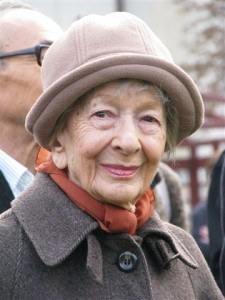
Our polish colleague Beata Medynska-Gulij has informed us about the passing away of the polish poet and nobel prize winner for literature (in 1996) Wisława Szymborska in February 2012. The last poem she finished before her death is called “Mapa” (“the map”). I would like to share a draft translation of the first and third part of the poem, done by Agata Ciolkosz-Styk from the Institute of Geodesy and Cartography Warsaw, with you:


Wisława Szymborska

Wisława Szymborska, 2009,
photo by Mariusz Kubik

THE MAP

by Wisława Szymborska (2012)

Flat as a table,
On which it is put.
Nothing moves underneath it,
Nothing changes its place.
Above it – my human breath
Does not create vortexes of air
And nothing muddies its pure colours.

I like maps, because they lie.
Because they do not give an access to the virulent truth.
Because generously, with good-natured sense of humor
They spread on a table in front of me the world
Not of this world.


Tag: ,

Honorary Fellowship for Andrzej Ciolkosz

Prof. Dr. Andrzej Ciolkosz is an outstanding cartographer whose activities have centered on the application of air photography and satellite images in cartography. He was an organizer and head of the Polish National Remote Sensing Centre in the Institute of Geodesy and Cartography, whose mission is the use of remotely sensed data in thematic cartography. He is the author of some two hundred papers, reports, and maps. He is a member of the Polish Association of Cartographers.

Prof. Ciolkosz was a Vice-President of the International Cartographic Association from 1978 to 1984 and was Chair and Deputy Chair of the ICA Commission on Thematic Mapping with the Aid of Satellite Imagery. He contributed to Annotated Bibliography on Application of Satellite Images to Thematic Mapping and to the guidebook Thematic Mapping from Satellite Imagery published on behalf of ICA by the University of Waterloo (Canada) and Elsevier Science. He was Chair of the Local Organizing Committee for the ICA conference that was held in Warsaw in 1982.

Prof. Ciolkosz is still very active in research and teaching in remote sensing and cartography at Warsaw University and Nicholas Copernicus University in Torun.

For his many contributions to ICA and to the application of remotely sensed imagery in cartography, Prof Ciolkosz is awarded an ICA Honorary Fellowship.

Category: General News
rawboned-refined