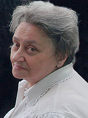
 On November 20, 2005 will be the centenary jubilee of Konstantin A. Salichtchev – the well-known Russian cartographer, who did a lot for the development of cartographic science and the International Cartographic Association (ICA).
From 1956 till 1972 he chaired the Commission for National and Regional Atlases of the International Geographical Union; in London/Edinburgh (1984) he was elected Vice-President of ICA, and in Delhi (1968) President for the next 4-year period.
The activities of Prof. Salichtchev were focused on geography and cartography. When young, he actively participated in expeditions to North-East Asia under the leadership of S. Obruchev. As a result of this work which was carried out from the end of the 1920’s till the middle of the 1930’s, detailed maps of the Anadyr, Kolyma and Indigirka river basins and a considerable part of Chukotka were produced. The discovery and mapping of the Chersky mountain-range and of the ‘pole of cold’ near Oimyakon were the most important results of the research during that period. The world community got acquainted with these studies through Salichtchev’s publications of 1933–35 in Petermanns Geographische Mitteilungen and in the Geographical Review.
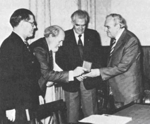
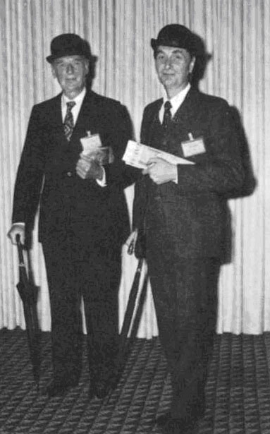
Presentation of Mannerfelt Medal to Professor Salichtchev, Moscow 1981. From right to left, Salichtchev, Komkov, Ormeling and Hedbom
The compilation of the Great Soviet Atlas of the World was the next stage of his work (1936–38). Since then he was deeply interested in atlas theme for all his life. He chaired the editorial board of the Atlas on the History of Geographic Discoveries and Investigations (1959) and was a member of editorial boards of the Sea Atlas (1950–53), Physical-Geographical Atlas of the World (1964) and Atlas of Oceans (1974–80).
Prof. Salichtchev was the author of many articles dealing with atlas mapping. Among the most fundamental results of activities of the IGU National and Regional Atlases Commission chaired by Prof. Salichtchev for 16 years were the monographs National atlases: their history, analysis, ways of improvement and standardisation (1960 in Russian and French, 1972 in English) and Regional atlases: trends of development, content of maps of natural conditions and resources (1964 in Russian and English).
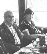
Professor and Mrs. Salichtchev aboard Wolga steamer during conference excursion 1976.
Prof. Salichtchev initiated the organization of the Laboratory of Integrated Mapping at the Moscow State University Faculty of Geography in 1964. A number of scientific and reference atlases have been created there: of Irkutsk oblast (1962), Kustanay oblast (1964), Northern Kazakhstan (1971), Tumen oblast (volume 1 – 1971, volume 2 – 1976), Altai Territory (volume 1 – 1978, volume 2 – 1980). Recently, the Environmental Atlas of Russia (2002) was compiled there, as well as a series of atlases for secondary; the Atlas of Khanty-Mansi Okrug is being prepared there now for publishing. The Laboratory rendered methodological assistance in the creation of the national atlases of Moldavia, Kirgizia, Uzbekistan, Tadjikistan and Lithuania, and of atlases of the oblasts of Perm, Tomsk, Sakhalin and others.
In 1974 the Laboratory started a new fundamental research on maps for high schools, as Prof. Salichtchev came to chair the Scientific and Editorial Council on maps for high schools. The work has resulted in the series of general geographic and thematic maps of the World (1:15 000 000), the USSR (1:4 000 000 and 1:8 000 000), the European part of the USSR (1:2 000 000), foreign countries of Eastern Europe (1:1 000 000), geographic maps of the world, continents and of regions of the USSR as well as the series of educational topographic maps at different scales. By 1996 7 thematic maps of the world, 21 maps of the USSR and its regions, 4 maps of East-European countries, 12 general geographic maps and 6 sets of topographic maps had been created.
Prof. Salichtchev always took a keen interest in the theory and methodology of cartography which became the topic of many articles and of a monograph (Salichtchev K.A. Ideas and theoretical problems of cartography of the 1980s. – M.: VINITI of the USSR Academy of Sciences, 1982, v. 10, 156 p.). He actively upheld his views and ideas in polemics with foreign and Russian cartographers and geographers. In 1967 he became the laureate of the Anuchin Prize for his works on the theory of cartography.
He suggested the idea of using maps to get knowledge about the environment. His first article on this topic was published in 1948, and he discussed this idea for many times (see the bibliography of Salichtchev’s works for 1955–1984 in the anniversary collection of papers Geographical Cartography, a look at the future. Ed. by G.I. Rychagov, A.M. Berlyant, V.S. Tikunov. M., MSU, 1986, and other publications till 1988).
He was always ready to respond to new ideas and trends in cartography, such as cartographic modelling or the application of remote sensing methods for thematic mapping, and a great number of his contributions concerned the prospects of automation in cartography – it is on this base that the development of geoinformation science started in Russia.
Textbooks by Prof. Salichtchev were translated and published in China, Germany, Poland and Cuba. His textbook Basics of cartology was rewarded with the Golden Medal of N.M. Przhevalsky (1963) and in 1984 it was rewarded with a second Golden Medal. Prof. Salichtchev was honorary member of scientific societies in the USSR, Azerbaijan, Serbia, Columbia, Scotland, Poland, USA, Bulgaria, Italy and Hungary and Honorary Doctor of Berlin’s Humboldt University and Warsaw University. He was the laureate of many awards both in Russia and abroad. Prof. Salichtchev was one of the first to receive the Carl Mannerfelt Medal, in 1980, which is awarded by the ICA for outstanding achievements in the international collaboration of cartographers. In 1965 he was nominated Honored Scientist of Russia.
He was also awarded the State Prize of the USSR for his contribution to the compilation of the Atlas of Oceans (1980).
We would like to recall our personal contacts with Prof. Salichtchev:
Milan Konecny
The first time I met Professor Salichtchev in Moscow, MGU was in 1980 at his office. At that time I was going through a 3-month stage in the Geographical faculty, dividing my interests between anthropogenic geomorphology and cartography. I used many mathematical-cartographic approaches started by prof. Salichtchev and further developed by his successors. At the time of our meeting, Prof. Salichtchev was a pleasant and attentive host, but in matters of cartography he was very convinced of his own truth. His ideas were based on the “Theory of reflection” but at the same time he looked also into philosophical sources from all parts of the former USSR and abroad.
He had an excellent cartographical overview of domestic, European and World development and he was a very temperamental disputant.
As a former president of ICA, he had a very good reputation in both parts of the world divided by the iron curtain. He was also a strong symbol of cartography in the former Central and Eastern Europe.
Very interesting were Prof. Salichtchev’s comments and ideas on the coming “scientific-technological revolution”. His school was prepared for the new technological situation by developing the idea of mathematical-cartographical modelling, the role of satellite images in cartography, discussions about the role of the map image as a resource for data and information for geographical research as well as research in other scientific disciplines. In personal talks he welcomed new technologies and expected them to bring new and progressive development of cartography, but at the same time he stressed that cartography had to take care about the content and quality of data and information. He did not expect any crises of cartography at the end of 80s and 90s when our science lost its previous strong positions and did not deal well with new technologies like GIS, remote sensing, GPS and others. Today the importance of cartography is growing up again.
Globally operating companies need cartographical methodology and knowledge for the time when ambient technologies are coming, big GIS vendors again invest millions of dollars into the development of cartographical tools. The question how to use cartography effectively for cartographic visualisation and representation of geographic data, information and knowledge on the basis of so called SDIs is the topic of the day on most of the continents. And also here Prof. Salichtchev is with us. His ideas to create maps and atlases according to unified legends, at the same scales, his thoughts about necessary creation of metadata were in fact ideas about “SDIs” in cartography. In his time the World was different and our societies and various communities were not sufficiently prepared. Therefore, some of his ideas are realized today simultaneously with the development of Information/Knowledge-Based Societies and as well as in different political, economical and social conditions compared to Salichtchev’s times. I am certain that if he was still with us nowadays, he would have been preparing a representative presentations of Russian cartography for the coming ICC’s in A Coruna (2005) and Moscow (2007). Prof. K.A. Salichtchev was one of the best cartographers in the world and contributed a lot to development of the world cartography.
Ferjan Ormeling
The first time I participated in a conversation with Prof. Salichtchev was when he visited our home in 1967, during the Amsterdam ICA conference. I still remember that he was rather skeptical at the way my father had acquired this house, and did not believe my father’s claims that he had earned it himself; university professors were well-paid at the time in the Netherlands. The second time was in 1976, during the Moscow ICA conference. In 1974 I had published a paper on 50 years of Soviet Cartography (1917–1974), that had been translated in The American Cartographer, and that claimed, as an aside, that there were conscious distortions on those topographical maps and town plans of the USSR, that were available to foreigners. This publication was rather awkward for my father who at the time was Secretary-General of the ICA, and who hastened to tell Salichtchev (who was organizing the next ICA conference in Moscow) that it was not he who had written the article (we have the same initials). Salichtchev had not forgotten this and when he saw me next in Moscow he told me he found my contribution rather unscholarly. But this did not detract from my admiration for him: for me he was a man of grand ideas, and the best one was his on national atlases.
You see, Salichtchev worked for a long time on the unification and standardization of national atlases. He initiated studies on the scales and on the legends of the various map themes these atlases contained: economic maps, traffic and transportation maps, manufacturing maps, etc. And the grand idea behind all this was, that if all these aspects (scales and map legends and ways of presentation) of national atlases would be standardized, then we would – by putting these atlases side by side – have one big thematic atlas of the world.
It is only now that, through the new digital possibilities we have at our disposal that we are finally able to make this dream of Salichtchev come true, but that does not diminish his endeavours: as a visionary he showed us the directions where to go!
Vladimir Tikunov
The first time I saw Prof. Salichtchev in 1966, when I became a student of Geodesy and Cartography Department he was the head of. And I was fortunate enough to maintain good contacts with him till his death in 1988. His wide knowledge and, above all, fantastic dedication to work always produced a tremendous impression. He acquired information for his articles and textbooks grain by grain working without holidays and vacations, usually from 4 or 5 in the morning – “when everyday concerns do not pull you away”, as he often explained.
However it might be well to point out that he took an interest in many other aspects of life. He was, among other things, an expert in painting and chinaware and had a good collection of it. Famous galleries, such as Tretyakov, for example, and large exhibition halls of this country asked him from time to time to exhibit some of his works. He collected post stamps too, with map images, of course. When I was in London in 1977–78 for training at the Experimental Cartographic Unit of the Royal College of Arts (the idea was initiated by Prof. Salichtchev and I’m still grateful to him for it) he personally asked me to bring him some particular post stamps he was interested in. He also was an expert in Georgian wines and dishes. Of course he had a large collection of maps and atlases and was very proud of it. Although Prof. Salishchev looked cool and restrained, he could talk with colleagues and even students for hours. And his eyes shone when he managed to have a look at old maps which were another passion of him. During his visits abroad, which unfortunately never took very long, he spent a lot of time in libraries and book depositories, feeling enjoyment from working with maps which had been inaccessible to him before.
All together we’d like to thank our lucky stars for the chance to have had contacts with Professor Konstantin A. Salichtchev.
Milan Konecny, ICA President
Ferjan Konecny, ICA Secretary General
Vladimir Tikunov, ICA Vice-President