Welcome to the International Cartographic Association
Welcome to the website of the International Cartographic AssociationGet to know the new ICA Executive Committee for the term 2023-2027
Welcome to the website of the International Cartographic Association
Get to know the new ICA Executive Committee for the term 2023-2027

News about the Barbara Petchenik Competition

Music video with maps submitted to previous competitions

Some days ago a Spanish ethnomusicologist, pedagogue and composer, Polo Vallejo (Pedagogy Professor in the Superior School of Music Reina Sofía, Madrid) asked for permission to use some of the map drawings made by children for the Barbara Petchenik competition in a short music video. His idea was to accompany maps made by children with a children xylophone piece of Carl Orff (German composer). Permission was given and the video is now available here: https://www.youtube.com/watch?v=CsetAhhMSNE

The video is used as a greeting card directed to music associations all over the world.

The ICA Commission on Cartography and Children would like to thank Polo Vallejo for this lovely pre-Easter gift!

Selecting a new theme for the next competitions

Next September the International Cartographic Association (ICA), represented by the Commission on Cartography and Children plans to announce the Barbara Petchenik Competition 2021. In 2016 we decided to support the International Map Year using “We love maps” as theme for the competitions in 2017 and 2019. Now it is time to select a new theme for the competitions to be held in 2021 and 2023. We asked by e-mail all the members and supporters of ICA Commissions, all the representatives of ICA member nations, all the representatives and members of sister organizations and all colleagues in general to propose themes for the next two competitions. The organizers of the competition are open to any theme that can be represented by children on their maps. As help, here we list some of the themes selected for previous competitions: “Save the Earth”, “Many nations, one world”, “Living in a globalized world” and “My place in today’s world”.

We would ask colleagues to send their proposals to the jesusreyes@caesar.elte.hu e-mail address at latest on May 15. After the deadline, the commission is going to organize a voting process on the web, asking colleagues to vote their preferred themes and according to the number of votes, we select only one theme for the Barbara Petchenik Competitions in 2021 and 2023.

If you wish to have more detailed information about the Barbara Petchenik Competition, please visit the sites: https://icaci.org/petchenik/, https://childrensmaps.library.carleton.ca/ or http://lazarus.elte.hu/ccc/2019icc/bpcrules2019.pdf


José Jesús Reyes Nunez
Commission on Cartography and Children, Vice-Chair

Atlases in Time – Joint Commission Meeting in Madrid 2020 postponed to October

Please note: Due to the very uncertain situation caused by the emergence of the Corona virus, the local organizing committee together with the commission chairs decided to postpone the meeting in Madrid (original date: 22.–25. April).

The new date of the Joint Commission Meeting in Madrid will be 14.–17. October (Wed–Sat).

Further information is available through the Madrid2020 conference website: https://map-service.de/madrid2020/

Tag:

Atlases in Time – Invitation to Joint Commission Meeting in Madrid 2020

Please note: Due to the very uncertain situation caused by the emergence of the Corona virus, the local organizing committee together with the commission chairs decided to postpone the meeting in Madrid. The new date of the Joint Commission Meeting in Madrid will be 14.–17. October (Wed – Sat).

Further information is available through the Madrid2020 conference website: https://map-service.de/madrid2020/

On the occasion of 150 year anniversary celebration of the National Geographic Institute of Spain (IGN) – the publishing institution of the National Atlas of Spain – the ICA Commission on Atlases and the ICA/IGU Commission on Toponomy together with the IGN organize a symposium on Atlases and Toponomy from the 21 to the 25th April 2020 in Madrid. During three sessions questions concerning evolving dissemination concepts and techniques for atlases, recent development and examples of National Atlases as well as related important toponomastic issues will be discussed.

Date: 22.–25. April 2020
Venue: Instituto Geográfico Nacional (IGN), Madrid, Spain
Good to know: The Symposium is FREE OF CHARGE!

Call for Abstracts

Presentations will be held in a classic 20 min format of 15 min talk and 5 min discussions, and also in a 5 min lightning format, where you can bring in specific challenges (not solved yet) or new ideas. A publication of the contributions as papers or abstracts will be realized.

Deadline for Abstract Submission: 15. February 2020
The abstract should not exceed 500 words and can be submitted as .docx or .pdf-file.

Abstract submission, a preliminary timetable and further information can be accessed via the symposium website: map-service.de/madrid2020

Online Registration will open in February 2020.

Tag: ,

Invitation to the 13th ICA Conference on Digital Approaches to Cartographic Heritage

The Commission on Cartographic Heritage into the Digital, continuing the tradition of its annual Cartoheritage Conferences, since 2006, is organising the 13th Conference Digital Approaches to Cartographic Heritage (ICA DACH) in Madrid, Spain, 18-20 April 2018, in partnership with the IGN – Instituto Geográfico Nacional, supported by the SECFT – Sociedad Española de Cartografía, Fotogrametría y Teledetección, by the AUTH CartoGeoLab – Laboratory of Cartography & Geographical Analysis, and the MAGIC – Map & Geoinformation Curators Group.

The Conference programme is organised in thematic sessions dedicated to issues relevant to the subjects usually treated in the Conferences of the ICA Cartoheritage Commission, according to its Terms of Reference (2015-2019) and the topics treated by its Working Units. In this conference a special interest is reserved to the contribution of Cartoheritage to Digital Humanities:

  • Digitisation – Georeference.
  • Content analysis in terms of geometry and thematics of cartodiversity.
  • Landscape change studies based on map-archival sources.
  • Visualisation of Cartoheritage, including thematic portals.
  • Interconnection of cartographic archival sources, especially map and textual data.
  • Historical terrestrial and aerial photography, including photo-related post-cards and relevant material – cartographic parametrisation.
  • Cartoheritage web providing issues.
  • Interaction of cartoheritage with map and geoinformation curatorship of cartodiversity.
  • Development of catoheritage as a cultural issue, within the context of GLAM, addressed to education and to the general public.
  • Geographic affinities with Cartoheritage.
  • Cartoheritage and Digital Humanities.
  • Other relevant issues of Cartoheritage ecosystem.

The Conference is kindly hosted by the Instituto Geográfico Nacional of Spain (see venue), in cooperation with the Spanish Society of Cartography, Photogrammetry and Remote Sensing (SECFT).

For more information about the conference please visit cartography.web.auth.gr/ICA-Heritage/Madrid2018.

Tag:

Updates by the Commission on Cartographic Heritage into the Digital

First announcement of the 13th Conference on Digital Approaches to Cartographic Heritage

The 2018 edition of the Conference on Digital Approaches to Cartographic Heritage – an event annually organized by the ICA Commission on Cartographic Heritage into the Digital – will be held in Madrid, 18–20 April 2018 and kindly hosted by the National Geographical Institute of Spain. Details will follow.

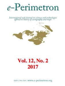
e-Perimetron

The new issue of e-Perimetron is now available at e-perimetron.org. It contains the following papers:

  • T. Čelkis, V. Karpova-Čelkienė (Vilnius) Reading signs: manuscript cartography sources of the 16th-19th century from the Vilnius University Library
  • G. Mihalakopoulos (Corfu) Alexandros Massavetas’s “Going back to Constantinople-Istanbul: A City of Absences”: mapping the past and the present through literature
  • Ch. J. J. Thiry (Golden CO) GIS-based discovery interface to paper map sets
  • K. Kozica (Warsaw) Different states of the sea chart of the Gulf of Riga by Lucas Janszoon Waghenaer (1534-1606) from his first sea atlas Spiegel der Zeevaert (1583 / 1585) in the Niewodniczański Collection Imago Poloniae at the Royal Castle in Warsaw
  • N. B. Piekielek (State College, PA) Best practices for georeferencing large scale historical fire insurance maps of the USA

 
More news can be found on the commission website.

President’s Blog: General assembly, regional conferences and scholarships

EC Meeting in Madrid, Spain

EC Meeting in Madrid, Spain

During the last Executive Committee meeting in Madrid, we have made the following decisions:

We are preparing a Call for an Extraordinary General Assembly during the ICC2017 in Washington. The purpose is to change some articles of the statues to guarantee a smoother flow of ICA activities.

Establish Regional Cartographic Conference (RCC) series in the non-ICC years. There is a clear need to have ‘local’ conferences next to our bi-annual International Cartographic Conferences, as was recently again proven by the successful EuroCarto event in Vienna. A call to organize the first RCC’s in 2018 is being prepared and will be made public by the end of 2016.

The ICA scholarship rules have been refreshed and can be found at icaci.org/scholarship. We now have scholarships available for young scientists and professionals from our member nations to participate in our ICC’s, the RCC’s and also Commission and Working Group events. There is extra funding available for cartographers and GIScientists from non-developed member states.

Menno-Jan Kraak
– President of the International Cartographic Association

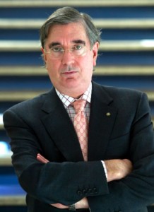
Obituary: Ramón Lorenzo Martínez

Ramón Lorenzo Martínez

Ramón Lorenzo Martínez (photo by SECFT)

It is with great sorrow that ICA received the sad news that Mr. Ramón Lorenzo Martínez passed away.

Mr. Ramón Lorenzo Martínez was a distinguished engineer and cartographer. He was the first director of the Regional Service of the National Geographical Institute in Galicia (A Coruña). He served further in the National Center for Geographic Information in Madrid, Spain and as Director of the Publication Centre of the Spanish Ministry of Public Works.

Mr. Ramón Lorenzo Martínez was highly respected in the International Cartographic Community. He was one of the faces of Spanish cartography as President of the Spanish Society of Cartography, Photogrammetry and Remote Sensing (SECFT) since 1996 and very well established within the International Cartographic Association (ICA) through his various roles in the Executive Committee (as Vice-President of the ICA from 2003 to 2007), in the conference organisation of the 22th International Cartographic Conference in La Coruna 2005, as well as most competent cartographer.

We will honour his memory.

Category: General News

President’s Blog: Education

Cartography is a domain including technology, art and science. In order to be able to fully deploy the capacity of cartography education in all these areas is key. It happens to be that respective university programmes, professional trainings, and job trainings are more and more changing their scopes and names, leaving the unique competence combination of cartographers, being able to deal with big data, modern technologies and artistic design, vacant.

It is of this reason, that programmes dealing with dedicated cartographic education are of growing importance. Let me highlight here two programmes, which ICA is taking significant note of.

  • The International Course on Management and Applied Techniques in Cartography (IC_Cartotechnology), run by the Institut Cartografic i Geològic de Catalunya, has the aim to provide a wide range of geoinformation professionals with a capacity-building instrument that covers the basis of advanced and up-to-date techniques, tools and critical thinking in cartography. It therefore integrates all the disciplines, approaches and techniques used to acquire and exploit geospatial data. Several ICA collegues have contributed to the first successful edition by giving lectures. The second edition starts in September 2014 and enrolment is still possible.
  • Three central european universities, the Technical University Munich, the Vienna University of Technology and the Technical University Dresden, are offering a joint Master Programme on Cartography. This is a 4-semester programme and it leads into a joint master degree of all three universities. Currently four intakes have been accepted and are in different stages of their studies. The programme is competitive, as only a restricted number of students can be accepted and has so far proven to be most successful in achieving the aim of educating experts with capacity in technologies, data handling and design skills.

Three older ICC proceedings digitized and available online

We are happy to announce that we digitized three older ICC proceedings and made them available on our publications page. We now have all the proceedings online since 1993. The new ones are:

We would like to thank the Swedish Cartographic Society, the Institut Cartogràfic de Catalunya and the German Society of Cartography for allowing this use and Sigita Grīnfelde for the indexing work.

We are interested to hear in the comments below if these proceedings are of any help for you.

Category: General News

Six bids for organizing the ICC2017

It’s our pleasure to announce that the ICA received six bids to host the International Cartographic Conference in 2017. Many thanks to all applicants for their willingness to host the conference. Their time and effort spent on preparing the bids is highly appreciated.

The ICA received the following bids (in alphabetical order):

The decision will be made by the executive committee in summer 2012. All details and the call for organisers can be found on the ICC2017 page.

Category: General News
rawboned-refined